How to Hike to Tolmie Peak Lookout in Mount Rainier National Park
The Tolmie Peak Lookout Trail in Mount Rainier is one of our favorite hikes in the park for its epic views over Mount Rainier and Eunice Lake. In this guide, we’ll go over everything you need to know to hike to Tolmie Peak Lookout, including how to get there, when to go, what to expect along the trail, where to stay, and more!

Are you looking for a scenic half day hike in Mount Rainier but want to avoid the crowds at the park’s more popular areas (like Paradise)?
Places like Paradise and Sunrise are popular for a reason, but we get it, sometimes you just want to head into nature without having to battle the crowds or deal with securing reservations (which are now required at these two areas in Mount Rainier!). So you’ll be happy to hear that there is so much more to Mount Rainier National Park than just Paradise and Sunrise, and there are plenty of hikes that offer similarly stunning views of the mountain as the more popular areas but without quite the same level of crowds.
If this sounds good to you, then check out the Tolmie Peak Lookout Trail. This Mount Rainier hike is a relatively easy trail that you can complete in just a few hours, but in that short amount of time, you’ll be treated to picture-perfect views over Mount Rainier, subalpine lakes, and wildflower-filled meadows from an historic fire lookout located in a lesser-visited corner of the park. No huge crowds. No reservations needed.
But before you set off on the Tolmie Peak Lookout Trail, there are some things you need to be aware of. Like how you should be prepared for an apocalyptic level of mosquitos. And how to get to this more remote section of the park. But don’t worry, that’s where we come in! In this guide, we’ll go over everything you need to know to hike the Tolmie Peak Lookout Trail in Mount Rainier National Park, from how to get there, the best time to hike, what to bring, how long it will take, and much more. Oh, and did we mention the mosquitos?
So, let’s get to it!
In this Tolmie Peak Lookout Trail guide:
The Mount Fremont Lookout Trail
The Burroughs Mountain Loop Trail
Dege Peak
The Skyline Trail
Where is Tolmie Peak Lookout?
Epic views from the Tolmie Peak Lookout Trail
Tolmie Peak Lookout is an historic fire lookout from which you can get amazing views of Mount Rainier on a clear day. The Tolmie Peak Lookout Trail is located in the Carbon River/Mowich Lake area, in the park’s Northwest corner.
The Carbon River/Mowich Lake area is quite far from the more popular areas of Paradise and Sunrise, and this remoteness means fewer crowds. We’ve often read that this area of Rainier is considered an off-the-beaten-path place to go, however we wouldn’t quite agree with that. While it does see less people, you won’t be alone, and the Tolmie Peak Lookout Trail is pretty well-trafficked, it’s just that it’s nowhere near as busy as the crowds we’ve experienced elsewhere in the park, like on the Skyline Trail in Paradise. So in that sense, I guess it does feel more off-the-beaten-path (as much as a popular and scenic place like Mount Rainier can be anyway!).
Here are some distances to the Tolmie Peak trailhead from other places in the park and in Washington:
Tolmie Peak from Paradise: 96 miles/3 hours
Tolmie Peak from Sunrise: 83 miles/ 2 hours 45 minutes
Tolmie Peak from Ashford (outside of Longmire): 72 miles/ 2 hours 15 minutes
Tolmie Peak from Ohanapecosh: 112 miles/ 3 hours 15 minutes
Tolmie Peak from Seattle: 81 miles/ 2.5 hours
Tolmie Peak from Tacoma: 48 miles/ 2 hours
Tolmie Peak from Enumclaw: 30 miles/ 1.5 hours
Basically, expect to spend about 2-3 hours driving to the Tolmie Peak trailhead from almost anywhere you’d be coming from. We’ll talk later about where you can stay to possibly cut down your drive time.
Mount Rainier National Park map
This is a map from the park brochure, where we’ve highlighted where to find the Carbon River/Mowich Lake area, and where the Tolmie Peak Lookout Trail is located.

Map of Mount Rainier National Park
Do I need reservations or a permit to hike the Tolmie Peak Lookout Trail?
While reservations for the Paradise and Sunrise areas of the park have recently been implemented, the Carbon River/Mowich Lake area of Mount Rainier remains reservation-free! So there are no reservations or permits needed for the Tolmie Peak Lookout Trail as of yet. (We’re hoping that this doesn’t make this area more crowded as a result!)
You do still need a Mount Rainier park pass to hike to Tolmie Peak Lookout, which costs $30 per vehicle and is good for 7 days in the park.
How to Get to the Tolmie Peak Lookout Trailhead
Setting your GPS for “Mowich Lake Campground” will get you to the Tolmie Peak Lookout trailhead, as this campground shares a parking lot with the trailhead.
All roads will lead you to or near the town of Buckley, where you will hop onto WA- 165, or Mowich Lake Road. Shortly after you cross the Fairfax Bridge, there will be a fork in the road. Left goes to the Carbon River area of the park, so you’ll want to keep straight to continue to Mowich Lake. Eventually, the road turns to gravel, and will remain so for about 15 miles until it ends at the Mowich Lake Campground.
These last 15 miles of Mowich Lake Road can be a bit rough. Specifically, the washboarding was pretty bad when we drove it and we got jossled around quite a bit. As the road climbs and gets closer to the trailhead, it smooths out, but it does get a little rocky in places so just drive carefully. We had a high clearance truck for the drive, but saw tons of cars parked at the end of the road. This gravel portion of the road will probably take you somewhere between 30-40 minutes to drive.

A dusty view through our windshield of Mowich Lake Road- this should give you an idea of general road conditions on the way to the Tolmie Peak trailhead
The initial part of the road is through forest, but the road climbs and eventually you come out of the treeline and are treated to great views of Mount Rainier before ducking back through the trees again just before you hit the trailhead. You’ll enter Mount Rainier National Park about ten minutes before the road ends.

Mount Rainier wasn’t out on our drive in, but it came out in full force on the way out, so I snapped this quick pic through the back window of our truck as we were driving away!

Here’s a better view of Mount Rainier after we pulled over to enjoy the view!
Mowich Lake Road ends at a parking area that services the Mowich Lake Campground and a couple of trailheads, including the one for Tolmie Peak Lookout. If you need one, there is a vault toilet restroom in the campground here. If the lot is full, cars can park along the left side of the road easily, and often, you’ll find a long line of cars parked here. This is actually more preferable anyway, given the location of the Tolmie Peak Lookout trailhead…
You can start the Tolmie Peak Lookout Trail from the parking lot, but there is another trailhead a bit further back along the road that will allow you to cut about .4 miles or so of walking around Mowich Lake.
This trailhead is found right around where the road makes its last bend before reaching the parking lot, and is marked clearly with a trail sign. Likely, the lot at the end of the road will be full and you’ll have to park along the road anyway. When we were there, we didn’t even realize the trail started back here and were unknowingly able to grab a spot just a few steps away from the trailhead.

The line of cars along Mowich Lake Road near the Tolmie Peak Lookout trailhead

Look for this trailhead marker on the left along Mowich Lake Road near the campground parking lot
How Long is the Hike to Tolmie Peak Lookout?
The Tolmie Peak Lookout Trail is a great distance for a half day hike. Here are our hiking stats for our hike to Tolmie Peak Lookout.
Distance: 5.5 miles out and back
Elevation gain: 1,600 feet
Time: Plan for about 4 hours. We spent just over 2.5 hours hiking, but spent a while up at the Lookout enjoying the views.
Trail profile:
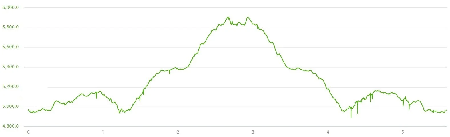
Our elevation profile from our Tolmie Peak Lookout hike
Tolmie Peak Lookout Trail Map
This map of the Tolmie Peak Lookout Trail is found in the parking area for the campground.

The trail to Tolmie Peak Lookout starts along the Wonderland Trail and then branches off on the yellow trail to the Lookout
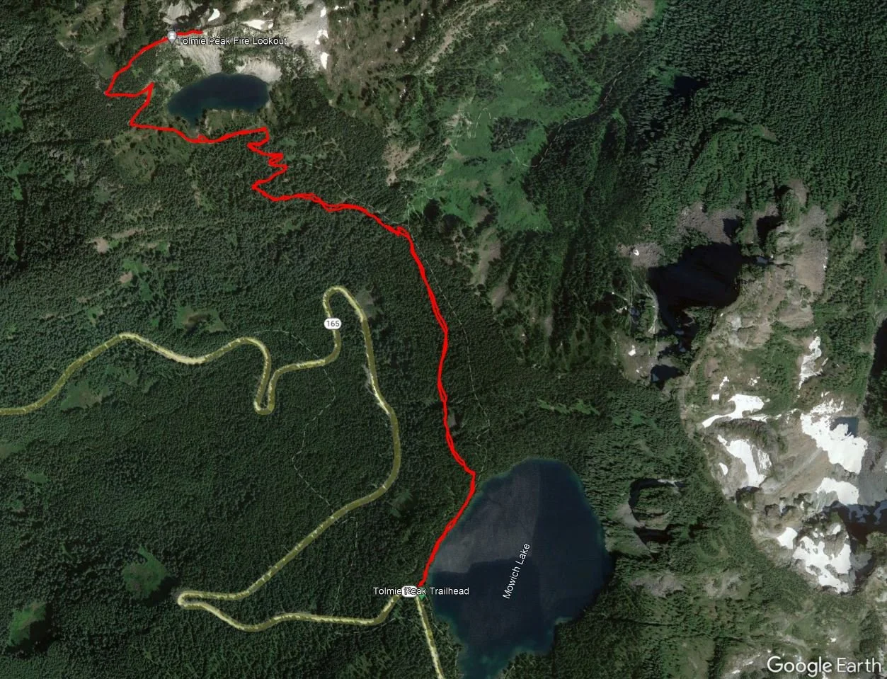
This is the satellite view of our hike to Tolmie Peak Lookout
How Hard is the Tolmie Peak Lookout Trail?
The Tolmie Peak Lookout Trail in Mount Rainier is on the easier side of moderate. There are some steady gains in elevation that get the heart pumping but other than that, the trail is pretty straightforward with nothing technical. If you want to go past the Lookout onto Tolmie Peak itself, then the trail begins to get a little sketchy with some exposure and light scrambling (you’ll see what we mean in our trail description).
Walking along the ridge trail to Tolmie Peak (past the Lookout)…this is where the trail starts getting more exposed and rugged, but it’s not necessary to get the amazing views this trail is known for…you can get those right from the Tolmie Peak Lookout itself!
The Tolmie Peak Lookout Hike: Trail Guide and Our Experience
Here’s our experience on the Tolmie Peak Lookout Trail so you know what you can expect on your hike!
As a side note, the morning of the day we hiked was cloudy and the forecast predicted clearer skies by early afternoon, which is when we decided to start our hike. However, those clear skies came much later than we were expecting. So for us, Mount Rainier was hiding in the clouds on our hike up (which is a terribly similar story to our time on the Skyline Trail in Paradise the day before!). After waiting it out for quite some time at the Tolmie Peak Lookout, the clouds did break somewhat and we were able to get glimpses of the mountain, so most of our pictures of Mount Rainier will be from our hike down. But you’ll get a good idea of the views from the Tolmie Peak Lookout hike in cloudy weather when the mountain is hiding and in semi-decent weather when it’s showing so you can see if it’s worth the hike under less-than-ideal weather conditions.
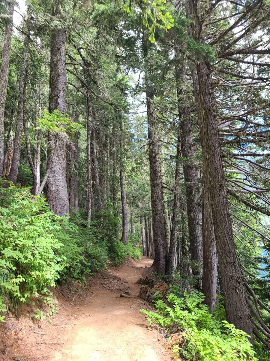
The Tolmie Peak Lookout Trail starts from the road where we described above and heads right down to the edge of Mowich Lake, where you’ll meet up with the Wonderland Trail. Head left here and follow the trail as it skirts around the shore of the lake. The trail through here is through peaceful forest, with glimpses through the trees over the lake, and if it’s a clear day, you’ll already be getting glimpses of Mount Rainier peaking out above.
The Tolmie Peak Lookout Trail as it wraps around Mowich Lake

Early views of Mount Rainier at the start of the Tolmie Peak Lookout Trail
After turning away from Mowich Lake, the trail starts a gradual climb through the forest with minimal views. Only after about 20 minutes from the start of the hike, we hit the junction with the official Tolmie Peak Trail. Here, you’ll turn left to continue up to the Lookout instead of staying on the Wonderland Trail.

The Tolmie Peak Lookout Trail climbs gently as it heads away from Mowich Lake

A peaceful walk through the forest

The trail junction for Tolmie Peak Lookout
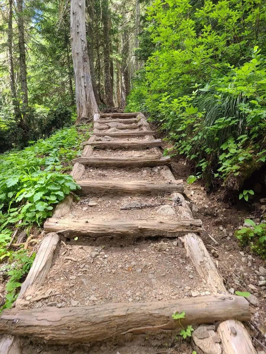
At this point, the Tolmie Peak Trail drops down a bit- about 200 feet- through a series of small switchbacks. It took us not even ten minutes to reach the bottom of the downclimb, and then the trail immediately starts regaining all the elevation you just lost.

The Tolmie Peak Lookout Trail switchbacks as it drops about 200 feet of elevation after the junction
From here, it’s a consistent climb up to Eunice Lake through the forest. It’s a steady uphill, but we wouldn’t say it’s overly steep. But the trail can get a little rugged through here with lots of rock and root obstacles along the path. There’s not much to look at here, but do keep your eyes open for deer, who are often spotted in the forest here!

The Tolmie Peak Lookout Trail starts getting a bit rugged as it climbs through the forest to Eunice Lake


Keep your eyes out for deer along the trail!
One thing that we will note here is that as we were hiking up to Tolmie Peak Lookout, lots of hikers were making their way down, and one thing that multiple actually warned us about on their way down were the bugs. We hadn’t had any trouble with them yet on the trail, and we were thinking, how bad can it really be? Well, we had no idea… but more on that in just a second.
After about 20 minutes of climbing through the forest, we emerged from the trees into an open meadow of tall brush and shrubs. The path flattens out here and a narrow dirt trail weaves its way between the vegetation.
Now, back to the bugs. As soon as we emerged from the trees, we instantly knew what everyone was warning us about. As soon as we paused at all along the trail, the mosquitos would swarm. They’re pretty bad up here. We crossed paths with people using all sorts of methods to keep them at bay…waving sticks, covering themselves in layers and hoods, using bug nets, smothering in bug spray, none of which seemed to completely work. So, be prepared for this!
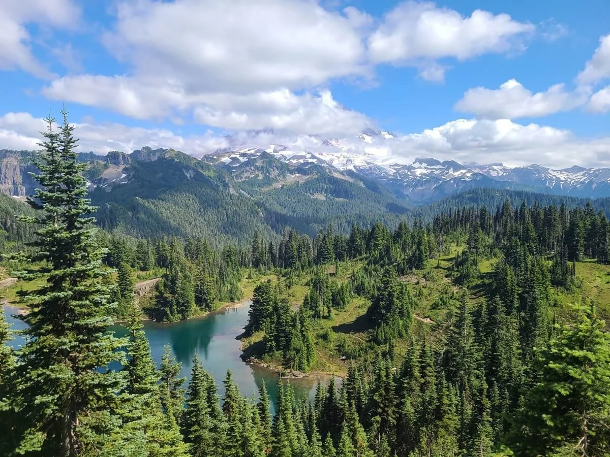
After about five minutes or so of walking above treeline, you’ll reach Eunice Lake. The main trail continues through the shrubs around the left side of the lake, but you’ll see various herd paths that will bring you to the lake shore. In the sun, the lake is a beautiful clear blue color flanked by tall rocky cliffs. On top of the cliffs, you’ll see your main destination for the day- the Tolmie Peak Lookout! To the right of it, you’ll see the ridge that stretches out from the Lookout to Tolmie Peak itself. It’s a beautiful view and one we would have loved to spend more time at, but the bugs just wouldn’t let us sit still for too long, so on we went.

Walking along Eunice Lake…can you see Tolmie Peak Lookout on the cliff ahead?

The beautiful Eunice Lake, with Tolmie Peak Lookout on the cliffs in the distance
The Tolmie Peak Lookout Trail continues around the left side of the lake through meadows filled with pretty white wildflowers, and soon begins another steady climb which will last all the way until you reach the Lookout. This final climb is about 450 feet in a little less than a mile so again, it’s not overly steep but it’s a steady push and certainly the steepest part of the entire trail we’d say. This time, however, you’ll be treated to amazing views along the climb.

The trail from Eunice Lake to Tolmie Peak Lookout
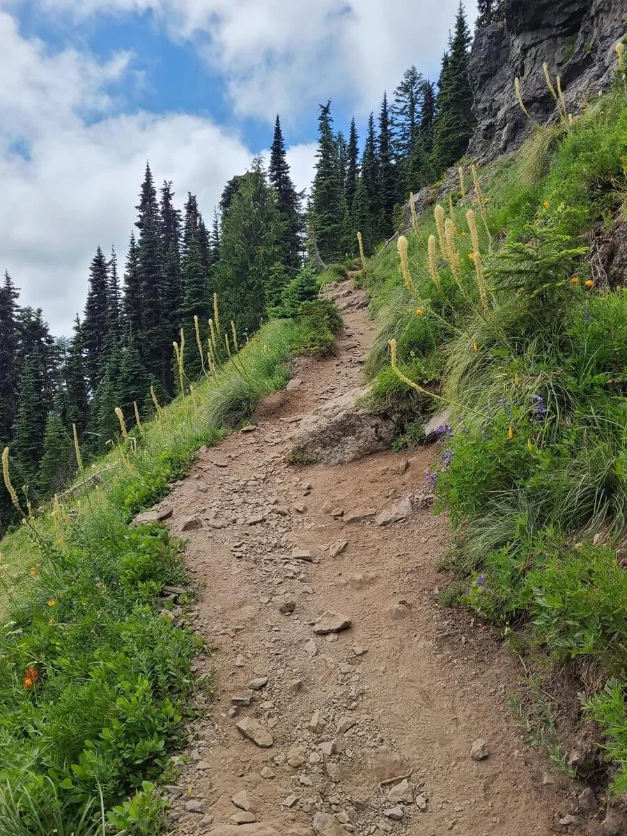
Some parts of the trail up here can get a but steep, but the views start to really open up

The view of Mount Rainier and Eunice Lake from the switchbacks up to Tolmie Peak Lookout

Getting views out to Mount Rainier through the trees
During a couple of long switchbacks up the hillside, the trees give way to picturesque views over Eunice Lake, and now Mount Rainier as well, as sort of a preview of what’s to come at the top. You’ll also eventually see views on the other side of the ridge into Carbon Valley.

A look into Carbon Valley from the Tolmie Peak Lookout Trail
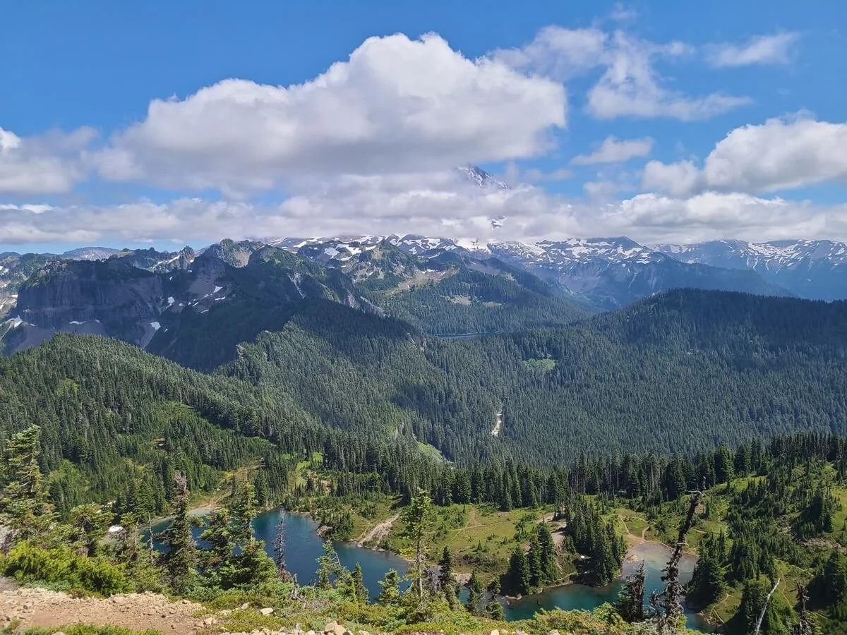
After about a half hour of steady climbing from Eunice Lake (and just under an hour and half from the trailhead), we reached Tolmie Peak Lookout! From here, you’ll get postcard-worthy views of Mount Rainier towering over Eunice Lake and the surrounding meadows. You can hang out on the deck of the old fire tower and peer inside, or just enjoy the views from the rocks below it.

Tolmie Peak Lookout
The view of Mount Rainier as it tries to peek out through the clouds!
But we have to warn you again…the bugs up here were insane. We’ve never experienced this level of mosquitos in our life! As soon as we stopped moving, they would swarm, and it was virtually impossible to sit and enjoy the view…kind of a bummer!

Trying to enjoy the views! If you zoom in on Kevin’s head, you’ll see the pile of mosquitos sitting on it!

So. Many. Mosquitos!
To add insult to injury, when we got to the Tolmie Peak Lookout, Mount Rainier was hiding in the clouds. It’s like it wasn’t even there! So we were battling bugs and had no view of the mountain (*grumbles silently*). Well, I can’t say it was all bad, because the view was still really pretty over Eunice Lake, it’s just we knew what was supposed to be there. And again, those mosquitos were next level.

This is the initial view we got from Tolmie Peak Lookout, with Mount Rainier completely hidden. It’s still a beautiful view!
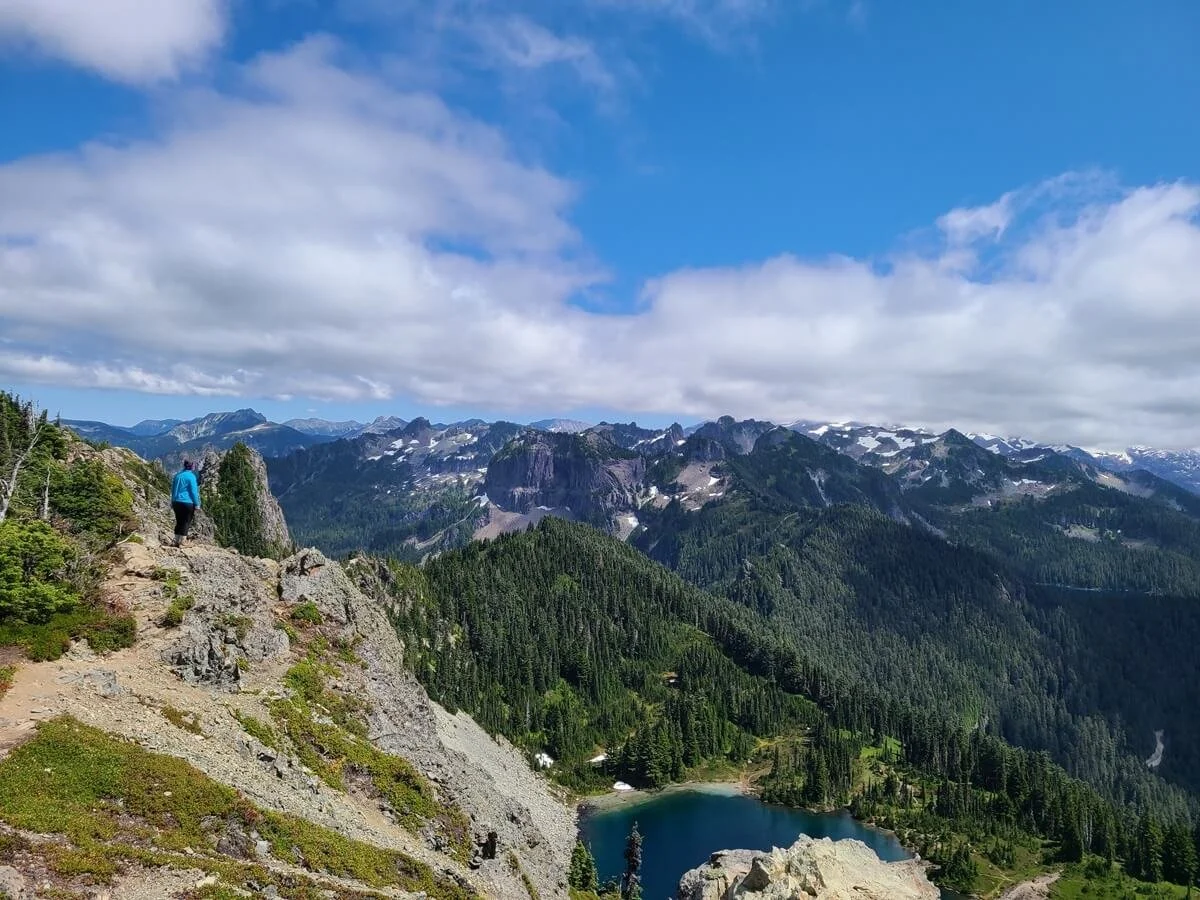
If you look beyond the Tolmie Peak Lookout, the ridge drops a bit and you’ll see a narrow trail continuing along the rocky spine ahead. This trail continues onto Tolmie Peak itself. The peak isn’t too much further or higher up, however, we will say this trail gets kind of sketchy the further you go. Some parts are okay, but other parts require you to navigate rocks, roots and brush along a narrow trail that sometimes gets pretty close to the edge of a big drop-off. A few parts are even short scrambles. We went down this trail a little bit but ultimately decided it wasn’t worth continuing on.

A view of the Tolmie Peak Trail as it continues along the narrow ridge to the Tolmie Peak summit in the distance

The rugged path along the ridge to Tolmie Peak beyond the Lookout

This trail gets steep, narrow, and rocky

A look up the narrow ridge trail to Tolmie Peak

Steep drop-offs on the ridge to Tolmie Peak

Here’s an idea of what the exposure is like along the ridge to Tolmie Peak!
We would, however, recommend going even just a tad bit along the ridge before it gets too sketchy, for a few reasons. For one, it’s an easy way to remove yourself from the “crowds” at the Lookout. We say “crowds” because there really weren’t that many people there, but we always like to find our own little quiet spots when we can. Secondly, the ridge had more of a breeze crossing over it that seemed to be the magic solution for keeping the mosquitos away, which was amazing. And finally, the views weren’t any different over here than from the Lookout, and in fact, we would almost say they were better. From the Lookout and the area below it, part of Eunice Lake gets obscured from the shrubs running down the slopes in front of the Lookout. When you’re on the ridge, because it’s a steep drop off without much vegetation on the slopes, it’s a clear shot over the lake. Both perspectives are great, though.

Beautiful views from Tolmie Peak Lookout

Loving these views from the Tolmie Peak Lookout Trail!

Mount Rainier and Mowich Lake beneath it
We decided to hangout at the top for a bit to see if the clouds would clear. They did start to thin out to a point where eventually parts of Rainier were peering through, but they were stubborn. They kept changing by the minute…revealing the mountain one minute and covering it the next, and just when we thought the mountain would finally come out completely, the clouds would form again. After waiting for about an hour and a half at the top, we decided the view of the mountain was about as good as it was going to get, but we were happy with it, and we had a long drive back to camp, so we started the hike back down, happy to leave the tortuous mosquitos behind.
The hike down from Tolmie Peak Lookout was easy to go fast on. The only annoying point was that 200 foot climb back to the junction with the Wonderland Trail but it’s over with pretty fast. We were able to get back to Mowich Lake in about an hour and 15 minutes.

The hike out from Tolmie Peak Lookout is fast and easy

The annoying 200 foot climb back to the Wonderland Trail junction!
Best Time to Hike the Tolmie Peak Lookout Trail
The best time to hike to the Tolmie Peak Lookout is around mid-July to October. This is most likely when you’ll have a snow-free trail and when Mowich Lake Road is most likely to be open. We hiked to Tolmie Peak Lookout towards the end of July and while we still encountered snow on trails in Sunrise and Paradise, this trail was completely snow-free. Still, be sure to check trail conditions and road status before heading out.
In terms of the best time of day to hike to Tolmie Peak Lookout, I’d say it doesn’t matter too much. There seems to be a steady flow of people along the trail all day. Some people like to get to the Lookout for sunrise or sunset, while many people go midday. We decided to start our Tolmie Peak hike midday, around 12:30 pm, because we were trying to wait out the clouds, and because we were staying a couple of hours from the trailhead. And actually, I think we somehow timed it right on the trail, because as we were heading up, there were lots of people hiking down from the morning and there was really only a handful of people at the top coming and going.
If you really want to keep the crowds down on this trail, it’s probably best to avoid weekends (or get there early). We hiked the Tolmie Peak Trail on a Thursday, which also might explain why we didn’t encounter too many people at the Lookout.
We will warn you that when you get to the end of Mowich Lake Road, you might be surprised by the number of cars lining the road before the lot. We sure were. They probably spanned over a half a mile or so from the lot. But many people might just be here for the campground, the Spray Park Trail, the Wonderland Trail, or are just visiting the lake, and we didn’t feel that the number of cars here were at all representative of the number of people on the Tolmie Peak Trail. But it’s another reason why it’s good to time your visit when there won’t be peak crowds (like on weekends), because we were told the line of cars can run for miles and unless you get lucky and can snag an open spot closer to the trailhead, this will add quite a bit of distance to your overall hike.
What to Bring on the Tolmie Peak Lookout Hike
Aside from the usual day hiking essentials, here are some things we would recommend specifically for the Tolmie Peak Lookout Trail.
Bug spray/bug net- This is our number one recommendation! (Seriously, did we mention the mosquitoes enough times?!). We found that the mosquitos were so feisty that bug spray only kept them at bay for ten or fifteen minutes, but at least it was something. A bug net would be super helpful to keep them away from your face at the very least.
Bear spray- Mount Rainier is home to black bears and we wouldn’t recommend hiking without bear spray in case of an emergency, and being bear aware on the trails.
Sun protection- You’ll probably want to hang out at the Lookout for a while and it’s completely exposed to the sun.
Hiking shoes- The trail can get a little rugged, and especially if you want to hike out to Tolmie Peak beyond the Lookout, hiking shoes are a must.
Food/water- Pack a lunch and bring plenty of water. There are no amenities in this park of Mount Rainier!
Where to Stay near the Tolmie Peak Lookout Trail in Mount Rainier
If you want to stay pretty much at the trailhead for the Tolmie Peak Lookout Trail, then you can camp at Mowich Lake Campground. This is a pretty primitive walk-in site only that has 13 tent pads, vault toilets, and no potable water (so bring plenty of your own!). The campground is generally open from early July to early October and while free, it does require a Wilderness Permit. There are three ways to get a Wilderness Permit, including an early access lottery, an advanced reservation period, and as a first-come first-served permit, and these processes start as early as February each year so be sure to check the link to read more about this process if you want to camp here.

The entrance into Mowich Lake Campground near the Tolmie Peak trailhead

Walk-in sites at Mowich Lake Campground
Other than staying at the Mowich Lake Campground, you’ll likely have to drive 2-3 hours depending on where you’re staying (likely places include Seattle, and other regions of Mount Rainier including Sunrise or nearby, Paradise, Longmire, Ohanapecosh, or Ashford). There are limited lodging options and RV parks available in the Buckley and Enumclaw area about an hour away from the trailhead.
Can I stay overnight at Tolmie Peak Lookout?
Unfortunately, there is no backcountry camping along the Tolmie Peak Lookout Trail or at the Lookout itself. If you want to spend the night in the backcountry nearby, Ipsut Creek and South Mowich River Campgrounds are found along the Wonderland Trail in the general area but will still be a significant distance off the Tolmie Peak Lookout Trail itself. You could always try to get a permit for the Mowich Lake Campground. Though not completely backcountry, it is pretty primitive and will allow you to get on the trail quickly.
Tips for Hiking to Tolmie Peak Lookout in Mount Rainier
Fees for visiting Mount Rainier
Though there is no official entrance gate for the Mowich Lake area, you are still required to have a Mount Rainier park pass, which costs $30 per vehicle and is good for 7 days. Be sure to buy it online in advance and print it out to leave on your dashboard, or buy it at one of the park’s entrances near Sunrise or Paradise. If you’re looking to visit more Washington National Parks and federal recreation areas, check out the America the Beautiful Pass, which is an annual pass that gets you into all National Parks for an entire year! It’s totally worth it if you plan to visit other nearby parks like Olympic National Park, Mount Baker, or the Enchantments.
Check Tolmie Peak Trail conditions
Especially if trying to hike to the Tolmie Peak Lookout earlier or later in the hiking season, be sure to check the status of Mowich Lake Road, and recent trail conditions and reviews from other hikers.
Be prepared to not see Mount Rainier
While most people hike the Tolmie Peak Lookout Trail for the amazing views of the mountain over Eunice Lake, just be sure to set your expectations. Absolutely check the weather ahead of time and try your best to time your hike with clear skies (which can be few and far between around Mount Rainier!). Even if a clear day is forecasted, Mount Rainier might still decide to hide behind a veil of clouds. If that’s the case, be patient! It might eventually show itself. This strategy didn’t work for us on the Skyline Trail, but it did pay off for us here on the Tolmie Peak Trail, and we eventually were able to see most of the mountain peeking through the clouds. Of course, it wasn’t until we back in our car driving out that the mountain decided to come completely out, but that’s mountain weather for you.
Can I bring my dog on the Tolmie Peak Lookout Trail?
Unfortunately, dogs aren’t allowed on trails in Mount Rainier National Park.
Fill up your tank
If you’re driving to the Tolmie Peak trailhead from the east side of Mount Rainier (such as from Sunrise and Ohanapecosh), gas stations are few and far between, and the ones that do exist (like in Packwood and Greenwater) are quite expensive! We noticed Greenwater was almost an entire dollar per gallon more expensive than Packwood.
Download any important information before heading out
Download Google Maps and any trail information/maps you need before heading out, as service is limited in this part of the park.
More Mount Rainier Hiking Guides
While the hike to Tolmie Peak Lookout is great, Mount Rainier is full of amazing trails. Learn more about some of the best hikes in Mount Rainier National Park, and check out our trail guides to some of our favorites, including:
The Burroughs Mountain Loop- an epic hiking loop in Sunrise that takes you to up-close views of Mount Rainier
The Mount Fremont Lookout Trail- another hike to a fire tower with amazing views of Mount Rainier from the Sunrise area
Dege Peak Trail- a lesser-traveled trail in Sunrise with great views of the mountain
Skyline Loop Trail- one of the most popular trails in Mount Rainier in the Paradise area, and for good reason!
More Washington Travel Guides
Heading on a Washington road trip and visiting other parks besides Mount Rainier? Let us help you plan your trip!
MOUNT RAINIER NATIONAL PARK ITINERARIES: Learn how to plan your time in the park with our 3-4 day Mount Rainier itinerary. If you only have one day in the park, be sure to check out our One Day in Mount Rainier Itinerary where you’ll hit both Sunrise and Paradise in just a day!
NORTH CASCADES NATIONAL PARK: Hidden Lake Lookout Trail guide
MOUNT BAKER: Check out our favorite hikes around Mount Baker, plus learn more in our trail guides for the Chain Lakes Loop, the Ptarmigan Ridge Trail, the Skyline Divide Trail, and the Park Butte Lookout Trail!
Are you looking to hike the Tolmie Peak Lookout Trail in Mount Rainier? Let us know how it goes, and if you have any questions, we love to help!