32 Must-See Places Along Iceland's Ring Road (and suggested itineraries!)

Iceland has it all…volcanoes and mossy lava fields, glaciers and snow-capped peaks, hot springs and geothermal hot spots, waterfalls and… more waterfalls. What if I told you there is a way you can experience all of this and more by doing just one thing during your trip to Iceland? Sign me up, right?!
The answer? A road trip down Iceland’s ring road! You can experience all the beauty that Iceland has to offer while driving around this 828-mile stretch of road that encircles the entire country. You’ll drive through the southern coast full of famous waterfalls, epic glaciers, and iconic black sand beaches, head through the eastern fjords with cute coastal towns and plunging seaside cliffs, and traverse the north coast where you can visit geothermal hot spots and powerful waterfalls. There’s a reason why this is one of the most popular things to do in Iceland!
We know that planning a trip around the ring road can seem intimidating…there’s so much to see, where do you even start?
Well, you’ve come to the right place! We spent two weeks in Iceland traversing around the ring road (plus a ton more!) and we would love to help you out! So, we’re here to share with you some of the best places along Iceland’s ring road to give you a jump start on planning your perfect Iceland ring road itinerary.
We’ll answer all your burning questions about driving the ring road (or we’ll try to anyway, we’re not total mind readers!), like, when should I drive the ring road, or, which way should I go, or, where should I go, or, how much time do I need to drive the ring road?
If you’re looking for advice on any of those questions, stick around, because we’ll cover it all. So, let’s get right to it!
Article Contents
Tips for Driving Iceland's Ring Road
Before we get into the good stuff about all the awesome places to see along the ring road, you might be wondering about the logistics of planning a road trip through Iceland.
How do I rent a car? Is it easy to get around? What kind of insurance should I get? What else do I need to know that I’m not even thinking of?!
Driving in Iceland can be a stressful and daunting experience, so if you’re planning on a road trip, it’s good to come prepared and knowing what to expect.
But while we’re talking about it now, here are two quick tips that will help you start planning your ring road trip…
The best time to drive Iceland’s ring road
The ring road can be driven any time of year, actually, but late spring, summer, and early fall are the best times to drive in Iceland. During this time, the roads are clear of snow which makes driving conditions much safer and easier.
In the winter months, starting as early as October in Iceland, conditions can become hazardous, as the roads can become covered in snow and ice. The ring road usually remains open but a 4 wheel drive vehicle is needed, as well as a confident driver used to driving in winter conditions.
A note a bout Iceland’s F-roads: If you are planning to detour off the ring road at any point in time and venture off into the Icelandic highlands, you’ll absolutely need a 4x4 vehicle. Getting to the highlands requires driving along rough F roads… these roads are long, bumpy, eroded dirt and gravel roads that lead to some of Iceland’s most spectacular scenery. But, they’re only open sometime around mid-June to mid-September when they are clear of snow and ice, so if planning on making a trip here, be sure to time your ring road itinerary accordingly!
Which way should you travel around the ring road?
From Reykjavik, you can choose to start off clockwise or counter clockwise to drive around the ring road. Which is best?
Neither! It really doesn’t matter which way you go… you’ll see the same awesome scenery no matter which direction you are driving.
That said, the only thing that would really matter when choosing your direction is the weather situation. You’ll want to get as clear weather as possible when driving Iceland’s southern coast so that you have the best chance of seeing those epic glacier views Iceland is so famous for!
Our first week in Iceland was spent along the southern coast, and despite traversing the same stretch of road day after day, we had absolutely no clue there were giant glaciers looming over us all along the ring road! The weather was rainy and overcast, and the clouds were so low that they were covering the tops of all the mountains and cliffs that lined the road.
Then, the first sunny day we had, we were in shock! We couldn’t believe all this beauty was right in front of us the whole time and we were totally oblivious. It’s stuff you want to try not to miss. We were even talking to another group later on in our trip who said that when they visited the famous glacial lagoons, they couldn’t even see across the lagoons to the actual glaciers because of the gloomy weather they had.
So, our advice? Play it by ear. This requires flexibility and spontaneity for sure, but Iceland’s weather is pretty unpredictable, so you can’t really plan in advance, unfortunately…
When you arrive is Iceland, check the weather. It’s said to be pretty accurate for up to 48 hours in advance. If sunny days are ahead, take advantage of this and go along the southern coast. If not, and rainy days are in the forecast, you might want to start off by going counter clockwise and heading up the western side of the country. While still beautiful, it’s a little less epic (although let’s be real, all of Iceland is pretty epic) and there aren’t as many stops to make along the actual ring road as you head towards the northern coast.
The Best Places Along Iceland’s Ring Road
Ok, with the logistics out of the way, now it’s time for the fun stuff! Where should you go on your grand ring road adventure?!
Iceland has an endless list of out- of- this- world, epic, beautifully mind-boggling places to see! And luckily, many are situated right along or near the ring road!
But how do you choose? Chances are you don’t have months to dedicate to travelling around this beautiful country (but one can dream, right?).
We’ll share with you here some of the best places that you can get to along Iceland’s ring road with just one to two weeks on hand (we’ll give some ring road itinerary suggestions below based on if you have more or less time in Iceland!).
All of the places we list here are accessible with a 2-wheel drive vehicle and most are right off or pretty near the ring road. The ring road is pretty much paved and smooth the entire way, and a 2WD vehicle is sufficient.
Keep in mind, though, that some places require a slight diversion off the ring road down short gravel or dirt roads. These roads aren’t F roads, so they don’t require a 4x4, and your 2WD vehicle should be just fine, but just keep in mind, these roads can get rough and a bit bumpy. Take it slow and be vigilant about traversing potholes and rocks and you should be good! We’ll note where you’ll find these throughout this itinerary.
Best places along the south coast ring road in Iceland
Iceland’s south coast is the most visited section of Iceland’s ring road, and it’s no surprise!
It’s filled with hundreds of waterfalls, epic ice caps and glaciers, the famous black sand beaches, and provides the gateway into the famous highlands of Landmannalauger and Thorsmork.
A lot of people recommend the Golden Circle as the first option for people who only have 2 or 3 days in Iceland, but I’d say touring the southern coast is the far better way to go! It jam packs into a short stretch of road so much of what makes Iceland unique and absolutely breathtaking.
Here are some of what we would consider the best places on the ring road along Iceland’s famous south coast!
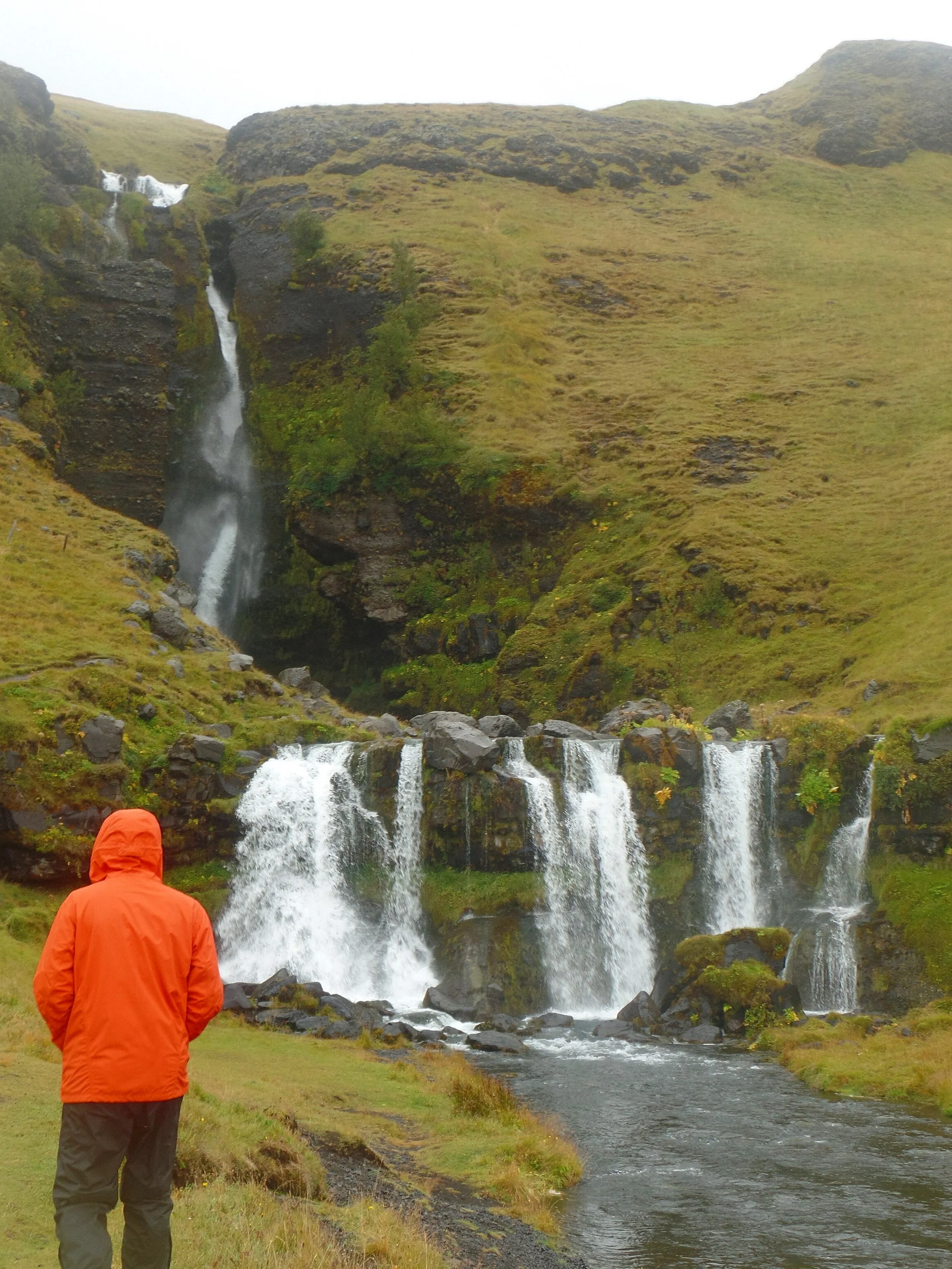
1. Gluggafoss

Gluggafoss is the first stop on the list, and the first of many, many, many waterfalls (yea, Iceland has a lot of waterfalls in case you didn’t know!) you’ll see along the ring road in Iceland. But this is a good one to start off with!
Why? This waterfall is much less visited than the more popular places even though it’s only a light drive off the ring road. In fact, we had the falls all to ourselves for a good 15 minutes and there were never any more than 3 cars in the parking lot.
And although it’s less popular, it still has a true Icelandic feel, as it’s set back into the cliff side and surrounded by green mossy canyon walls. An added bonus is that you can get pretty close to it and walk between it’s two tiers.
Getting here: To get here, you’ll drive down the ring road from Reykjavik until you get to the town of Hvolsvollur. Make a left onto route 261 and drive down this paved road for about 15 minutes. You’ll actually pass by several waterfalls cascading down the roadside cliff, but you’ll know when you reach Gluggafoss when you see the parking lot to your left.
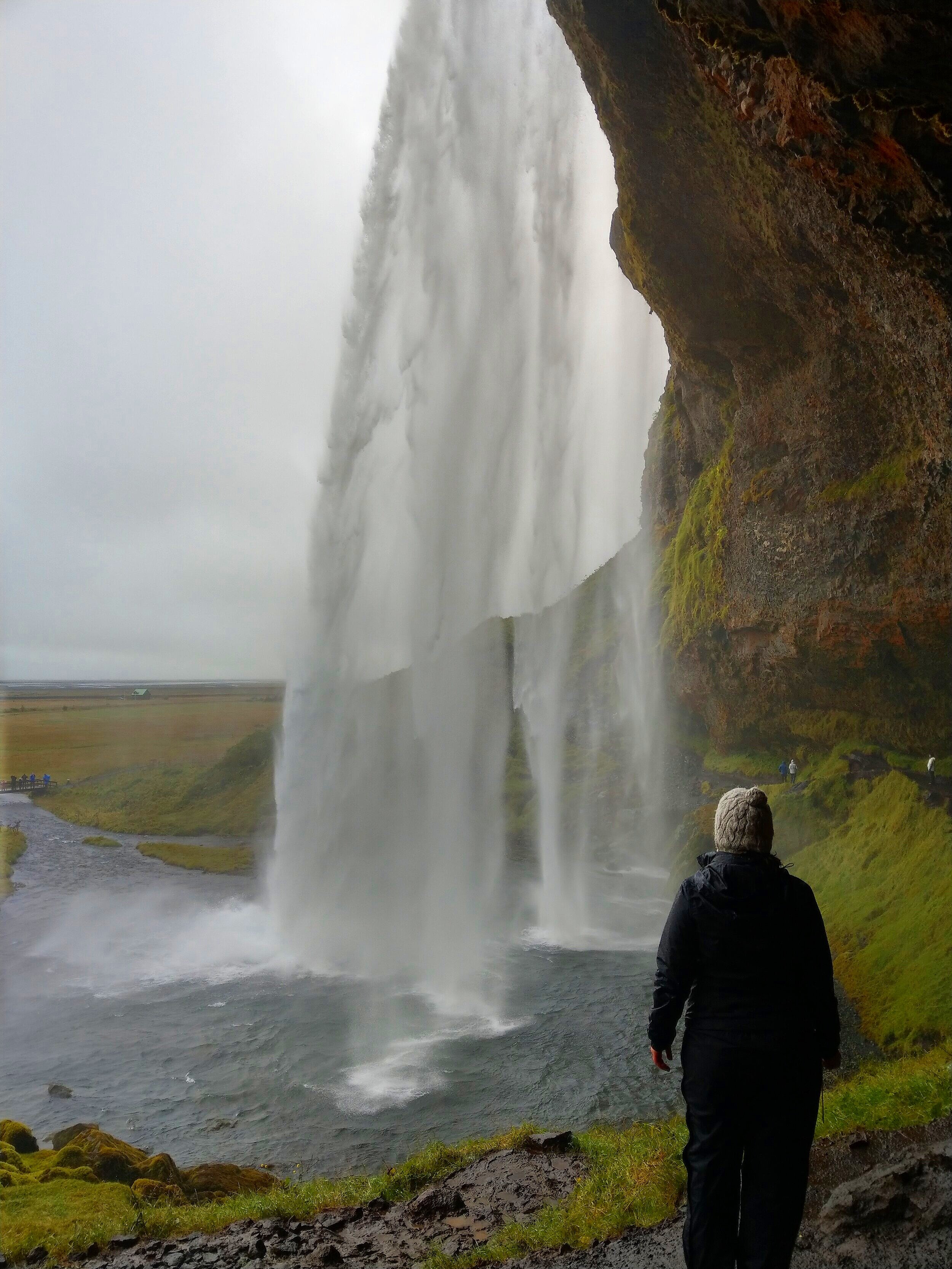
2. Seljalandsfoss
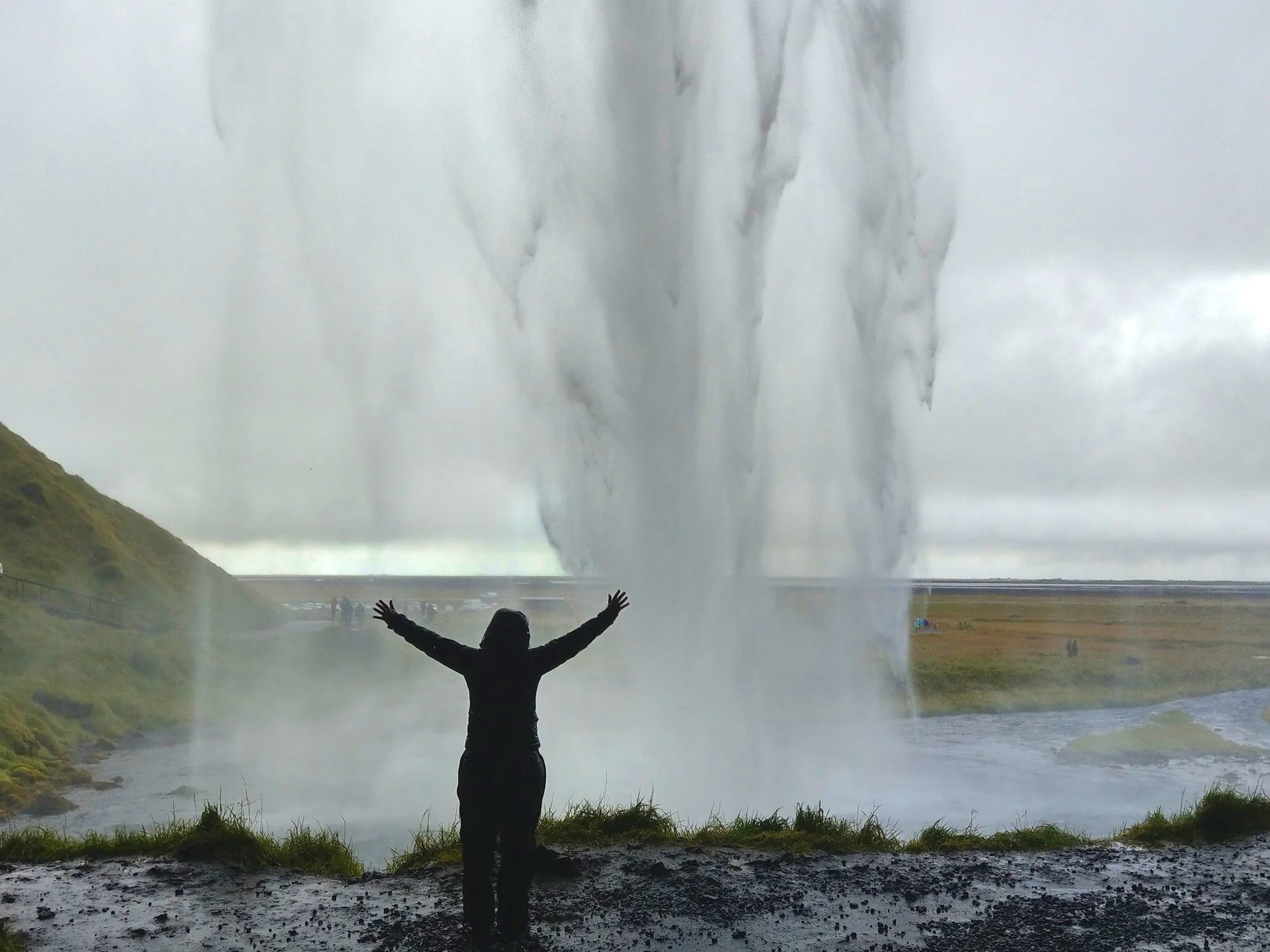
Your next stop on Iceland’s ring road is another waterfall, but this one is just a tad more popular. And by a tad, we mean a ton.
It’s actually one of the most iconic falls of Iceland, popular because of the opportunity to walk behind the powerful falls and snag some really cool pictures. So, don’t expect to have this one to yourself! It’s busy around the clock here, with tour buses unloading the masses on the regular.
Despite the crowds, we think it’s still well worth a quick stop if you’re driving the ring road just to experience the power and beauty of the falls. To try and avoid the crowds, come early in the morning or later in the evening when tours have stopped…it should be a much quieter (though we’re still not talking having it to yourself) than midday.
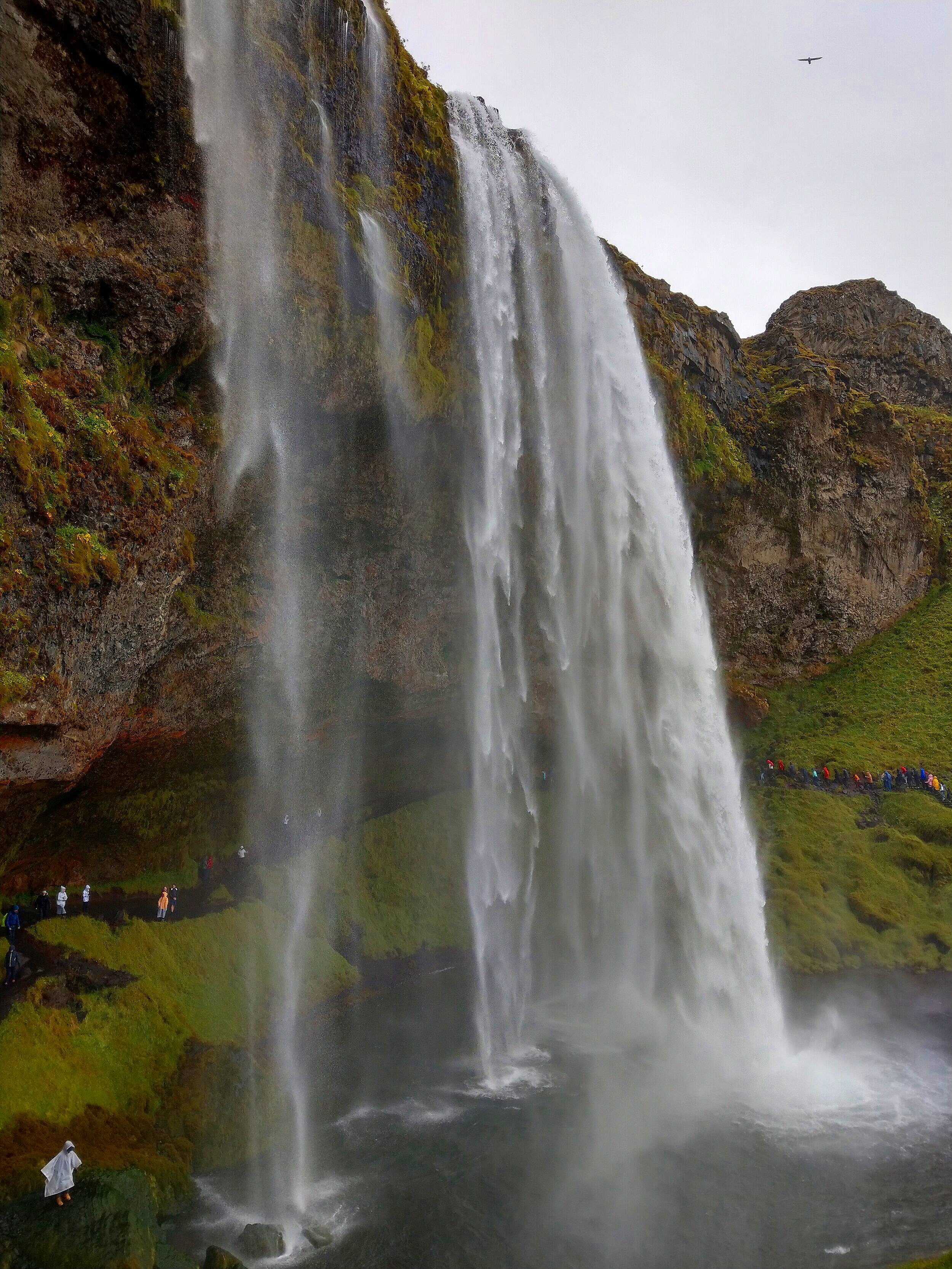
Getting here: Seljalandsfoss is clearly visible from the ring road as you approach from the west. Take a left onto route 249 and the parking lot will be almost immediately on the right. The handfuls of tourist buses should give it away. There is a parking fee of 700 ISK to park in this lot, which you can pay at an on-site kiosk with a card.
This stop doesn’t just have Seljalandsfoss, though. There’s actually a short, paved, flat walking path that will take you past a few more smaller waterfalls cascading down the cliff side. And after a 10 minute stroll, you’ll eventually reach the next destination on our list…
3. Gljufrabuifoss

We noticed a pattern while touring Iceland’s ring road…the more unpronounceable the name, the cooler it is! This waterfall is no exception to that rule.
Some people say Gljufrabuifoss is a hidden gem. We say it’s not. This waterfall is clearly visible from the road and has its own parking lot with a tourist attraction sign. Plus, the walking path from Seljalandsfoss leads right to here in 10 minutes or less.
With that said, you will find less people here than at Seljalandsfoss, primarily because tour buses don’t stop here and the bus only stays at Seljalandsfoss for a short time, and that doesn’t allow for a lot of people to make the walk over before the bus leaves. But, certainly don’t expect to be alone.
In our opinion, Gljufrabuifoss is way better than Seljalandsfoss. In fact, this was one of my favorite stops along the ring road, and quite possibly my favorite waterfall in Iceland (though there are one or two other contenders…I mean, it’s Iceland, there’s lots of them!).
From the road and walking path, you can only see the top of Gljufrabuifoss cascading over the top of the cliffside above you, but not the bottom. A short narrow rock tunnel leads the way to the base of the falls. You’ll have to rock hop your way down the small stream that flows out of this rock tunnel, which then opens up to a scene that makes you feel like you’re in a fairy tale.
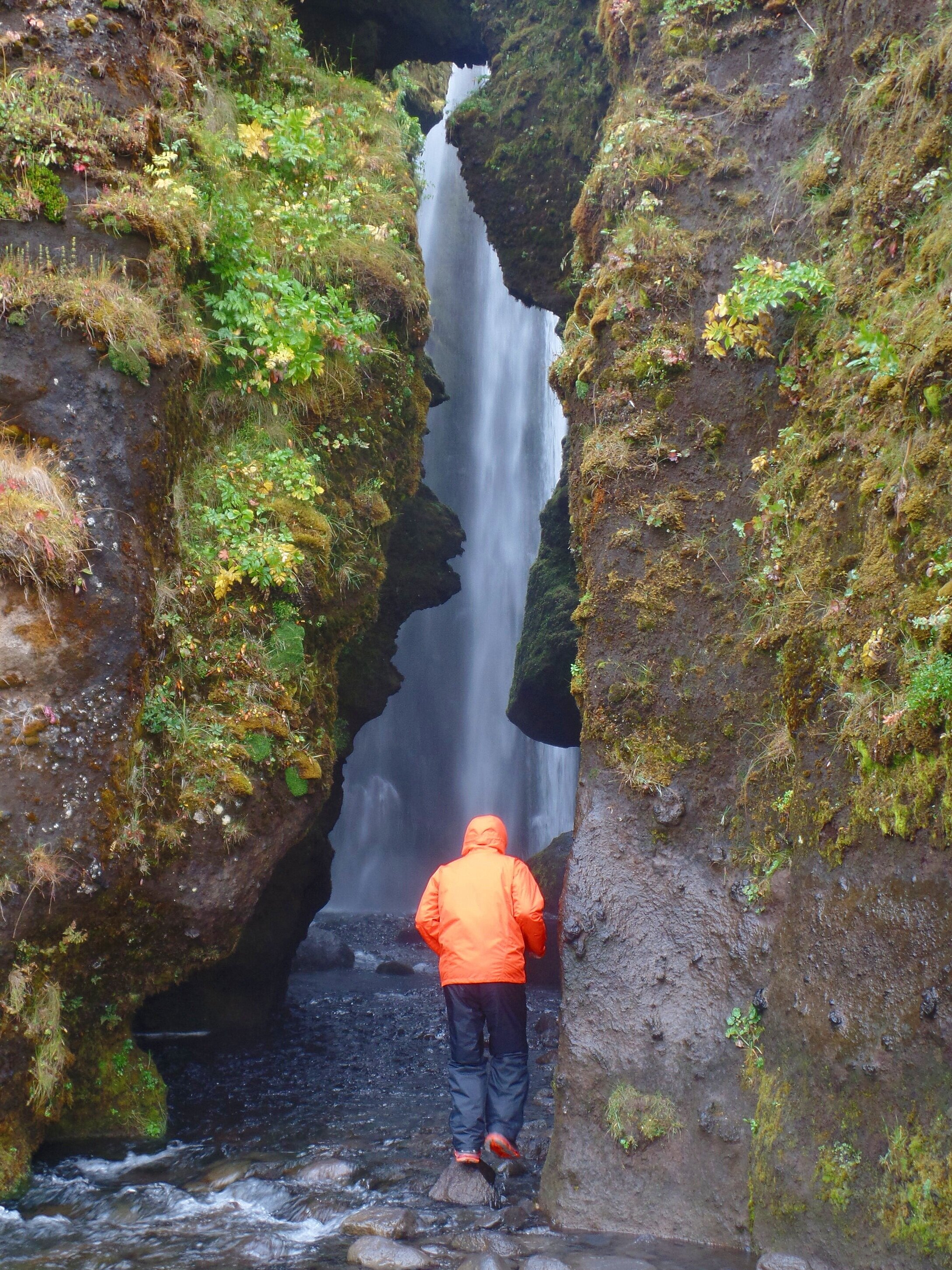
You’ll find yourself in a small mossy space with the powerful Gljufrabuifoss pounding down right in front of you. Expect to get very wet here, so again, make sure you wear the right waterproof gear and shoes!
Getting here: Gljufrabuifoss is a 60 second drive past Seljalandsfoss up route 249. You’ll see a long narrow parking lot on the right side of the road that’s right outside of a campground. At the end of this parking lot, there’s a short path that leads you right to the falls. Or, walk here from Seljalandsfoss!
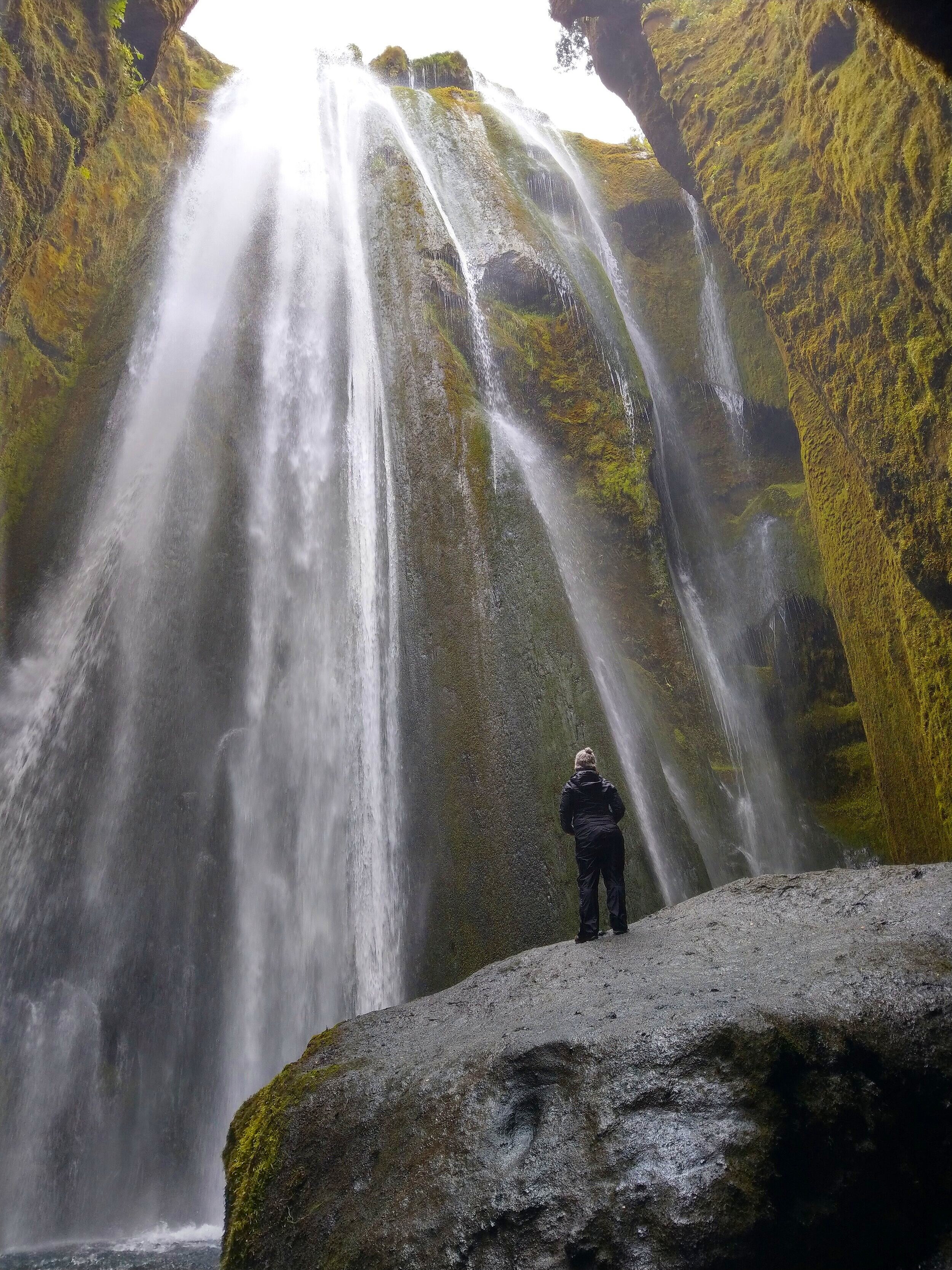
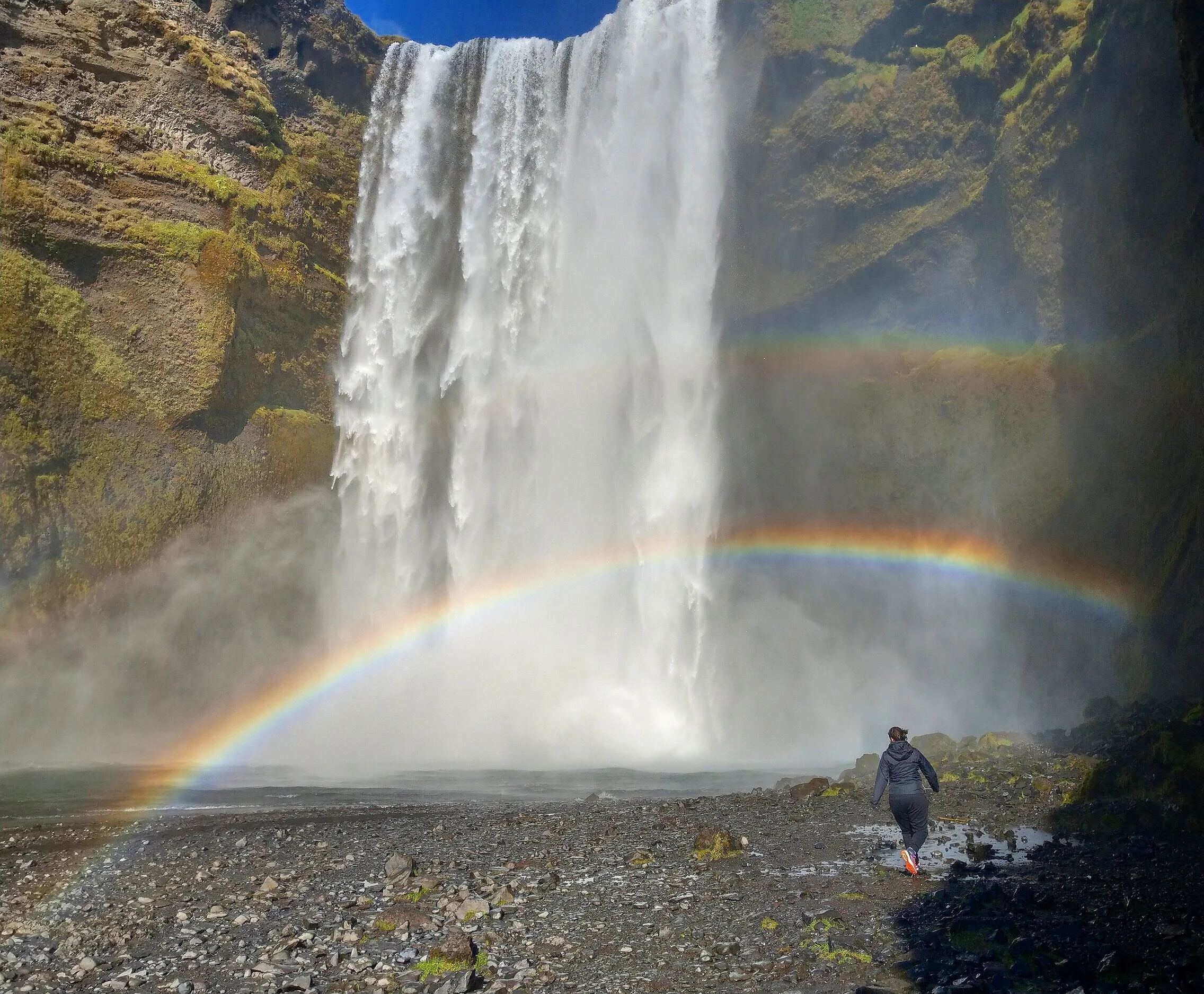
4. Skogafoss
Surprise, surprise…guess what’s next on our list. Another waterfall!
Skogafoss is another staple of any Iceland ring road itinerary, and probably the most famous waterfall in the entire country.
I thought the crowds might take away from the experience, but it didn’t at all. This one is worth a visit! We loved it so much that we ended up visiting Skogafoss three times during our ring road trip! There’s just something about getting up close and feeling the power of the falls crashing down…I never felt anything quite like it!
When visiting Skogafoss, you can simply admire the falls from a distance, or you can get a little bit more up close and personal. If you want to get up close, you’ll get absolutely soaked, so bring along rain gear and shoes.
There’s also a set of stairs that climbs the side of the falls (somewhere around 400! I lost count somewhere in the 200s…). From the top, you get a good vantage point looking down to side of the falls, and in the distance, you can see the ocean.
From this point at the top of the falls, a trail weaves it’s way further inland along the river.
This is actually the start of the famous Fimmvorduhals trek through the Icelandic highlands to Thorsmork, so you’ll see a lot of backpackers and day hikers coming and going.
Even if not hiking the full Fimmvorduhals trail, you can still continue down this trail past the top of Skogafoss for a nice half day hike. You’ll follow the Skogar river as it flows from the Myrdalsjokull and Eyjafjallajokull (that’s a mouthful, huh?) glaciers, before plummeting over the Skogafoss falls and out to the Northern Atlantic. On your way, you’ll be treated to some epic Icelandic views and even more beautiful waterfalls (supposedly there’s 26 altogether!)
To follow the river long enough to see all the falls, it will be about a 10 mile round trip that is gradually uphill out and downhill back. Of course, you can turn around whenever you’d like, but the further you get, the more you escape the crowds and the more of Iceland’s beauty you see.


Getting here: Skogar is located about 30 minutes past Seljalandsfoss. You’ll see Skogar from the ring road on your left, with the mighty falls setting an epic backdrop. Drive through town and follow signs leading to the waterfall parking lot. It’s free to park but you’ll have to pay to use the bathrooms here, so make sure to carry some small cash with you. There’s also an information center here that will inform you of conditions along the trail above the falls.
5. Kvernufoss
Ok, the southern coast is filled with epic waterfalls, but we swear, this is the last waterfall on our list… for at least a little while anyway!
Kvernufoss was on our to-do list in Iceland, but we sadly never made it, although we did try. A for effort, right? Even though we didn’t get there, we still wanted to put this one on the list, since it seems like such a special place.
Kvernufoss is much less-visited waterfall that neighbors the oh-so popular Skogafoss. This truly is a hidden gem, and you might actually have it all to yourself! Another draw to this one is that, like the more popular Seljalandsfoss, you can walk behind this falls for a unique perspective.
Getting here: Drive into the town of Skogar and instead of heading to the Skogafoss parking lot, head towards the museum. Past the museum, you’ll see two large white buildings. We pulled our car in between these and saw a gate at the edge of the grass leading to a trail. However, a sign on the gate said that museum entrance was required to enter. We also didn’t see any other cars parked here, so we were a little nervous. We were just too skeptical about Icelandic parking laws and it kind of felt like we would be parking on private property where we didn’t belong. Being content with all the other waterfalls we had seen that day, we were ready to just call it a night.
Apparently, it’s okay to park your car there, and the short trail to Kvernufoss begins behind the last building on the road. Check out here and here to learn how to avoid our mistakes and actually be able to see this waterfall! It looks pretty epic and isolated and this one remains on our list for next time! (And yes, there will be a next time…Iceland is just too good of a place to only visit once!)
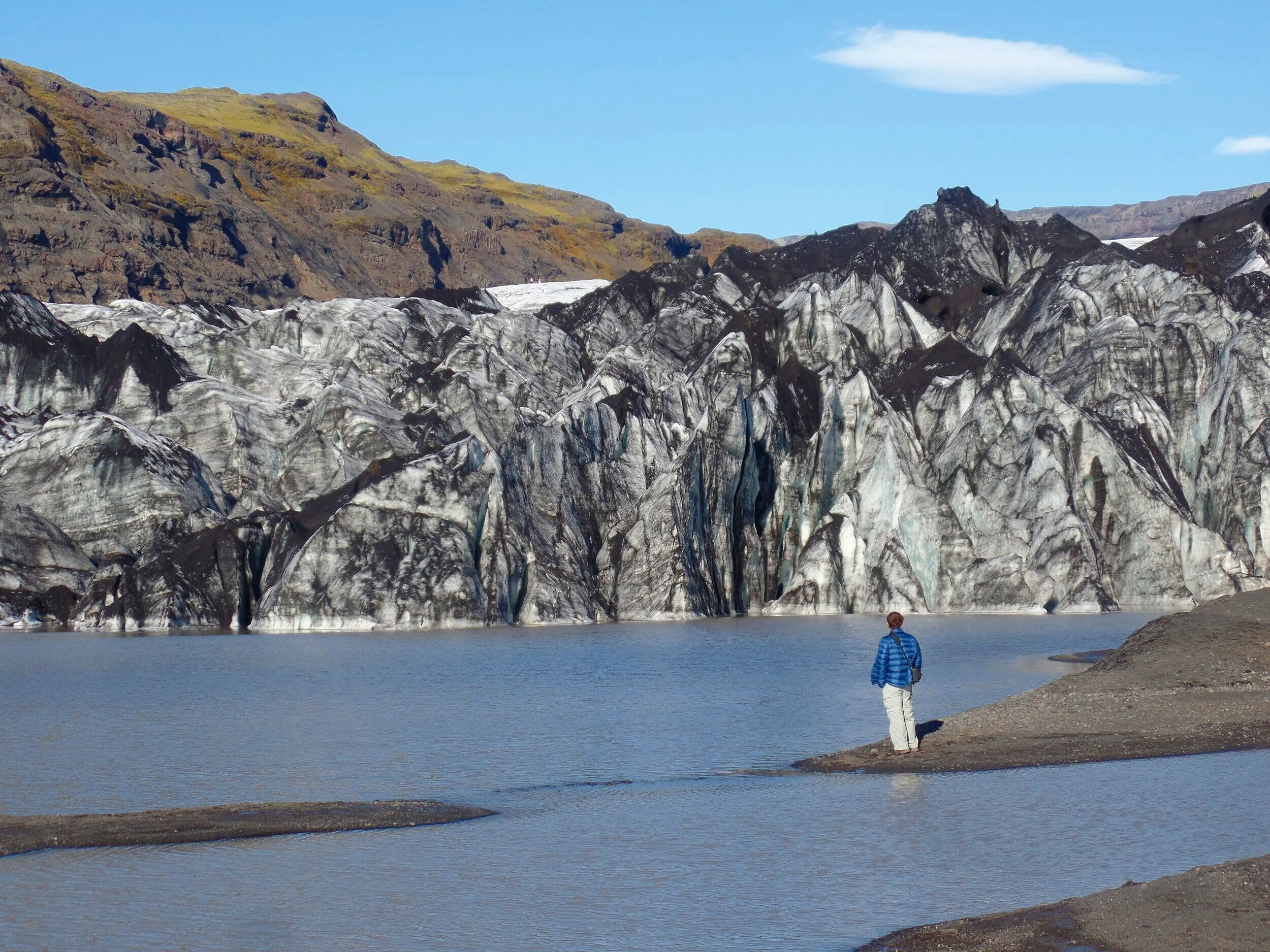
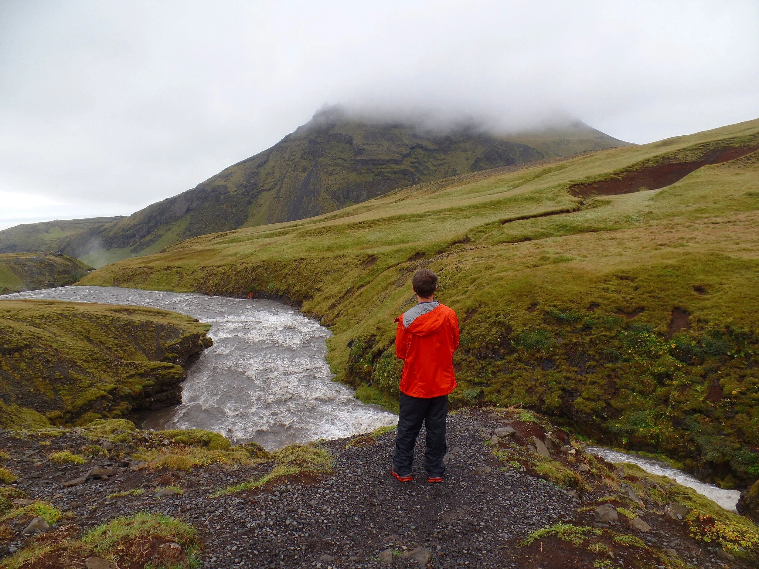
6. Solheimajokull Glacier
Finally, something other than a waterfall! The Solheimajokull Glacier is the first glacier you’ll encounter while driving along the ring road and provides an excellent opportunity to actually get up close and personal with the foot of a glacier.
In fact, this was the closest we had gotten to any glacier in Iceland (okay, with the exception of when we walked on one with a glacier tour…can’t get much closer than that! But, if not doing a paid glacier tour, this ring road stop will get you about as close as you can get!). All the other places we went to had a large lagoon that separated us from the actual glacier, so a quick stop here gives a very unique perspective. It’s also not as crowded as some of the other popular attractions along the southern coast.
A short ten minute walk from the parking lot will lead you to dramatic views over the base of the glacier. You can follow the path to get right up next to the foot and look up at the towering sheets of ice. There are tours you can sign up fori n advance that will take you up onto the glacier, and if you look closely, you can see groups of people traversing across the snow in the distance.
Getting here: About ten minutes past Skogar down the ring road is the turn off for Solheimajokull. The turn will be on the left and will lead you down a well paved road to a large parking lot.
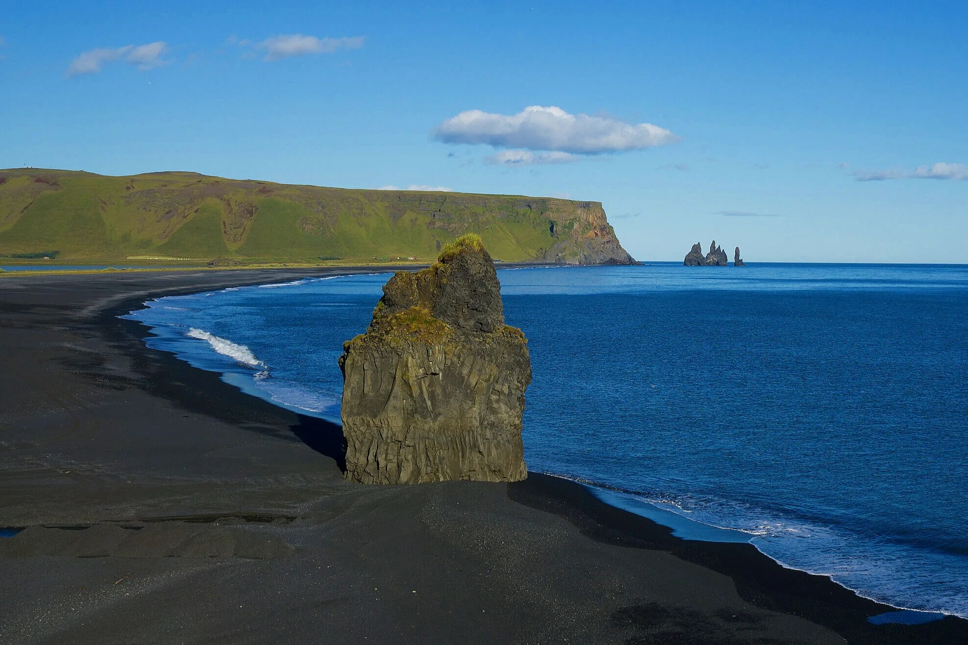
7. Dyrholaey Peninsula and Kirkjufara Beach

Even if you’ve never seen the name Dyrholaey before, you’ve probably already seen pictures. Dyrholaey is the famous rock arch along Iceland’s southern cost, and the Dyrholaey peninsula provides great views of the arch and of the moody Icelandic coastline, including the famous Reynisjafara black sand beach.
Getting here: To get here, you’ll hang on right off of the ring road onto route 218. At this point, you’ll be several hours down the ring road from Reykjavik. Route 218 is a paved road that ends in a gravel parking lot.
However, en route, you’ll pass an unpaved road on the right that leads you up to the top of the cliffside along the peninsula. This isn’t labeled as an F road, but there’s a sign at the entrance that labels it as a 4WD only. We didn’t have one at the time so we didn’t make it up this road, however it leads to an historic lighthouse and views of the Dyrholaey arch from the west and from a slightly higher vantage point (the famous shot you see everywhere).
If you pass this road, you’ll continue on the paved road and you’ll reach the main parking lot complete with fancy bathrooms (that you’ll have to pay for…so make sure you have some small krona or USD on you).
Here, you can walk around the rocky cliff side and take in views of the coast line. There’s also a trail that leads you up the cliff side to the viewpoint that the 4WD road takes you to. So, you can still get there, but with just a little more effort.
To the west is Kirkjufara, a narrow and short stretch of back sand beach. A path leads down to this beach, but it was closed when we were there in 2019 because of dangerous waves and rockfalls.
To the east is an excellent view of the famous black sand beach, Reynisjafara. In the distance, you can see Reynisdrangar, the iconic basalt sea stacks just off the shores of Vik (in our next two stops we’ll get a closer view of these).
The rocky cliff sides of this shoreline are also a great place for bird watching, and if you’re lucky enough to be there during the puffin nesting season in the summer, you’re likely to see some here (and we’re also very jealous)!

My favorite part of this stop, though, wasn’t the ocean views, but the views behind you. Looking back, you see the glaciated mountains of Iceland’s interior, and the contrast between the mossy green landscape with the white ice caps is quite a sight. We loved this stop along the ring road because it has it all!
8. Reynisjafara Beach

Reynisjafara is the famous black sand beach of Iceland and is a common stop on any ring road itinerary. It’s a huge stretch of black sand, and at the east end has the iconic and well photographed basalt columns.
Around the stacks is Halsanefshellir Cave, a hollowed-out portion of the stacks that forms a shallow cave in the sea side cliffs. During our visit, this part of the beach was closed to due dangerous rock fall just weeks prior, which brings me to my next point…
Iceland’s coastline is known for its so-called “sneaker waves”, which are pretty much exactly what they sound like. Every so often, a bigger than usual wave will “sneak” up on you, riding up the shore a little further and creating a large riptide back in to the Atlantic. They may have a silly name, but they’re no joke. They can be strong and unpredictable and even fatal, as they have caused some tourist deaths over the past several years. So as tempting as it may be, don’t go close to the water’s edge.

Getting here: Continue down the ring road until you see route 215 on the right. This paved road ends right at the parking lot for the beach, which also includes bathrooms and a restaurant.
With that said, the crowds here aren’t too bad. There are a lot of people, but it’s a big beach, and you can escape the crowds by venturing further west along the black sands. The main concentration of people hang out around the basalt columns.
9. Vik
Vik is quaint coastal village that is often a stopping point along the ring road for people to spend the night and to use as a base for exploring the nearby southern coast attractions. It’s also nice to just stop for a quick visit to explore the sights and culture. The Extreme Iceland website gives a good overview of everything Vik has to offer.
In addition to being a great area for birdwatching and potentially spotting some puffins, you can also visit Reynisdrangar View. This view brings you to a much less crowded black sand beach right in Vik and gives you a closer look at the three towering basalt columns just off the coast. To get a different perspective of Reynisdrangar, you can drive up the hill just to the west of Vik and look down over the cliff sides.
10. Hjörleifshöfði Cave
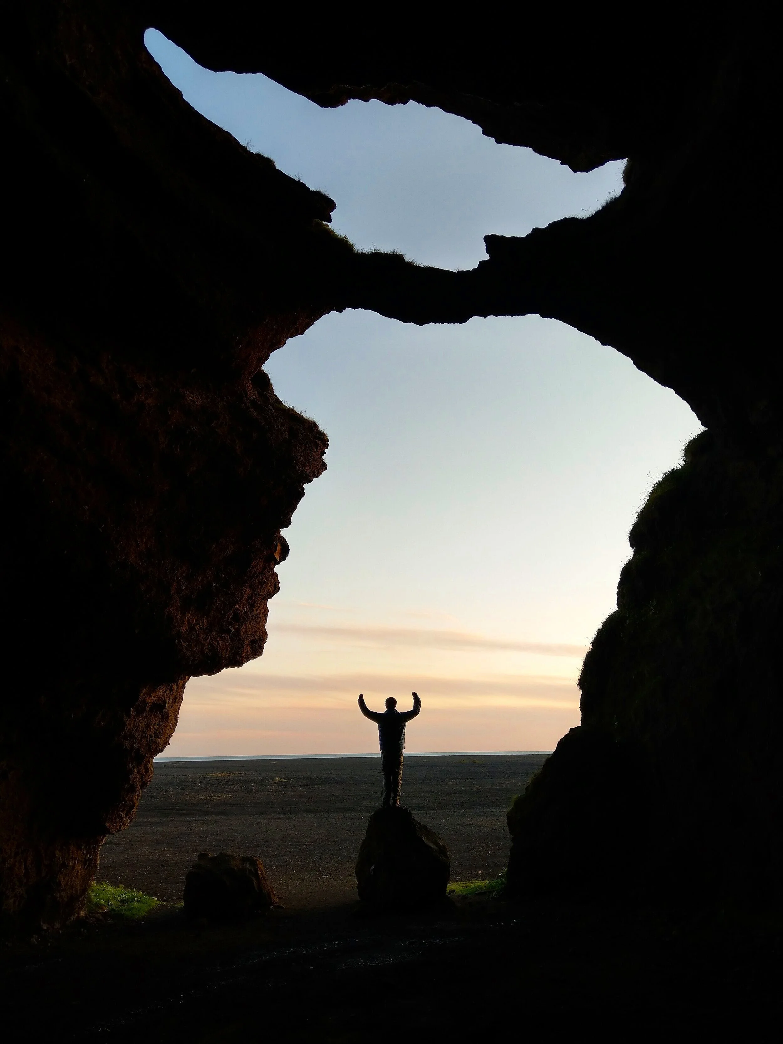
How do you even pronounce this?! Again, that’s how you know it’s going to be cool.
The Hjörleifshöfði Cave was something that I kind of looked into before going to Iceland, as in I knew it existed but I didn’t really make a concrete plan to go there and didn’t entirely know what it was or looked like. As we were driving the ring road past Vik, we saw the sign with this unpronounceable word on it, and made a snap decision to make the turn.
The road ended on an expansive beach where you can drive right up next to the cave. And we had this place all to ourselves!
We would say it’s worth the stop along the ring road. It’s a short drive, and the perspective you get from being inside the cave and looking out is really unique.
Getting here: About 10 minutes past Vik on the ring road, you’ll take a right-hand turn (there’ll be a sign with Hjörleifshöfði on it so you know you’re taking the correct road). The road is dirt and mildly rough, but definitely okay for a 2WD vehicle. About half way down the road there will be a small parking area to your left. This is not the cave, as we learned the hard way. Instead, it leads to a few hiking trails. Keep driving to the end of the road (only about 5 minutes) and you’ll end up right at the cave.
11. The Southern Coast Lava Fields
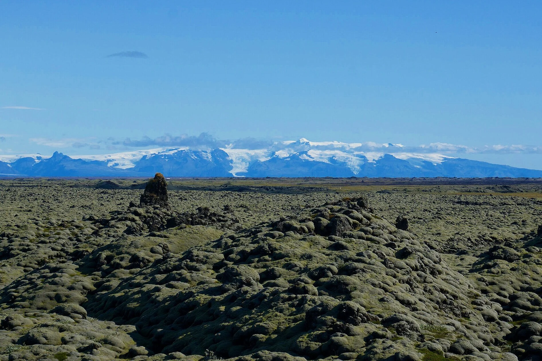
As you travel the ring road past Vik and make your way to the big glaciers of Iceland’s southern coast, the landscape around you gradually changes and you’ll find yourself driving through large expanses of lava fields. There’s a few differently named lava fields – Laufskalavarda, Eldhraun, and Brunahruan- but they all seem to just meld together as you’re driving along.
We never really saw signs for any one of them…you just start driving through them all of a sudden, but we did see various pull offs along the way. We finally stopped at one, and found a small parking area with short walking trails that take you through a tiny portion of the lava field.
12. Fjafrargljufar Canyon

Or as we like to call it, the “Justin Bieber Canyon”, because that’s way easier to pronounce, right?
The Justin Bieber Canyon was made famous by its feature in a 2015 Justin Bieber music video followed by a high degree of social media coverage. Since then, people have flocked to see this picturesque canyon, leaving it the latest victim to over tourism. The increase in foot traffic, especially in the muddier spring months, has increased damage to the oh-so fragile Icelandic vegetation, and now, the Environmental Agency of Iceland keeps the canyon closed for all but a few summer months to allow the vegetation time to grow and recover.
If you’re lucky enough to get to see this stunning canyon, please stay on the trail that follows the eastern edge of the canyon. It ends in a platform that gives you an awesome view back down the canyon and of a beautiful waterfall which pours into the stream that helped carved this canyon out for thousands of years.
It’s a popular stop along the ring road, but people sort of spread themselves out along the trail so we never felt like it was too overcrowded.
Getting here: This canyon is located just off the ring road, almost exactly half way between Vik and Skaftafell National Park (about an hour from each). The road is a smooth gravel road that will give 2WD cars no problem.
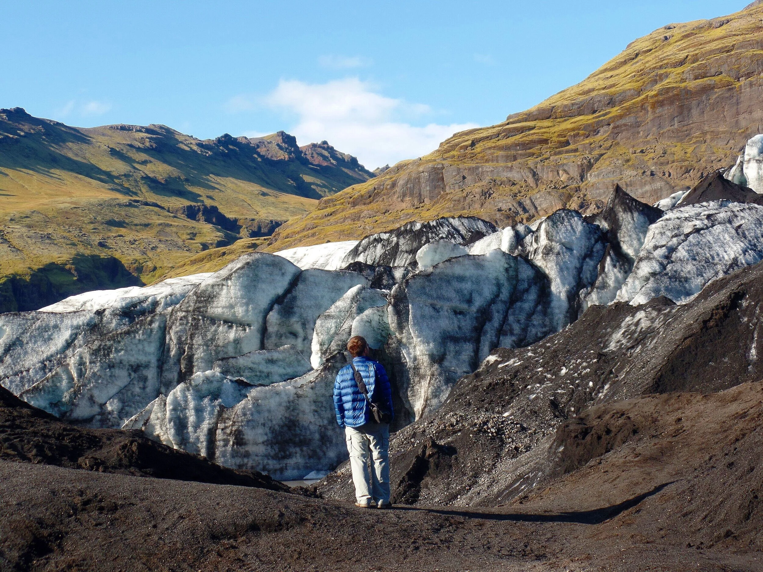
13. Skafatafell National Park

As you drive further east on the ring road, Iceland’s massive ice cap, Vatnajokull, will come into view, and as you get closer and closer, the views just get better and better.
Eventually, you’ll see cascading glacier after cascading glacier falling down the mountain sides, which are tongues of the much larger Vatnajokull. This is Iceland’s largest icecap, making up 8% of the entire country! It’s also Europe’s second largest and the world’s third largest glacier. Pretty impressive! And it’s the centerpiece of Iceland’s Skafatafell National Park.
The glacial tongues of Vatnajokull, such as Falljokull, Breidamerkurjokull, Svinafellsjokull, and Skaftafellsjokull are the main attractions of Skaftafell National Park, an outdoor enthusiast’s paradise.
A network of hiking trails allows you to get both up close and bird’s-eye views of these icy giants. Waterfalls flowing from the melting glaciers are also prominent, and the chance to possibly see reindeer and artic foxes is the icing on the cake (we weren’t so lucky).
There are several options to choose from when it comes to hiking in Skaftafell National Park, ranging from the easy stroll to the challenging climb, but we recommend the Svartifoss – Sjonarnipa Loop, a moderate hike that starts right at the visitor’s center and takes you past a famous waterfall, Svartifoss, formed by basaslt columns, and then to a breathtaking panorama overlooking the giant Skaftafell glacial tongue.


This hike is 7.5 km round trip with about a 1200 foot elevation gain, and took us exactly three hours at a relaxed pace and a long visit at the glacier viewpoint.
The Skaftafellsjokull trail is another recommended hike. This is a flat walk out to the glacial lagoon formed from the Skaftafell glacial tongue. This is better if you’re looking for an easier hike but still want to get some nice glacier views.
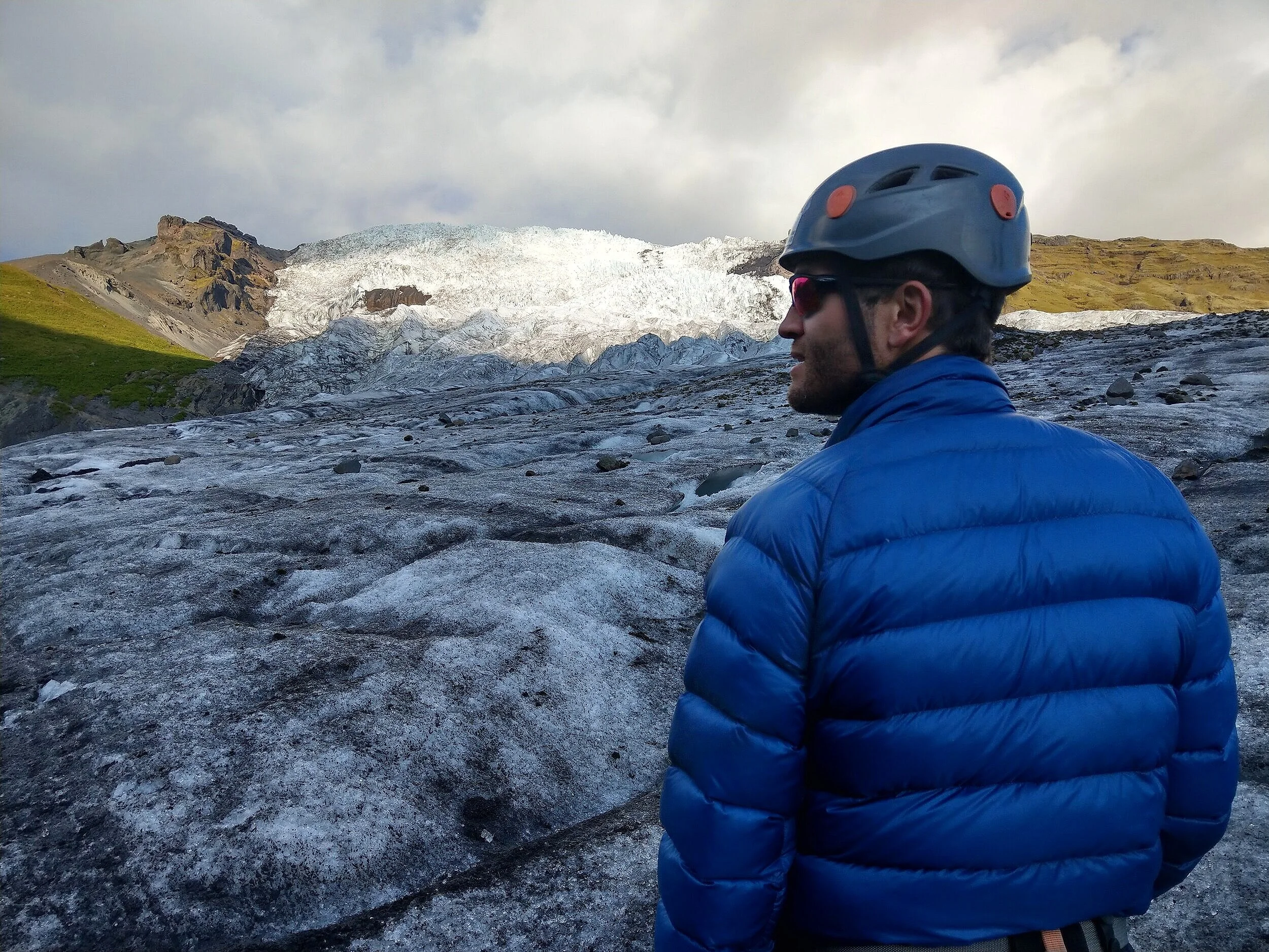
Aside from hiking, another very popular activity in Skaftafell National Park is glacier trekking. Strap on some crampons, grab an ice axe, and take a walk across one of the glacial feet. There are options that range from three hours to full day excursions.
This was our one splurge in Iceland and we’re glad we did it. It was fun getting up close to the glacial features and we learned a little bit about the geology of the glacier as well.
From late fall to early spring, you can also opt for ice cave tours and ice climbing as well.
Getting here: Driving along the ring road from the west, you’ll see a road to your left, route 998, that brings you to the Skaftafell parking lot after 2 km. Here, you’ll find a visitor center helpful information about the trails, a cafeteria, campground, and free bathrooms, though it will cost you to park for the day.
14. Svinafellsjokull

Just past the entrance road to Skaftafell National Park, you’ll find the road that brings you to Svinafellsjokull. This is yet another glacial tongue you can see from the ring road, but venturing out to this glacial lagoon and viewpoint is well worth the stop when driving the ring road.
The lagoon at Svinafellsjokull is infinitely less crowded than the more famous Jokulsarlon lagoon, but the high vantage view point over the glacier is spectacular.
Getting here: The road to turn off on from the ring road is on the left and marked by a sign. The road ends at a small parking area with no facilities.
A heads up: The road to get to Svinafellsjokull is an extremely rough gravel road! It’s not a F road or a 4WD only road, but it was in worse condition than some of the F roads we had been on earlier in our trip! It’s super bumpy and rocky. Expect a slow drive of about 10-15 km/h and for your car to get a little rattled. Make sure you have that gravel insurance! It was such a rough road that we some people that gave up, parked their cars along the side, and walked the rest of the way in.
15. Fjallsarlon Glacier Lagoon

For some weird reason that we can’t figure out, the Fjallsarlon Glacier Lagoon is another one of those incredible spots along the ring road that just isn’t on many people’s radar. But hey, no complaining here!
Getting here: About 40 minutes past Skaftafell National Park, you’ll see the turn off on your left for Fjallsarlon. A short paved road leads to a large parking lot with a restaurant and a boat tour office.
A short trail from the parking lot leads you to the base of the glacial lagoon, with the massive Fjallsarlon looming in the background. There are often icebergs floating across the lagoon, although the lake was pretty empty when we were there. Icebergs or not, the Fjallsarlon glacier is a beautiful piece of Iceland and one you should put on your ring road itinerary.
16. Diamond Beach

Just about 10 minutes or so down the ring road from Fjallsarlon is the famous Diamond Beach. Sparkling chunks of ice, both large and small, frequently get washed ashore on this black sand beach as they make their way from the Jokulsarlon Glacier Lagoon out to sea. The twinkling ice contrasting with the black sands is what gives this beach its name.
An added bonus – you’ll likely spot seals! These cute little guys like to bob around and play in the lagoon and close to shore, so keep your eyes peeled.
Getting here: As you drive the Ring Road, you’ll come to a small bridge with parking lots on either side. You can go to either side, but we thought the west side was more expansive with a longer shore of icebergs.
17. Jokulsarlon Glacier Lagoon

Finally, we’ve reached Jokulsarlon, perhaps one of Iceland’s most popular and famous tourist destinations, and usually the final stop for those just travelling along the Southern portion of Iceland’s ring road.
To be honest, I wasn’t too excited about going here, as the past week of traveling had me tired of the crowds- and I knew full well that this place would be super crowded. But, it was one of those things we felt like we just had to go to, just… because.
And…Crowded. It. Was, my friends. This was by far the most crowded place in Iceland we visited. The parking lot was a mad house and there were people everywhere!
With that said, the Jokulsarlon Glacier Lagoon is still a worthy stop along the ring road. It truly is spectacular.
Breidamerkurjokull, the glacier that feeds the lagoon, is set back well off into the distance, so you don’t ever get an up-close view of it. But the true star of the show here is the icebergs. The lagoon is filled with them, and pretty big ones, too, and you can occasionally hear and see them calving into smaller pieces that glide gracefully through the channel and out to sea.
There are walking paths that go along the coast and climb up to nice vantage points over the lagoon. Seals are a common sighting here as well!
Getting here: Parking for the lagoon is right across the street from Diamond Beach. Cross over the bridge and hang a left. You can’t miss it!
Best places along Iceland's East ring road

Jokulsarlon is the unofficial end of Iceland’s southern coast. Most tours stop here and return to Reykjavik, and if you venture beyond, you’ll leave the crowds behind. We were definitely ready to do just that after spending an entire week in the south.
The Eastern Fjords are much less visited, but, as with everything in Iceland, they’re beautiful. You’ll spend a large chunk of time weaving in and out of the fjords, following the coastline along rolling hills and sometimes precarious cliff side roads. The drive is beautiful, and often times reminded us of scenes from Montana (if you’re familiar with the Garden Wall of Glacier National Park, it was a little reminiscent of that).
Eventually, you’ll cut through a fjord via a 6 km tunnel and make your way up towards the north coast.
The weather was not on our side, and we didn’t have too much time to spend in the east fjords, making only brief stops here and there, but they have a lot to offer in terms of both natural beauty and cute coastal fishing villages.
18. Hofn
Hofn is a small Icelandic fishing town that marks the gateway into the Eastern Fjords. It’s an hour past the Jokulsarlon lagoon and a short drive off the ring road down route 99.
Hofn is often used a base for people wanting to explore the lagoon area for a few days, or as a resting point for those driving the ring road. It’s a good place to gas up and stock up on groceries (there’s a Netto in town). And of course, can’t complain about the gorgeous views back towards the glaciers.
19. Stokksnes

Stokksnes is a small peninsula just past Hofn. Here, you’ll find the insta-famous Vestrahorn, a prominent mountain jutting out into the sea.
Getting here: You’ll see the turnoff from the ring road on the right-hand side, just about 5 minutes past the turnoff for Hofn. It’s a ten-minute drive down a smooth gravel road that leads to a small parking area with a campground and a small restaurant called the Viking Café. It’s a very pretty drive with the glacial backdrop behind you.
There is an entrance fee of 900 ISK per person (not per vehicle) to drive the road to see the Vestrahorn. We decided to forego this one, but you can get some good views of the mountain from the east side as you continue driving along the ring road. Pictured above is the Vestrahorn from this perspective along the ring road as it juts out into the sea.
20. Random waterfalls and picnic areas

At this point, we’ll take a moment for a friendly PSA: Remember to not stick fiercely to any one ring road itinerary or plan!
As you drive the ring road, including through the East Fjords, you’re bound to see something cool or unexpected that you didn’t know about. Feel free to stop at one of the hundreds of beautiful random waterfalls and picnic areas to enjoy the views without all the crowds. There’s a lot of gems like these around the East coast… enjoy them!
21. Cute Coastal Fishing Villages
After leaving Hofn and weaving in and out of the fjords for three and a half hours, you’ll come to Egilsstadir, the largest town in East Iceland. It’s another great point to stock up on gas and groceries. There’s also a nice visitor center with a gift shop and tons of helpful information on places to go along the eastern fjords.
From Egilsstadir, you can venture off the ring road and down into one of the fjords to visit a quaint fishing village. The most well-known of the eastern fjord villages in Seydisfjordur, which is about a 30 minute drive weaving down through the fjord. Priding itself on being quirky and peculiar, it’s worth a visit to explore the colorful culture and food, take a walk on a hiking trail, or just take in the beautifully-snowcapped mountain scenery.
Another great coastal town to visit is Borgarfjordur Eystri. It’s a bit more of a trek to get to, about an hour detour from Egilsstadir, but if you come during the Icelandic puffin nesting season, then it’s worth a visit. This is named one of the safest places to view puffins in Iceland, as an extensive boardwalk system allows you to get up close to the puffin’s nesting grounds safely and without damaging their homes.
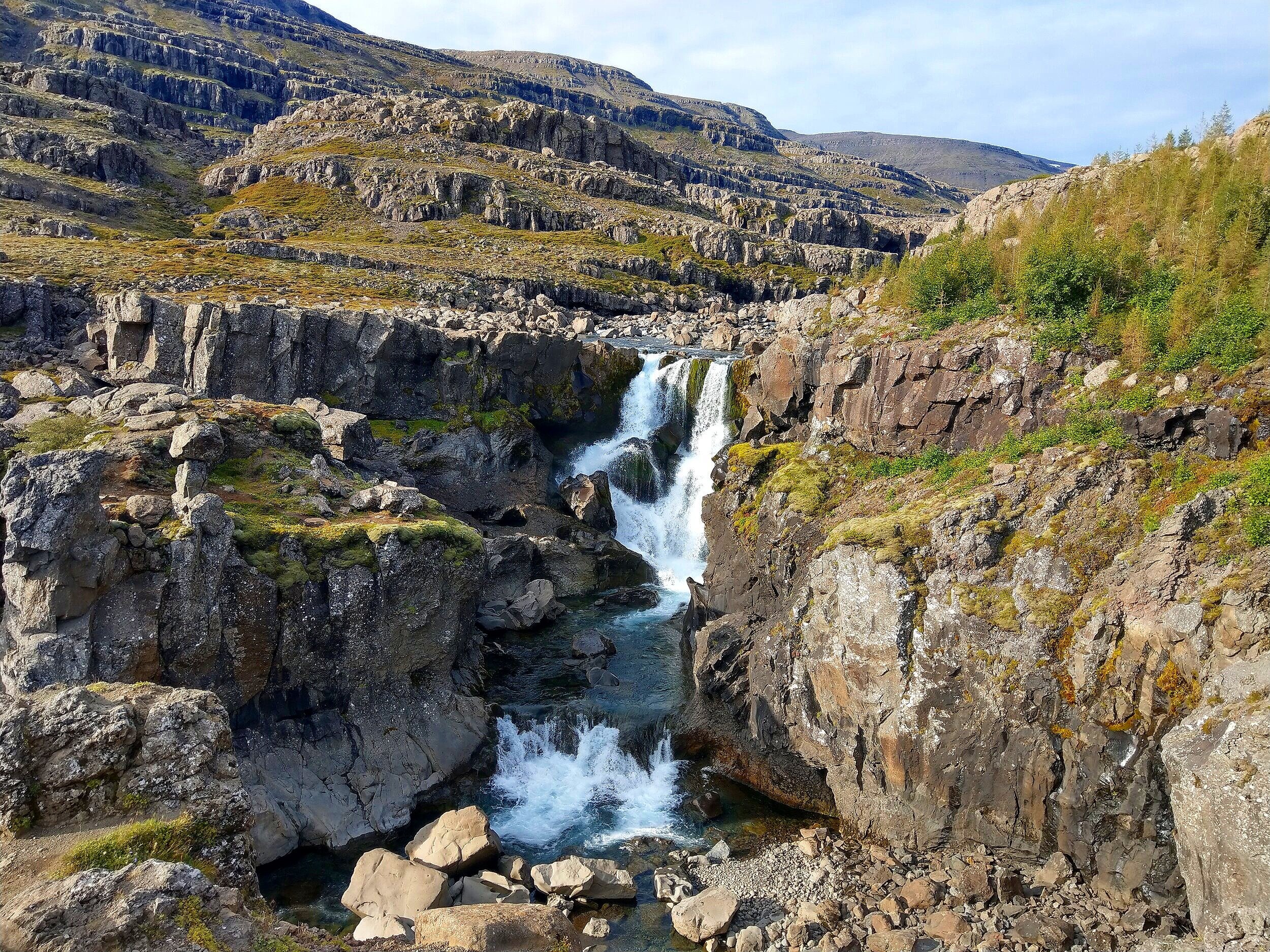
22. Hengifoss
Just a 30-minute drive from Egilsstadir, plus a 5 kilometer roundtrip hike, will get you to the third highest waterfall in Iceland. Its iconic feature is the thin layers of red clay sandwiched between thick rock layers, giving it a unique look, almost like it’s bursting with lava just underneath. We chose not to visit this one, but it’s worth taking a look to see if you want to add it to your itinerary!
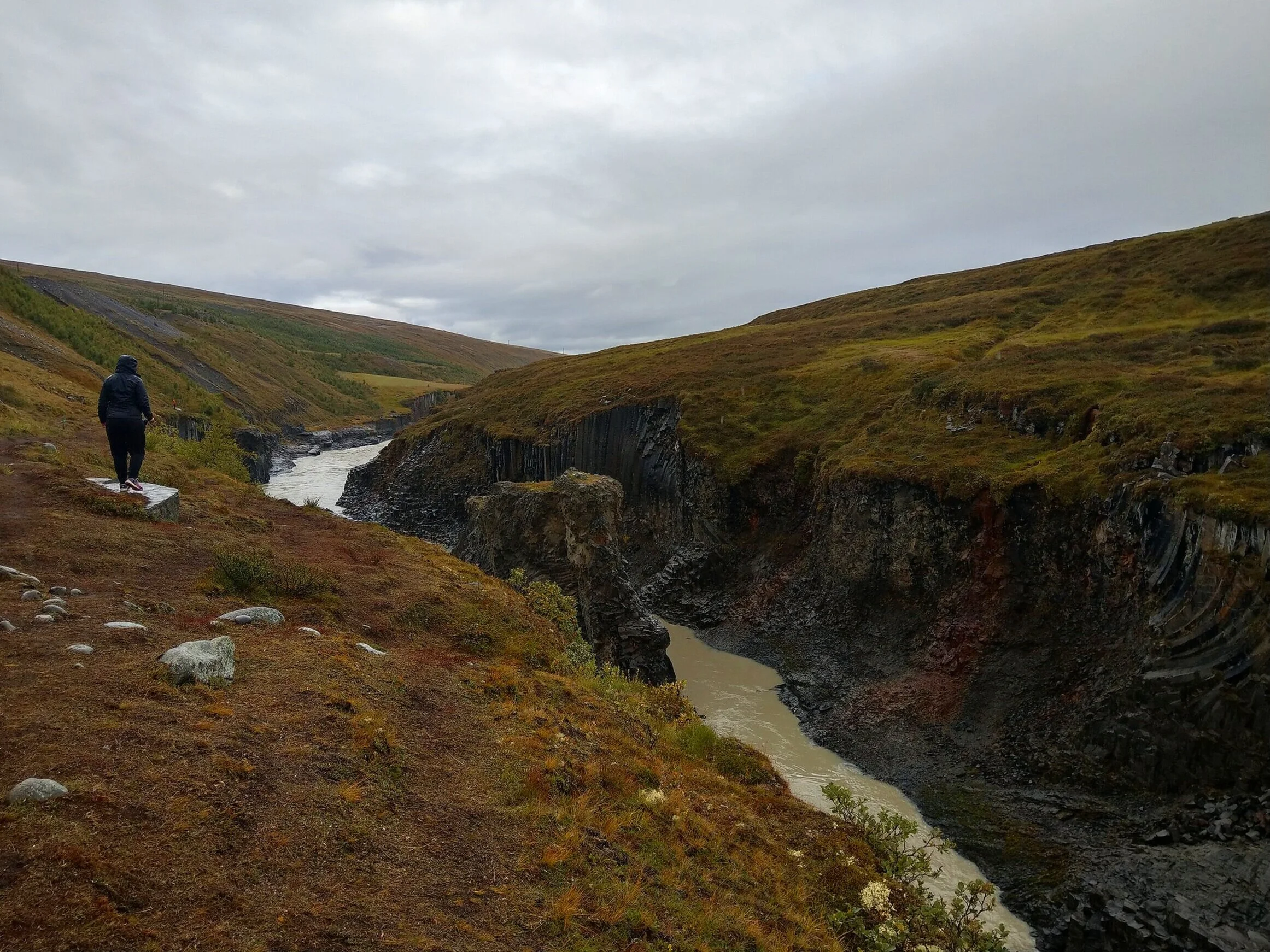
23. Studlagil Canyon

Studlagil Canyon is still considered an off-the-beaten -path hidden gem in Iceland. And while it is indeed a little off-the-beaten-path, it’s quickly becoming more popular. In fact, we learned about this destination during a quick scroll through social media!
In pictures, Studlagil is a very scenic canyon of basalt rock. It is a true feat of nature, carved from the forces of melting glacial water that left behind a stunning canyon lined by towering basalt columns and filled by a blue glacial river.
But, here’s where we tell you what NOT to do.
Before visiting Iceland, Studlagil was on my radar, but for some reason I thought we would need a 4x4 vehicle to visit it, and so I made no concrete plans to visit nor do any deep research into getting there. When we were in the visitor center at Egilsstadir, though, I learned that it is in fact accessible by 2WD, so I plugged it into our GPS, and off we went!
The problem with this is that you really need to know in advance where to go and how to get there. There are pretty much no signs at all marking where to go as you’re driving, and there’s actually 2 ways to view the canyon. The east is the side where you can actually get down into the canyon and get “the” shot. From the west, you can only view the canyon from above, standing on precariously rocky trails. The GPS will take you to the west side viewing location.
Getting here: To get to either the west or east side, you start by driving the ring road north from Egilsstadir, and after about 45 minutes you’ll see a left-hand turn for route 923. Turn here and soon after, you’ll see another left onto a dirt road that goes towards Jokuldalsvegur. This road is a bit rough as it follows the cliff side, and keep your eyes out for sheep! There were quite a few times where we had to make quick stops to avoid them in the middle of the road.
The west viewpoint: The GPS had us follow this road for 18 km, after which you’ll see a parking area to your left with an informational sign and a donation box. From here, there’s a very precarious, loose, rocky, slippery (it didn’t help that it was lightly raining at the time) path that brings you to two different view points above the canyon. There are a couple of sloping points along the trail with loose dirt and ropes that you can hold onto.
Honestly, the views were okay from here, but not what we were expecting, and the trail was a little terrifying. And maybe it was because it was a dreary day, but the blue glacial water didn’t look so blue. It looked more murky gray.
The east viewpoint: To avoid our mistake, instead of driving 18 km to this parking area, you’ll stop at about kilometer 14 and pull into a farm called Klaustursel. You can park here, and then walk across a bridge to the east side. The path all the way to the canyon is 8 km roundtrip. About half way through you’ll get up close to the Studlafoss waterfall, which can be seen as you drive along the west side as well.
Our thoughts: Overall, we would say going to the west side by itself isn’t worth the detour from the ring road, but if you’re up for a hike and have the time, visiting the east side is a good option for an off-the-beaten-path adventure in Iceland.
Best places along Iceland's northern ring road

As you make your way into the Northern reaches of Iceland’s ring road, the scenery changes yet again. You’re no longer following the coastline, but instead making your way across a dark, barren, volcanic landscape.
The changing scenery around the ring road never gets old, even though you might be driving for hours at a time between stops… and to get to the first stop along Iceland’s Northern coast, you’ll be driving for about two hours from Egilsstadir.
24. Dettifoss and Selfoss

Dettifoss, pictured above, is probably the most popular attraction along the northern section of Iceland’s ring road, though it still doesn’t come close to the crowds found in the south. Considered Europe’s most powerful waterfall, it’s worth the 20 minute detour off of the ring road.
Selfoss is a smaller waterfall found just upstream from Dettifoss, but what it lacks in power it makes up for in beauty. Instead of one large waterfall, it’s really a series of smaller waterfalls stretched out across the canyon.
Both Dettifoss and Selfoss are formed from the powerful melting waters from Vatnajokull. They can be reached from both the west and east sides.
Getting to the west side: The west side of both waterfalls is the easiest option in terms of driving. About an hour and 40 minutes past Egilsstadir on the ring road, you’ll come to the turn on the right for route 862. Follow this paved road for 20 minutes until you see the Dettifoss parking lot. The lot has a visitor center and free bathrooms.
The walking trail to Dettifoss is well marked and short…less than one kilometer. You’ll come to a viewpoint where Dettifoss and its canyon first come into view. From here, you can walk down a short but steep stone path to get up close to the powerful falls. Or, you can continue along to a higher vantage point further down.
Either way, you’ll get wet. There’s tons of spray from the falls so you’ll be much more comfortable if you wear waterproof clothing and good shoes for walking around slippery rocks.
Along the trail to Dettifoss are several well-marked branch points that will take you to Selfoss only about a half a kilometer away. From the west side, you don’t get a straight shot of these falls, but rather a look up the length of the canyon down which all the small cascades are streaming. It’s quite a unique perspective.
The entire trip to visit both falls is about 2.5 kilometers.

The east side: The views of each fall from the east side are slightly different, and both the road and walking paths to get there are a bit more rugged. Instead of heading down route 862, take a right onto route 864 off the ring road. This is a smooth gravel road that is passable with a 2WD car and will lead you to a small parking lot after about 40 minutes of driving.
The path to view Dettifoss is a bit rockier than the path from the west side. You don’t see the fall straight on like you do from the west side, but here you can get right up next to the top of the falls.
Similarly, the path to Selfoss is much rockier and less defined than the west side trails, but the view to Selfoss is straight on, and you can see all the cascades running along the river wall.
Iceland’s Diamond Circle: Dettifoss is part of the recently established Diamond Circle, Iceland’s northern counterpart to the Golden Circle. It’s a short 162 mile loop that takes you through some of the best attractions and landscapes the north has to offer, including many spots on this list. It includes Dettifoss and Selfoss, Lake Myvatn (described below), Asbyrgi Canyon (a uniquely forested canyon), Godafoss (described below), and Husavik (known as the whale watching capital of Iceland). If you’re looking for more to do on Iceland’s northern coast, the Diamond Circle is it!
25. Namaskard Geothermal Area

As you drive further along the northern ring road, you’ll enter what’s known as the Lake Myvatn area. Located just an hour from Dettifoss, Lake Myvatn is a giant volcanic lake surrounded by lava fields and high geothermal activity. It’s the heart of the northern ring road, and includes many of the north’s popular attractions and ring road pitstops.
The Namaskard Geothermal Area, also called the Hverir geothermal area, is the first stop of several in the Lake Myvatn area. It’s located just a few kilometers before reaching Lake Myvatn itself and is a colorful display of Northern Iceland’s prevalent geothermal activity.
A small trail system weaves through bubbling mud pits and steaming vents, all of which lie in the shadow of Mount Namafjell, the prominent ridge in the background. There are actually a few ways to climb this small mountain, some steeper than others, but all leading to a view over the entire geothermal area, and to some mountain top steam vents as well.
26. Myvatn Nature Baths
A smaller, supposedly less crowded version of the Blue Lagoon, the Myvatn Nature Bath is a geothermal pool whose water is provided by a nearby geothermal plant (i.e. like the Blue Lagoon, it’s not a natural hot spring).
These nature baths are for anyone traveling the ring road and looking to get a Blue-Lagoon-like experience for about half the price. The turn for the Myvatn baths is right off the ring road, just a few kilometers down from Namaskard.
27. Grjotagja Hot Spring Cave

This is a very quick stop but it’s pretty unique.
Grjotagja (how do you say this?! Again, Icelandic pronunciations allude us…) is a cave formed from cooled lava that contains a hot spring inside.
When parking, it seems almost anticlimactic, as the cave is right next to the parking lot and has a tiny opening to walk through, but it’s actually pretty cool inside with its crystal clear blue water and almost mystical quality. You can’t swim in it, but it’s still a neat place to make a quick visit.
Getting here: Just a few kilometers pass Namaskard as you approach Late Myvatn, you’ll take a left onto route 860. This is a well-groomed dirt road. The tiny parking lot will be on your left after 2 kilometers. There are two entrances to the cave, right next to the lot.
28. Dimmuborgir

Located along Lake Myvatn, Dimmuborgir is a large collection of unique lava formations, including towering pillars and dramatic arches that makes for a fun stop off the ring road.
Several trails weave their way through the formations, ranging from easy and short to long and challenging. A map at the parking area outlines each of the trail options.
One of the longer trails summits Hverjfall, a giant volcanic crater seen in the distance. (There’s also an easier and quicker route up to the top of the crater from a parking lot that sits right next to it. This can be found off route 848, just before the parking lot for Dimmurborgir.)
Getting here: Route 848 is a paved road that detours off the ring road and encircles Lake Myvatn. A few kilometers up on the left, you will see a left-hand road with a sign that directs you to Dimmurborgir. The road ends at a parking lot with a restaurant and the trailhead.
29. Viti Crater (Krafla)

The Viti Crater in Krafla is found up the road that lies almost exactly across from the Namaskard geothermal area. This road passes through the Krafla geothermal power plant, which is how you know you’re heading in the right direction, and after ten minutes ends at the small parking lot for Viti Crater.
You’ll park right AT the crater, no hike required! In just a few steps, you’ll be standing in front of a bright blue volcanic lake at the bottom of a crater. Pretty cool! The best part is, not many people visit here, so it’s still kind of a hidden gem.
Important Note! This is not to be confused with the Viti Lake in Askja, which requires a 4x4 vehicle to get to. We didn’t visit this one as we didn’t have a 4x4 for this leg of our trip, but it is worth looking into if you do have the right vehicle!
30. Godafoss
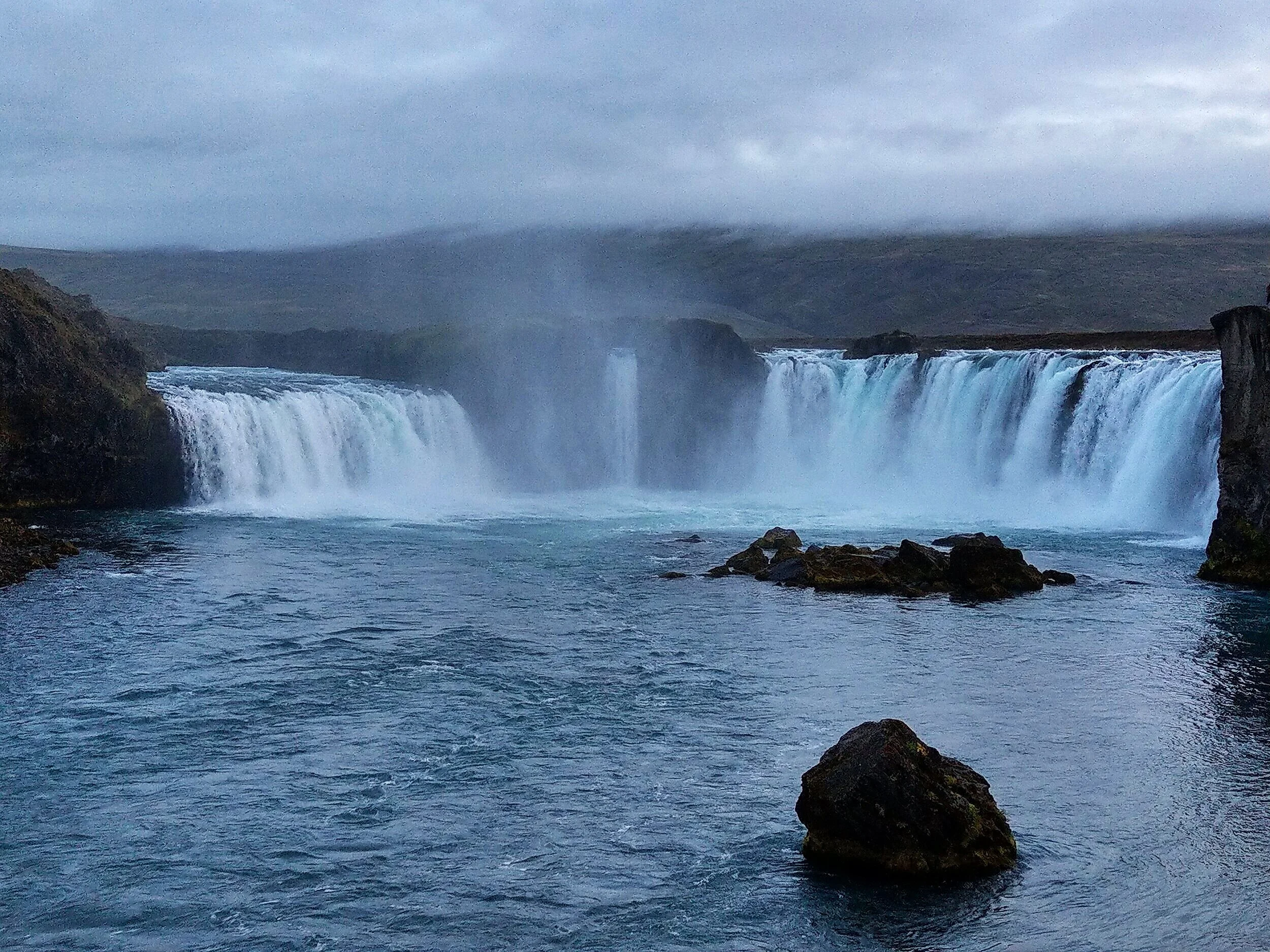
Godafoss is another picturesque horeshoe-shaped Icelandic waterfall that is a quintessential stop on any ring road itinerary. You can view this waterfall from either the west or the east side.
Getting here: The parking lot for the west side of Godafoss is right off the ring road on the left, about 45 minutes past Lake Myvatn. A short walking trail will take you right up next to the falls.
If you’d like to see Godafoss from the eastern side, take left onto route 844 to Fossholl and shortly down the road there will be another parking lot. The walk to the fall is only slightly longer from this side.
31. Akureyri

Considered the capital of the North, Akureyri is the major city along the northern coast of Iceland. Here, you’ll be just 60 miles away from the Arctic Circle! Pretty neat!
Apart from serving as a base for traveling to all of the northern attractions in Iceland mentioned above, the city itself has plenty to keep anyone busy for a few days.
We just drove through this town in our quest to see as much as we could on the ring road, but check out these sites for things to do in Akureyri if you want to stick around longer: adventures.is, Iceland Monitor, Extreme Iceland, and Visit Akureyri.
Best places along Iceland's west ring road
As you drive the ring road beyond Akureyri, you leave behind the northern coast and venture into Western Iceland.
Admittedly, we did not spend very much time along this portion of the ring road, because, well, there aren’t very many stops here. But, while there is little in terms of natural attractions right along the ring road in western Iceland, the drive itself is still worthy of your time as the scenery is still gorgeous as ever, and, well, you gotta get back to Reykjavik, right?
Your main option on Iceland’s western coast is to make day trips off the ring road and venture into places like the remote Westfjords, or road trip through the Snaefellsnes Peninsula, which we talk about more below.
But along the ring road, there is one attraction worth noting here.
32. Glymur Falls
Only 30 minutes from the ring road between the Snaefellsnes Peninsula and Reykjavik lies Iceland’s second highest waterfall, Glymur Falls. A mildy challenging 4.5 mile hike takes you to a viewpoint overlooking the falls.
We didn’t get the chance to do this one, and by the time we got to this point along the ring road, we were a little waterfalled out to be honest. We didn’t think that could happen, but trust us, there are sooooo many waterfalls in Iceland that it might happen to you, too!
Check here for a pretty comprehensive guide of Glymur Falls, including how to get to it and what to expect.
Iceland Ring Road Itinerary Suggestions
So we’ve hit you with a lot here, because, well, there are tons of awesome stops along the ring road! But, you might be thinking, I don’t have months to visit this country! So…
How long do you need to drive the ring road in Iceland?
Good question! It really all depends on what and how much you want to see.
But, we would say that an absolute minimum of 6 days is required to see all 32 spots on this ring road itinerary. A one week Iceland ring road itinerary would look something like this:
Three days to cover all the spots along the south coast
Day 1: This will be your “Waterfalls Galore” day, starting in Reykjavik and heading toward Vik, hitting all the waterfalls in between… Glugafoss, Seljalandsfoss, Gljufrabuifoss, Kvernfoss, and Skogafoss. Phew, that’s a lot! Stay near Skogar or continue to Vik to spend the night.
Day 2: This day is all about those black sand beaches! Explore Vik, Dyrholaey and Reynisjafara. Then start heading further east, making a stop at Fjafra-, no, the Justin Bieber (much easier!) canyon on your way to Skaftafell National Park. Spend the night in or near the park.
Day 3: Explore Skaftafell National Park in the morning by taking a short hike and admiring all those glacier tongues cascading down along the ring road. Drive towards the glacial lagoon area and hit up all the best spots… Svinafellsjokull, Fjallsarlon, Diamond Beach, and Jokulsarlon Glacier Lagoon. Spend the night in Hofn.
A day to traverse through the eastern fjords just hitting one or two quick stops
Day 4: Weave your way from Hofn through the Eastern Fjords, enjoying the scenery, and if time allows, make a stop or 2, possibly to Hengifoss or Studlagil.
One day to spend seeing the sites on the northern coast
Day 5 morning: Visit Dettifoss and Selfoss
Day 5 afternoon: Visit the sites around Myvatn Lake. Spend the night in Akureyri.
One more day to get back to Reykjavik driving down the western side
Day 6: Drive from Akureyri to Reykjavik, with a stop to hike Glymur Falls.
As you can imagine, squeezing 32 stops into just 6 day might seem very rushed. Plus, it gives you no time to spend exploring Reykjavik or any of the other cute towns you’ll pass through with sufficient time.
If you’d like a slightly more relaxed road trip, with time to drive into and explore coastal villages, we would say 9 to 10 days is a more comfortable time frame to drive the entire ring road. A 10 day Iceland ring road itinerary would look similar to the itinerary outlined above, but with the following additions:
Having two days on the east coast would be nice to drive into a fjord and explore a town such as Seydisfjordur, and maybe do a short hike as well.
An extra day or two on the north coast would be nice as well. The north coast covers a long stretch of road, plus includes the Diamond Circle, so having adequate time to explore everything along the way and to maybe include an activity such as whale watching out of Husavik would be ideal.
Or, you can put an extra day on the south coast to do an activity such as glacier hiking in Skaftafell.
Exploring the ring road with less time
The bad news: If you have less than 6 days to spend in Iceland, then driving the entire ring road probably isn’t possible, unfortunately, unless you don’t mind feeling super rushed and skipping through lots of things.
The good news? You can still see some pretty awesome stuff even if you don’t drive the ring road!
Iceland in 3 days or less:
If you’re in Iceland for 3 days or less, which is common as many people visit Iceland on a stopover in route to another country, we think the south coast is the way to go.
A lot of people suggesting spending a long weekend in Iceland in Reykjavik and the Golden Circle, but we think the south coast is 100 times more epic and scenic, and showcases things that are way more unique to Iceland than the Golden Circle does.
Iceland in 3-6 days:
With more time in Iceland, between 3 to 6 days, we would suggest sticking to the southern coast and adding on the Snaefellsnes Peninsula and/or the Golden Circle, based on your interests and whatever looks most appealing to you. We’ll talk about these two additional places below!
What to do with 10 days or more in Iceland
Are you planning a trip to Iceland for more than 10 days and have time to explore more than just the ring road? Lucky you!
Though it’s a super popular thing to do here, there is so much more to Iceland than just driving the ring road. We have some suggestions for you here about how to spend your extra time! No matter what you choose, it is sure to promise epic scenery and adventure!
Worthy detours off the ring road
Check out some of these awesome places you can get to off the ring road as a day trip (or longer, if you want!). Some of these are still pretty touristy, but others are a bit off the tourist trail.
The Golden Circle

If you’ve done even just the slightest bit of research in planning your Iceland trip already, I’m sure you’ve at least heard of Iceland’s Golden Circle.
This is one of Iceland’s most popular routes due to its accessibility from Reykjavik, the possibility to do it in just a day, and the wide range of natural attractions that you can find along the way. The whole loop can be driven from Reykjavik in just about 3.5 hours, but it will likely you take you the entire day since there’s so much you’ll be stopping to explore, from waterfalls to geysers to hot springs to craters.
Time added to ring road itinerary: One day
The Snaefellsnes Peninsula

The Snaefellsnes Peninsula protrudes from the western coast of Iceland and starts just about an hour and a half away from Reykjavik. The crowds here aren’t as heavy as you’ll find along the southern coast, but don’t expect complete isolation either.
Known as the home for the most famous photographic spot in Iceland (Mount Kirkjufell, pictured above), the Snaefellsnes Peninsula has so much more. In fact, it is often called “Iceland in Miniature” because of the diversity of landscapes you can find by just a quick drive around its perimeter. It’s almost like doing a very short version of the ring road!
Time added to ring road itinerary: A full loop of the peninsula can be done in just 3.5 hours but you’ll likely be making enough stops that a full day is required at the bare minimum. We spent an entire day here and felt slightly rushed, passing by things we had on our list due to lack of time. To explore everything, two days would be ideal, but if you can pick and choose a handful of things, the entire peninsula can be driven easily in a day.
The West Fjords

Ah, the West Fjords of Iceland. If you’re not yet familiar with these, there’s a good reason for that.
The West Fjords are that huge protrusion from the mainland in the northwestern corner of the country, and happen to be the least visited and most remote part of Iceland.
The West Fjords are a long drive from Reykjavik. Heck, it’s even a long drive off the ring road! As an example, to get from the nearest point of the ring road out to the tip of the southern portion of the West Fjords is a 3.5 hour drive one way.
Further, the roads in the West Fjords are known to be notoriously rough and a bit dangerous. Despite the recent paving of a lot of roads within the Westfjords, there are still a number of gravel sections and roads that pass over and down mountain passes.
But, if you’re willing to make the drive and you have the extra time, you’ll be rewarded with the most isolated places you can get in Iceland, at some pretty epic destinations like red sand beaches, dramatic cliff sides with large puffin colonies, and crazy waterfalls. The northern Westfjords is also home to the super remote and isolated Hornstrandir Nature Reserve, which has no roads, accommodations or services, requiring you to be totally self-sufficient!

Time added to ring road itinerary: A visit to the Westfjords will require a minimum of two days. Trying to drive out, make some stops, and drive back to the ring road all in one day is possible, but won’t be enjoyable and would require 6 hours or more of vigilant driving. We drove into the fjords in the morning, spent the afternoon exploring, spent the night camping, and then drove back to the ring road the next morning, and even that was a bit much!
The Icelandic Highlands
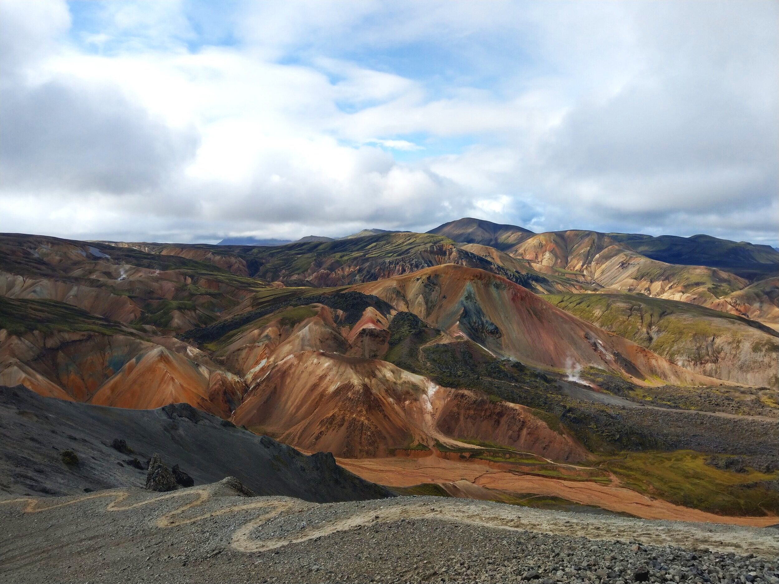
The highlands of Iceland look like something from out of this world. Colorful rhyolite mountains, hotsprings, and moss-covered volcanoes rising from a sea of black sand…sound fake? Well, it isn’t!
If you want to see this unique landscape and even hike around it, Landmannalaugar in the Icelandic highlands is the place to go. The highlands are located in the interior of the country and are accessible only by rough isolated F roads that absolutely require a 4x4. If you rented a 4x4 vehicle, you can easily add Landmannalaugar as a day or overnight trip to your ring road itinerary.
Time added to ring road itinerary: You can drive here, do a short hike, and drive back to the ring road in one day, but it will be a long day with a lot of rough driving. We suggest staying overnight in Landmannalaugar to make the most of your time here.
The Reykjanes Peninsula
If you flew into Iceland, you’ve already been here!
The Reykjanes Peninsula is a tiny peninsula in the southwestern part of Iceland that houses the Keflavik airport. You’ll drive down the western edge of the peninsula to get to Reykjavik, so on your way to or from the airport, why not make a few pitstops along the way?
Despite being well traveled from airport goers, not many people know to explore the peninsula any further, and chances are you’ll find few other people if you decide to make the quick detour.
The Reykjanes Peninsula is very volcanic and consists of large lava fields, lots of geothermal activity, and little vegetation. It’s also home to the famous tourist attraction, the Blue Lagoon, which is fed from a nearby geothermal power plant.
While driving through the peninsula, you can play in lava tubes, gaze into volcanic craters, walk along beautiful blue lakes, like Kleifarvatn, and visit geothermal springs such as Krysuvik.


Time added to ring road itinerary: A half day is enough to explore the highlights of this peninsula!
Have questions?
And that’s a wrap! We showed you what we think are some of the best stops along Iceland’s ring road, and we really hope this guide gives you some inspiration to make road tripping a part of your visit to this amazing country and helps you plan your own Iceland ring road itinerary. If you have any questions or things to add to the list, comment below! We’d love to hear from you.
