How to hike Wheeler Peak in Great Basin National Park (Map, Tips, and More!)
Looking for a challenging hike in Great Basin National Park? Look no further than Wheeler Peak. Wheeler Peak is one of the tallest peaks in Nevada and is a steep and rocky climb to a 13,000 foot summit. It’s definitely a hike you want to be prepared for, and in this guide, we’ll go over everything you need to know to hike Great Basin’s Wheeler Peak in Nevada, from how to get there, when to go, what to expect on the trail, and more.

Great Basin National Park in Nevada was a huge unexpected surprise for us. There were so many unique things to do, like exploring caves, experiencing some amazing stargazing, walking among some of the world’s oldest trees, and best of all, hitting the trails on some amazing alpine hikes. We had no idea that rising thousands of feet above the Great Basin desert was this whole other alpine world filled with beautiful lakes and jagged mountain scenery.
There are a few really amazing hikes in Great Basin that are on the easier side, like the Alpine Lakes Loop and the Bristlecone-Glacier Trail, that take you to some amazing views and places, but if you are looking for a real challenge with an epic reward at the top, then consider the hike to Wheeler Peak.
Wheeler Peak is the mountain that dominates the Great Basin skyline. As you drive towards the top of the Wheeler Peak Scenic Drive – the main road in the park- and do any of the smaller hikes in the area, Wheeler Peak rises sharply in the background. It’s not to be confused with Wheeler Peak in New Mexico, the tallest peak in that state, but this Wheeler Peak in Nevada, at 13,063 feet, is also kind of the tallest peak in Nevada, too. We say kind of because there’s technically another peak, Boundary Peak, that’s considered the high point of the state. But Boundary Peak, as the name implies, lies right on the border between Nevada and California, so while the summit itself is in Nevada, the entire mountain is shared with California, leaving Wheeler Peak to be the highest point that lies completely in the state of Nevada. So, if after summiting Wheeler Peak you want to say you’ve been to the tallest point in Nevada, we won’t stop you! You’ll deserve it after making this climb!
And a climb it is…the hike to Wheeler Peak in Great Basin National Park is definitely a challenging one. The hike starts off deceptively easy, but the last few miles are very steep and very rocky. Not to mention, this is all being done at high altitude, which just adds to the challenge. For this hike, you’ll want to come prepared…for the challenge, the altitude, and the elements.
In this guide, we’ll go over everything you need to know to hike Wheeler Peak in Great Basin National Park in Nevada. You’ll learn what to expect on the trail, different route options, what to pack, and get all our best tips. So, let’s get to it!
In this Wheeler Peak, Nevada hiking guide:
Where is the trailhead for Wheeler Peak in Great Basin National Park?
Hiking Wheeler Peak in Great Basin National Park: Our experience
Where to stay near Wheeler Peak in Great Basin National Park
Other tips for hiking to Wheeler Peak in Great Basin National Park
More things to do near Wheeler Peak in Great Basin National Park
Where is the Trailhead for Wheeler Peak in Great Basin National Park?
There are actually two possible trailheads for Wheeler Peak in Nevada. Both lie at the end of the Wheeler Peak Scenic Drive in Great Basin National Park.
This scenic drive is about 12 miles long where it starts near the Lehman Caves Visitor Center and climbs over 3,000 feet as it winds its way up the Snake Mountain range. Expect to take at least 20 minutes to drive to the top, as its winding nature will mean you’ll have to take it pretty slow.

A view of the Wheeler Peak Scenic Drive in Great Basin
Just before you get to the end of the road, you’ll see a small parking area to the right for the Wheeler Peak Summit Trailhead. This is the first of two possible starting spots for the hike to Wheeler Peak.
If you continue down the scenic drive, the road will end just before the Wheeler Peak Campground at the Bristlecone Pine parking lot. This is a much larger lot and is the starting point for all other hikes in this area (the Alpine Lakes Loop, Bristlecone Pine Trail, Glacier Trail, and Island Forest Interpretive Trail). This is also another starting point for the Wheeler Peak hike. You’ll start off counterclockwise on the Alpine Lakes Loop for a bit and then just before reaching Stella Lake, you’ll branch off onto the Wheeler Peak Summit Trail.
So, which Wheeler Peak trailhead should you use? Well, if you start from the Bristlecone lot at the end of the road, this will cut off about 0.8 miles from the hike, making the hike from this trailhead the shortest hike to Wheeler Peak. However, it adds nearly 200 feet of elevation gain.
The Wheeler Peak Summit trailhead starts at the highest point along the Scenic Drive, so it eliminates some of the climb on the trail. It’s not much in the grand scheme of things, but it’s something. And although the Wheeler Peak Summit trail is a little bit longer, we thought it was a really nice walk and a good warm up for the hike ahead, as the beginning portion of the hike was pretty flat and easy for the first mile before it meets up just briefly with the Alpine Lakes Loop and then continues on the Wheeler Peak Summit Trail up to Wheeler Peak.
For us, we started at the Wheeler Peak Summit Trailhead, mostly because we just wanted some different scenery, as we had hiked the Alpine Lakes Loop just the day before. Plus, we wanted to stay away from the “crowds” of the larger main lot, which gives access to all the trails in this area (I say crowds relatively here, as Great Basin is still one of the least visited parks in the country!).
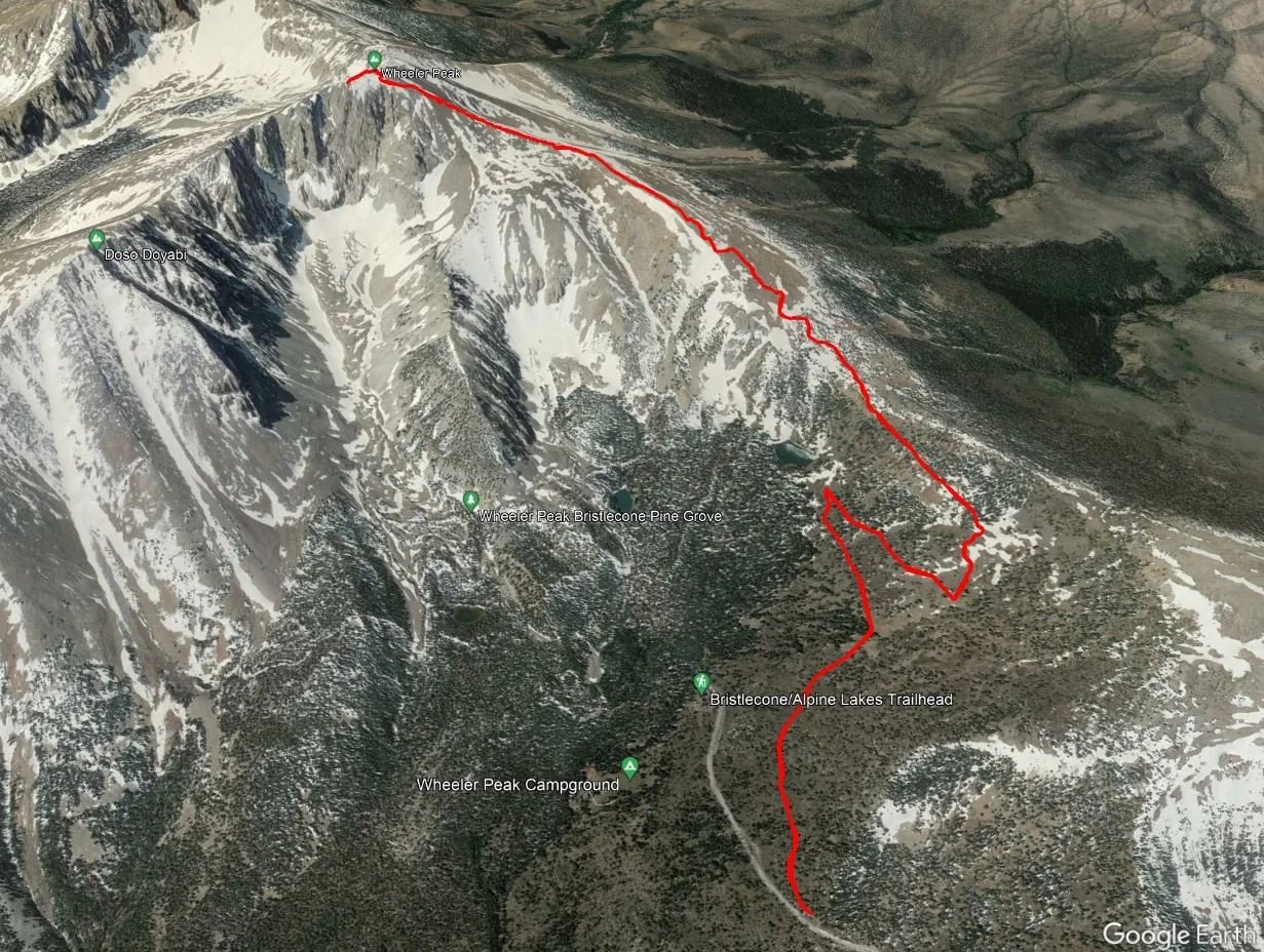
Wheeler Peak, Nevada trail map
Here’s a trail map of Wheeler Peak in Nevada to get you oriented to where the two trailheads are.

This trail map of the Wheeler Peak area shows the two possible trailheads for the Wheeler Peak hike. You can start at the Wheeler Peak Summit Trailhead and hike the Summit Trail (red), or you can start at the Bristlecone-Alpine Lakes Trailhead and hike the blue trail until it meets up with the summit trail.
Hiking Stats for Wheeler Peak in Great Basin National Park
Since we started from the Wheeler Peak Summit Trail, we’ll give you the stats for this version of the Wheeler Peak hike. If you start from the Bristlecone Lot, just shave off about .8 miles and add about 200 feet of gain to the overall hike.
Distance: 8.82 miles
Elevation gain: 2,986 feet
Time: 7 hours
Trail Profile:

Our elevation profile of the Wheeler Peak hike in Nevada
The satellite view of our Wheeler Peak hike taken from our tracking watch
How long does it take to hike Wheeler Peak in Great Basin National Park?
As you can see from our stats above, it took us about 7 hours to hike Wheeler Peak in Great Basin. However, we enjoyed a long break at the summit. Just over 5 hours of that was hiking time…about 3 hours up and 2 hours down. I’d say our pace was pretty average, with the altitude really slowing me down towards the steepest parts at the top. We would say to plan anywhere between 5 to 7 hours for your own Wheeler Peak hike, too, depending on how long you plan on hanging out and enjoying the views from the summit.
How hard is the Wheeler Peak hike in Great Basin?

Typical trail conditions on the Wheeler Peak hike
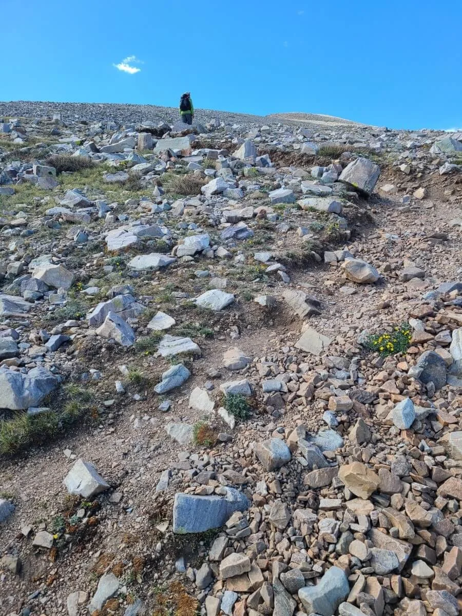
We aren’t going to sugarcoat this one…the hike to Wheeler Peak is a grind. As you’ll see in just a minute when we describe our experience hiking to Wheeler Peak, the trail starts off deceptively easy. However, once you get on the ridge which you’ll follow the rest of the way up to the summit, the going gets tough…and rocky…and steep. And all of this is at high altitude, which will probably slow you down even more. Take it slow, listen to your body, and turn around if you start feeling sick. Be sure to stay really hydrated and eat lots of snacks as you hike.
Once you hit the ridge, the Wheeler Peak hike truly just becomes a slog. It’s not very technical, it just becomes a game of mental fortitude and just putting one foot in front of the other until you reach the summit. But trust us when we say that it’s worth it…the views from the top, and really the whole ridge, are amazing!

The Wheeler Peak hike only becomes steeper and rockier the higher you go!
Hiking Wheeler Peak in Great Basin National Park: Our Experience
The best way to prepare you for a hike to Wheeler Peak in Great Basin is to give you our experience! This will show you what to expect on the trail to see if it’s something you want to tackle.
We got to the Wheeler Peak Summit Trailhead at about 7:30 am or so, and there were only a few other cars in the lot, although quite a few more showed up as we were getting ready. From what we could tell, though, this small lot never filled up that day, and even if it did, you could always park at the larger lot at the end of the road and start your Wheeler Peak hike from there.
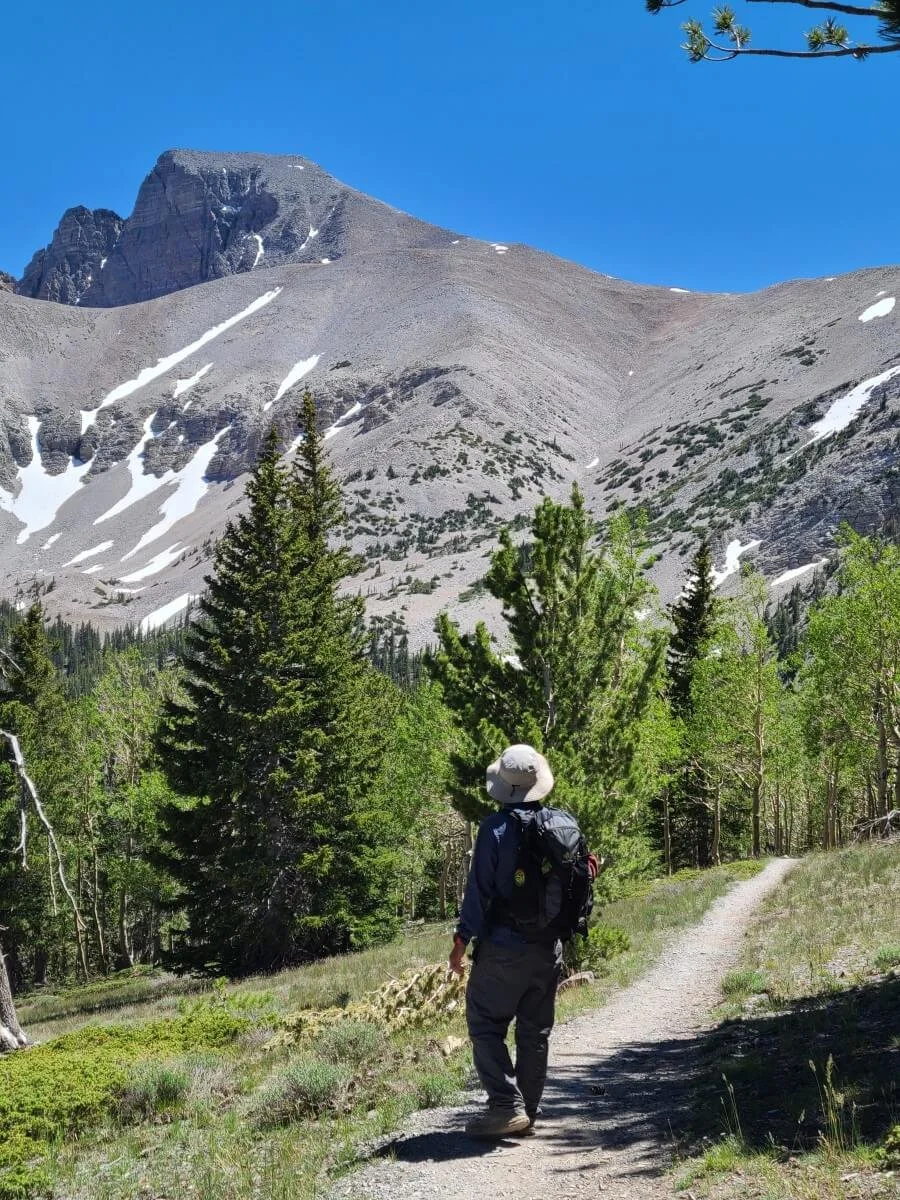
About 20 minutes later, we were on the trail! The first mile of Wheeler Peak Summit Trail is a fast and flat connector trail to meet up with the Alpine Lakes Loop. The majority of this trail is flat with very small and gradual uphill stints. You’ll be mostly walking through a beautiful aspen forest, and from the trail you can see Wheeler Peak and its surrounding jagged mountain tips peaking through the trees.

Walking through wiggly trees at the beginning of the Wheeler Peak Summit Trail
After about a mile of hiking, you’ll merge onto the Alpine Lakes Loop trail just very briefly. After about just two minutes on this trail, you’ll hit another junction and turn right here to continue on the Wheeler Peak Summit Trail instead of the Alpine Lakes Loop.

Once on this portion of the Wheeler Peak hike, you are basically doing one very long switchback to get onto Wheeler Peak’s rocky ridge. Here, the hike is still pretty easy…the incline is very gradual, and it’s a good warm up for your legs for what’s to come. Enjoy this part!
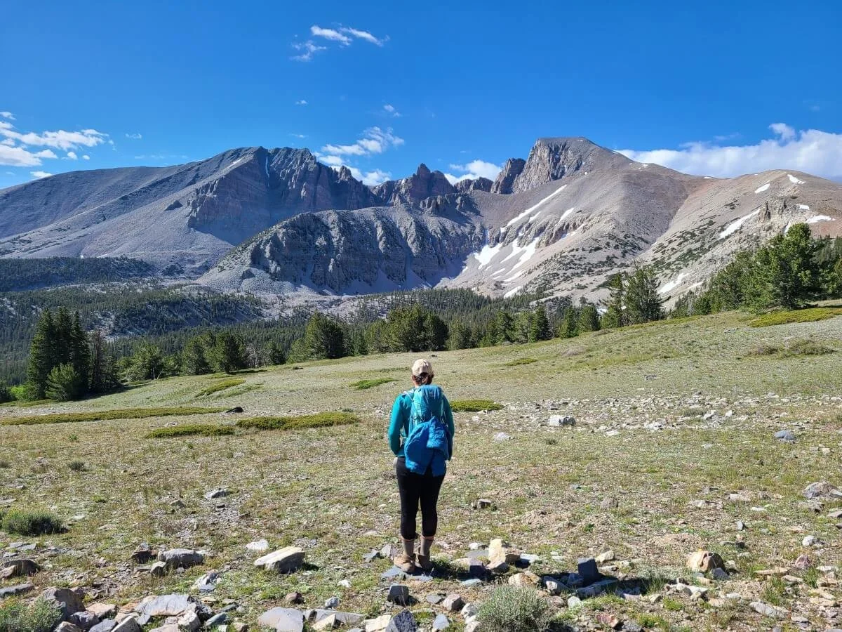
As you leave the tree line, you’ll find yourself in beautiful subalpine meadow…don’t forget to keep turning around because the whole Wheeler Peak cirque comes into view here behind you and it’s epic-looking! But, it’s also quite intimidating, knowing that’s your destination for the day!

Gorgeous views from the Wheeler Peak Summit Trail!
Once you make the one switchback, you’ll turn so that these awesome views are now in front of you.
As you get closer to the Wheeler Peak ridge, the terrain gradually starts turning into more of the rocky alpine landscape that will dominate the rest of the hike. As you traverse the side of the ridge’s slopes, Stella Lake will come into view below you and you’ll walk right over the top of it.

The switchback in the trail up to Wheeler Peak

Hiking up to the Wheeler Peak Ridge, with Stella Lake below
Before you know it, you’ll make it onto the Wheeler Peak Ridge…now the fun (aka hard) stuff begins! Welcome to the rocky steepness of the ridge!
At first you’ll be walking through a sparsely forested portion of the ridge as you follow a well-worn herd path through the rocky terrain. We saw a few deer here, so keep your eyes peeled!

It’s starting to get steep!

Once you leave the trees behind, you’re now on the exposed ridge for the rest of the climb, and the trail quickly becomes quite steep as you navigate small switchbacks through the loose rock and shale. While there are no proper trail markers (aside from a few rock cairns here and there), there is a pretty well-defined trail in the rock that is easy to follow, and there’s only way to go…up!
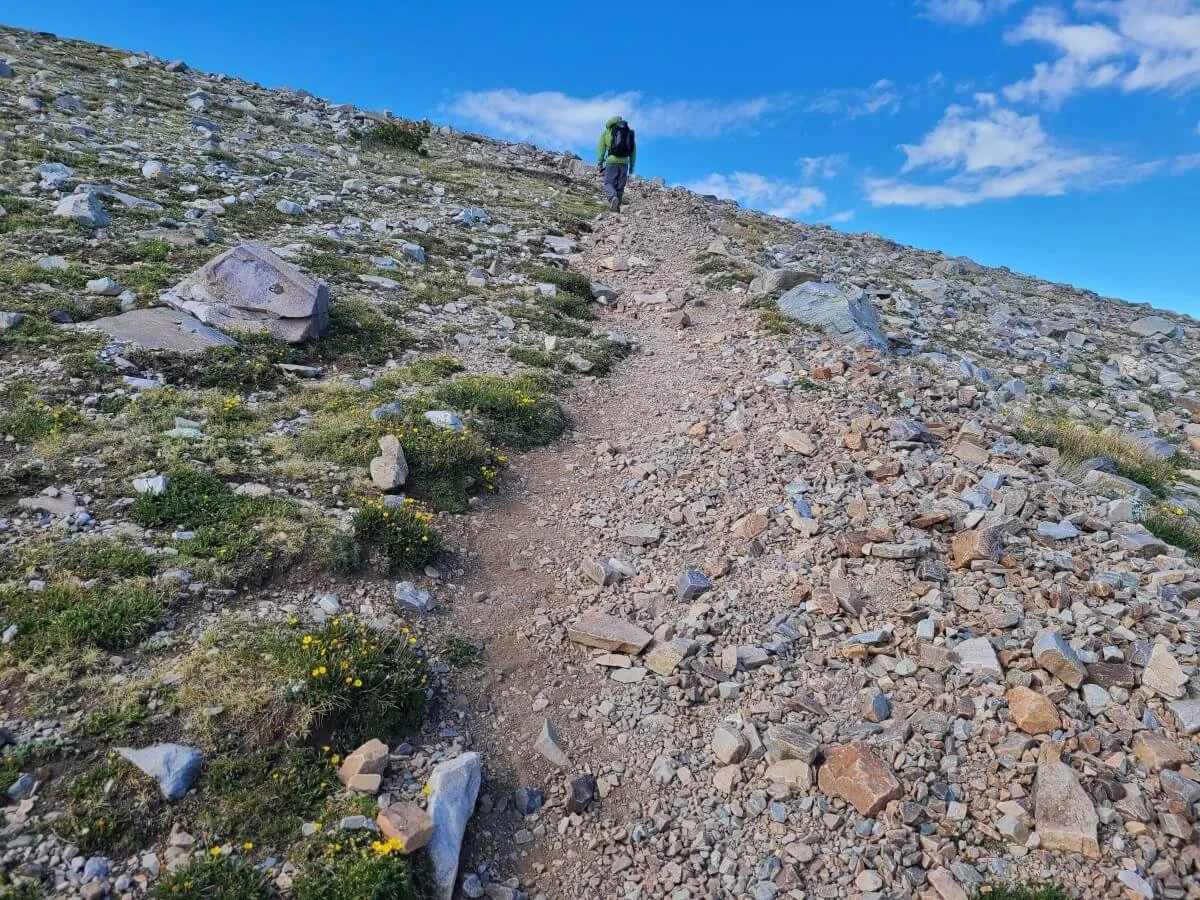
Heading up the steep Wheeler Peak ridge
Once you hit the ridge, it’s honestly just a slog up for the rest of the hike to Wheeler Peak. It’s steep and loose rock the entire way, and it just seems to get steeper the higher you climb. Just keep putting one foot in front of the other and take breaks as needed. The good thing is that from the ridge, the views are already amazing. Wheeler Peak, though still intimidating, lies ahead, and the Snake Range stretches out around you with the flat Great Basin desert in the distance. And the views only get better the higher you climb, which is motivation to keep you going!

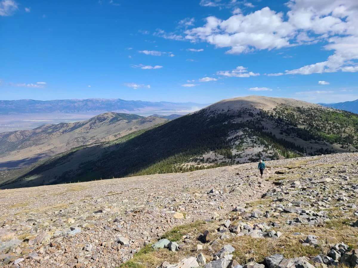
The view behind you on the Wheeler Peak hike- the appropriately named Bald Mountain and the Great Basin Desert beyond

After a while of climbing, you’ll top off on sort of a false summit…these are the worst, we know! But, it means that there’s a nice flat portion of the ridge that provides a nice break from the so far continuous climb up to the summit. Enjoy it while you can! Or, at least try to. It’s often windy along the Wheeler Peak ridge, and this portion of the hike is often where you find the wind. On the day we hiked to Wheeler Peak, the wind here was absolutely insane! It was non-stop gusty and chilly wind that made it hard to walk forward and hard to even breath. Make sure to pack layers for the hike…we had to pull out our hats jackets for this part!


Kevin at the start of the flat part of the Wheeler Peak ridge

This part of the Wheeler Peak hike is a nice relief, but it was super windy, and the intimidating final push to the summit lies ahead!
To add insult to injury, the final push to the summit lies ahead, and it doesn’t look too inviting. Luckily, once we got off this flat portion and started our next climb, we seemed to hike out of the wind zone and it was back to normal.
This last push to the summit, though, is unfortunately the hardest and steepest part of the entire Wheeler Peak hike (gotta save the best for last, right?). I took a lot of microbreaks as I chugged up to the summit, as the altitude was really starting to take its toll on my stamina up here. Along this section, we saw a lot of the morning crowd coming down from the summit, giving us friendly motivation to keep on pushing.


I tried often to capture the steepness of the Wheeler Peak hike (but really it was an excuse to take lots of breaks on the way up!)

Don’t forget to look at the great views behind you! Stella and Teresa Lake appear in the valley below.
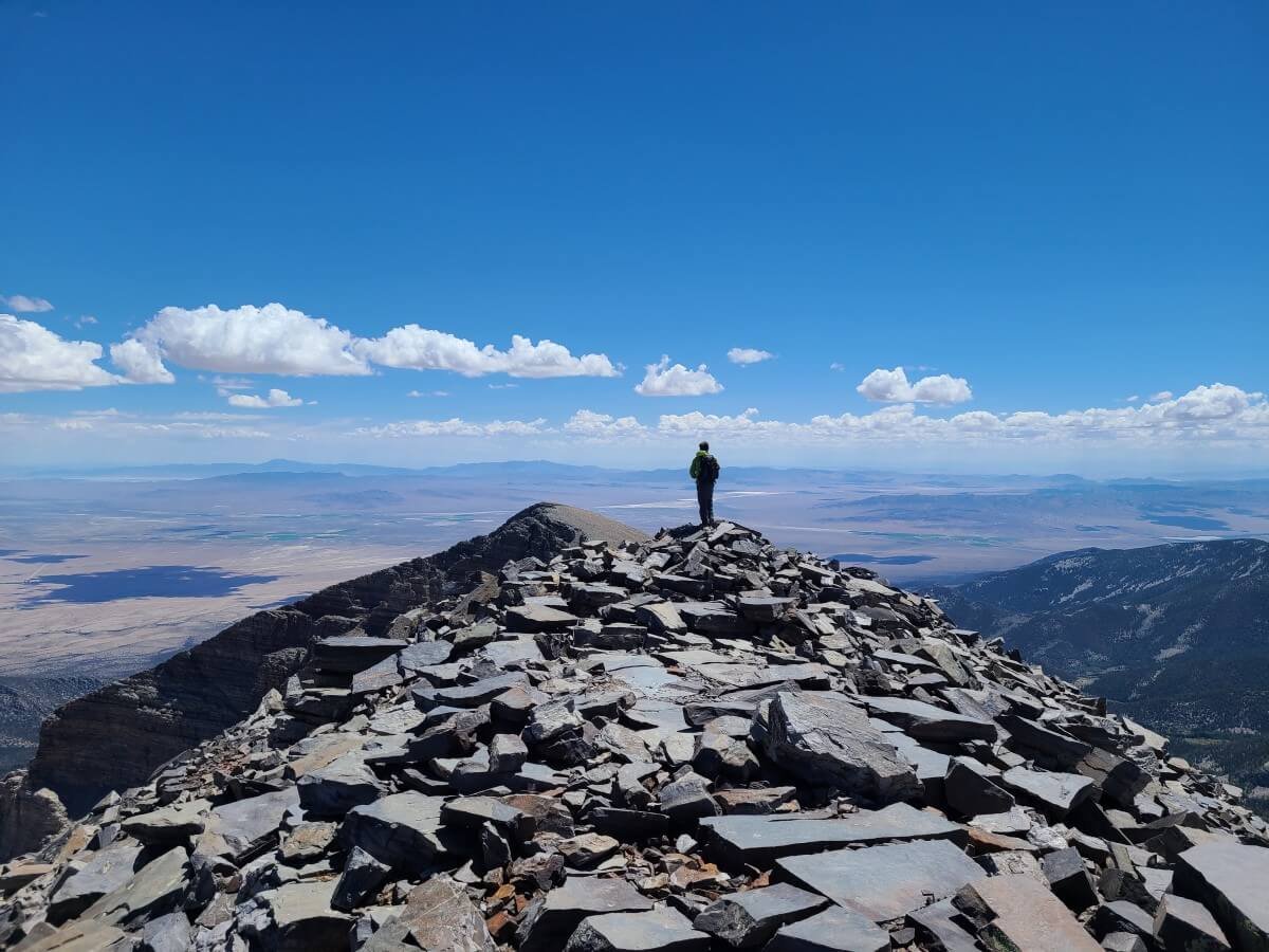
And then, just about three hours after we started almost 3,000 feet below at the trailhead, we made it!
And let me tell you, the 360 degree views from this 13,064 foot summit were definitely worth the climb. We stayed up here for nearly an hour and a half just reaping the rewards from our efforts. And incredibly enough, we were up there on our own the entire time. When we arrived at the summit, there was just one pair of hikers finishing up their pictures and quickly began their hike down, so we enjoyed these amazing views in complete solitude.

Epic views from the Wheeler Peak summit!

Kevin enjoying the well-deserved views from the summit of Wheeler Peak


Kevin standing on the tallest point of the Wheeler Peak summit!
Luckily, it wasn’t too windy at the summit for us, but there are nice rock shelters at the top that you can take cover in while you rest and eat lunch.
After a while, a large group was heading up to the summit, so we decided to start our hike back down. The down climb was much faster than going up, but just be sure to step carefully and watch your footing. The scree and loose rock can be quite slippery and unstable, and you want to be careful to not dislodge any large rocks that could tumble down towards hikers below. Trekking poles might also be good here because the steepness here can be rough on the knees.

Heading back down the steep and rocky Wheeler Peak trail


Once off the ridge, the rest of the hike through the meadows and forest is a breeze, and you can look back from here at the Wheeler Peak summit with a giant sense of accomplishment! Looking back at the mountain, we couldn’t believe we were standing on top of it just an hour or so ago.

The last part of the Wheeler Peak hike is a breeze, and with amazing views!
Looking back up at the Wheeler Peak summit with a big sense of accomplishment!
It took us about two hours to get back to our car from the summit, and we had the rest of the afternoon to go set up camp, relax, and revel in the day’s accomplishment.
Best Time to Hike to Wheeler Peak, Nevada
The best time to hike to Wheeler Peak in Great Basin is generally the end of May to mid-October. This is when the scenic drive that leads up to the trailhead tends to be open and snow-free. However, always check conditions before heading out! In 2023, the road, which usually opens around Memorial Day weekend, is not projected to open until July 1st because of the unusually high snowpack that the park got this winter!
Even in more normal years, snow can still linger a bit later on the trails in the spring, or start earlier in the fall than expected. Even when we were on the Wheeler Peak hike in early July, there was a snow patch or two we had to cross towards the top. It was nothing big, or anything that required extra gear like microspikes, but just something to be aware of.

A small snow patch on the Wheeler Peak hike
Also, any time of year, but especially earlier or later in the hiking season, the ridge and summit can get very cold with even colder wind chills, so come prepared with layers, hats and gloves.
In terms of when to hike Wheeler Peak to avoid crowds, I honestly don’t think that this hike ever really gets crowded, relatively speaking. Great Basin is one of the least visited parks in the country due to its remoteness, and while some sights and hikes are more popular than others, we never experienced any crowds in the true sense of the word (we were there mid-week in early summer, though I imagine summer weekends may experience a bit more crowding). As with many places, getting an earlier start is always a good tip for avoiding the worst of any crowds on the trails. That said, when we were close to the top of the Wheeler Peak summit just before 11 am, there were a surprising number of people that were heading down from the summit that definitely didn’t reflect the small number of cars that were in the Wheeler Peak Summit Trailhead lot. We guess that this was the sunrise crowd that probably started their hike from the nearby Wheeler Peak campground. On the contrary, we started our hike just before 8 am and really didn’t see too many others going in our direction, and had the summit completely to ourselves for a good hour and a half. If you really want to avoid any crowds at the summit, just avoid peak summer weekends and you should be good.
What to Bring on the Wheeler Peak Hike
Aside from the usual hiking essentials, here are some things we would recommend specifically for hiking to Wheeler Peak in Great Basin National Park.
Good hiking shoes- Once on the ridge, the Wheeler Peak hike is all steep loose rock and scree. Having proper hiking shoes is key here.
Hiking poles- Because the Wheeler Peak hike is so steep, the way down can be rough on the knees, so if you are used to having hiking poles, make sure to bring them for this trail!
Lots of water and food/snacks- Bring at least 3 liters of water for yourself for the Wheeler Peak hike. Not only is it a long exposed hike, but it’s at altitude, and staying hydrated and eating snacks to stay energized is an important part of warding off altitude sickness. Fill up with water at the Lehman Caves Visitor Center (campgrounds and picnic areas usually don’t have a water supply…so don’t expect to fill up at the nearby Wheeler Peak Campground!).
Sunscreen and sun protection- Most of the Wheeler Peak hike is on an exposed ridge at altitude, so sun protection is important here.
Layers- Even in summer, bring layers! It can be cold up at altitude, and the wind can get pretty strong along the ridge. Even in July, we broke out our hats and jackets on the Wheeler Peak hike.
Rain gear- Just in case…afternoon storms are common in the summer especially.
Where to Stay Near Wheeler Peak in Great Basin National Park
If you want to stay right near the Wheeler Peak hike, staying at the Wheeler Peak Campground in Great Basin National Park is the place to be. This campground is right at the end of the Wheeler Peak Scenic Drive, and you can walk to the Alpine Lakes Loop trailhead from here to begin the hike (if you want to start at the Wheeler Peak Summit Trailhead like we did, you’ll have to drive just a few minutes down the road). This campground is reservable up to 30 days in advance and can book out fairly quickly, so try to be on recreation.gov on the day the sites open for reservation to get a spot.

Our tent in the Wheeler Peak Campground
Otherwise, there are four other developed campgrounds in Great Basin National Park. Upper Lehman Campground would be the next closest campground to the trailhead (about 9 miles down the scenic drive), followed by Lower Lehman Campground. Upper Lehman is reservable, while Lower Lehman is first come first served.
The two other campgrounds are on Baker Creek Road, which is a graded gravel road near the Lehman Caves Visitor Center. Grey Cliffs campground is reservable, while Baker Creek campground is first come first served, and spots are usually available except maybe on peak summer holiday weekends.
There is no lodging right in Great Basin, but just outside of the park in the small town of Baker there is some very limited options for both lodging and camping. Otherwise, the larger town of Ely has a bunch of options, but is an hour away from the park and the Wheeler Peak trailheads.
Tips for Hiking to Wheeler Peak in Great Basin National Park

Start early. This isn’t necessarily to avoid any crowds, but you just want to give yourself plenty of time to complete this challenging hike. Plus, afternoon storms are common in the summer, so you want to plan to be off the exposed ridge before they develop (planning to be off around 2 pm or so would be a good idea). Remember, you’re at altitude, so add some padding time into what your usual pace is, as the altitude might slow you down a bit.
Acclimate. The trailhead for Wheeler Peak starts at 10,000 feet and only goes up from there! You’ll top out at over 13,000 feet, so you really want to make sure you properly acclimate before hiking to Wheeler Peak. Take some time to do some lower elevation hikes in the days before. Hike around the Lehman Caves Visitor Center area and do a cave tour there. Just up the road on the scenic drive, you can do a short hike on the Osceola Ditch Trail or the Lehman Meadows Trail. A good hike to do the day before your hike to Wheeler Peak would be one of trails at the end of the Wheeler Peak Scenic Drive, such as the Alpine Lakes Loop and the Bristlecone Pine-Glacier Trail. These hikes are way less strenuous but fall between 10,000-11,000 feet in elevation. Finally, spend a night or two camping at one of the developed campgrounds in the park. And be sure to stay hydrated the whole time you’re in the park.
Check weather and conditions. Before heading out to hike Wheeler Peak, check weather forecasts and trail and road conditions for any closures or delayed openings.
Bathroom. There is no bathroom at the Wheeler Peak Summit Trailhead (at least when we were there), but there is one at the Bristlecone Lot, so just plan for that.
Looking for More Things to Do Near Wheeler Peak in Great Basin National Park?
Check out our other Great Basin National Park guides to help you plan your visit!
Other hikes in Great Basin National Park- Looking for less challenging but equally scenic hikes in Great Basin? Check out our guide to our three favorite hikes in Great Basin to learn all about the Alpine Lakes Loop, Bristlecone Trail, and Glacier Trail, and how to combine all three into one epic Great Basin hike.
Great Basin Guide and Itineraries- Check out all the amazing things to do in Great Basin (besides hiking!) and learn how to plan your time with our 1 to 3 day Great Basin National Park itineraries.
Are you planning to hike to Wheeler Peak in Great Basin National Park? Let us know if you have any questions! We loved the Wheeler Peak hike and want you to have a great experience, too!