How to Hike the Greenstone Ridge Trail: The Best Backpacking in Isle Royale National Park
Are you looking for one of the best backpacking routes in Isle Royale National Park? Then look no further than the Greenstone Ridge Trail. This 40+ mile route travels the entire length of Isle Royale and is packed with views, solitude, and wildlife viewing. In this guide, we go over everything you need to know to hike the Greenstone Ridge Trail in Isle Royale, including how long it takes, different route options, how to arrange transportation, and much more!

Isle Royale National Park is the ideal place for a backpacking trip. Its remote location in the middle of Lake Superior combined with its pristine wilderness means crowd-free hiking trails where you can truly experience solitude and nature at its best. And one of the best backpacking routes in Isle Royale National Park is the Greenstone Ridge Trail.
The Greenstone Ridge Trail in Isle Royale is an approximately 40 mile point-to-point backpacking route that runs along the entire length of the island from Rock Harbor on the east side to Windigo on the west side. It’s one of Isle Royale’s best backpacking routes because it has a little bit of everything – shoreline walks along Lake Superior, ridge top views over the island, quiet and serene forest walks, hikes through swamp and marsh habitat for good wildlife viewing opportunities, and campsites at peaceful inland lakes where you can fall asleep to the sounds of loons calling out as the sun sets. Sound too good to be true? It’s not!
The only catch is that the Greenstone Ridge Trail can be a little logistically complicated to plan. Not only is this hike on an island in the middle of the country’s biggest freshwater lake that can only be accessed by ferry or seaplane, but it’s also a point-to-point hike that requires the right mode and timing of transportation at the start and end of the trail. Plus, there are several different route options for the Greenstone Ridge trail that will determine where you camp each night and how many days it will take you.
Sound complicated? Don’t worry…that’s where we come in!
In this guide, we’re going over absolutely everything you need to know to backpack the Greenstone Ridge Trail in Isle Royale National Park! We’ll go over different route options and where to camp on the Greenstone Ridge Trail, how to arrange all your transportation, costs, what to pack, and lots more. If you’re planning on hiking the Greenstone Ridge Trail, this article is a must-read!
In this Greenstone Ridge Trail backpacking guide:
How to arrange transportation for the Greenstone Ridge Trail
How much does it cost to backpack the Greenstone Ridge Trail?
Alternative ways to hike the Greenstone Ridge Trail in Isle Royale
Where is the Greenstone Ridge Trail?

A beautiful lake at a campsite along the Greenstone Ridge Trail in Isle Royale
The Greenstone Ridge Trail is one of the best backpacking routes in Isle Royale National Park. This park is an island wilderness located in Michigan in the middle of Lake Superior and is only accessible by boat and seaplane. Here, you’ll find beautiful rocky shoreline along Lake Superior with those “evergreens-meet-the-sea” views, ridge-top trails with views over Lake Superior and out to Canada, quiet forest walks, peaceful inland lakes, and tons of wildlife like moose, beavers, eagles, loons, otters and more.
Because it’s a bit complicated to get to, and because it’s not associated with the same “wow” factor as other more popular National Parks, Isle Royale remains the least visited National Park in the lower 48, and is somewhat of a hidden gem for backpackers, hikers, and outdoor enthusiasts.
But others’ loss is absolutely our gain…because instead of crowds, what you’ll find on Isle Royale is empty trails, abundant wildlife, and peaceful solitude.
The Greenstone Ridge Trail allows you to experience all the best features of Isle Royale on one backpacking route. It runs the entire length of Isle Royale (from Rock Harbor to Windigo) along its highest ridge in the middle of the island. On your hike across the island, you’ll walk by Lake Superior, hike through marsh, swamp and forest, and get amazing views along an exposed high ridge.
Where does the Greenstone Ridge Trail start and end?
Windigo is a common starting and ending point for the Greenstone Ridge Trail
There are a couple different places to start the Greenstone Ridge Trail on Isle Royale.
On the eastern end of the island, there are two common starting places for the Greenstone Ridge Trail-Hidden Lake and Rock Harbor. On the western side of the island, the start and end of the Greenstone Ridge Trail is in Windigo.
Hidden Lake Trailhead
If you want to hike the entire Greenstone Ridge Trail proper, then you should start at Hidden Lake. From Hidden Lake, you’ll hike up to the popular Lookout Louise viewpoint, which is where the Greenstone Ridge Trail starts. From here, it’s a straight shot all the way to Windigo. The complication with this is that in order to get to the Hidden Lake Trailhead, you’ll have to take a water taxi from Rock Harbor. This water taxi is run by the Rock Harbor Lodge, and can be reserved in advance. It’s a quick ride, but is slightly pricey depending on how many people you have:
One Person: $38.00
Two People: $57.00
Three People: $61.00
Four People: $65.00
Five People: $69.00
Six People: $73.00
Rock Harbor
If you don’t want to deal with the water taxi and just want to start your hike on the Greenstone Ridge Trail from Rock Harbor, then that’s possible, too, and it’s what we did. You can simply start your hike on the Rock Harbor Trail behind the visitor center and head toward Three Mile Campground. Here, you’ll turn up a trail to head up onto the ridge and meet up with the Greenstone Ridge Trail. This will make sense once we talk about route options for the Greenstone Ridge Trail below.
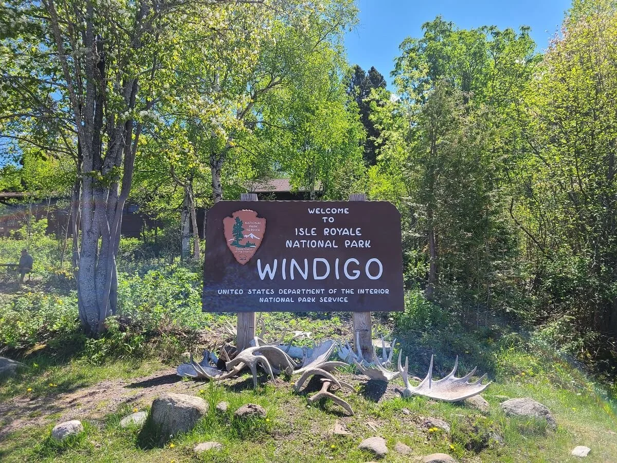
Windigo
Windigo marks the other end of the Greenstone Ridge Trail in Isle Royale. The trail begins just past the Washington Creek Campground and is the only starting point of this trail on this end of the island.
Greenstone Ridge Trail map
Here is a high level map of the Greenstone Ridge Trail to give you a better idea of where the Greenstone Ridge Trail goes along the island. We’ve labelled the common starting points for the Greenstone Ridge Trail on the map.

This map is taken from the National Park Service. We have highlighted the full Greenstone Ridge Trail in green, and marked the three common starting and ending points of the hike.
Which direction should you hike the Greenstone Ridge Trail?
The Greenstone Ridge Trail can be hiked east to west (Rock Harbor to Windigo) or west to east (Windigo to Rock Harbor). So, which direction is best?
Honestly, it doesn’t matter too much, but there are some things you may want to consider when deciding the direction you want to hike the Greenstone Ridge Trail.
Transportation-The direction you hike the Greenstone Ridge Trail may simply be decided on availability of transportation to and from each trailhead on the days you want to hike. Planning out your transportation in advance is an important first step in planning your hike on the Greenstone Ridge Trail, and we’ll go over that in just a second!
Views – The eastern end of the Greenstone Ridge Trail, in our opinion, is the better half – only because it was the side that had all the views from the ridge. Once you get to the western end of the trail, you’re mostly walking through forest and have come off the exposed portions of the ridge. Don’t get me wrong, we still loved this portion, but of course you can never really beat a good view. If you’re the kind of person that likes to save the best for last when hiking, then you might want to hike the Greenstone Ridge Trail from Windigo to Rock Harbor.
Post-hike recovery- Rock Harbor can be considered a bit more “touristy” than Windigo (though neither could be considered touristy or crowded in the traditional sense!). Rock Harbor has more services, including full lodging and a restaurant. Windigo doesn’t have much- just a visitor center and small campstore. It certainly has a more remote, wilderness feel to it. If you’re looking for some real food, a warm shower, and maybe a nice bed to lay on after you’ve been hiking the Greenstone Ridge Trail for four days or more, then you’ll definitely want to hike from Windigo to Rock Harbor! On the other hand, we actually liked ending our hike in Windigo, and experiencing that last bit of pristine and quiet wilderness before leaving the island. It’s totally your preference!
How to Arrange Transportation for the Greenstone Ridge Trail

Fresh off the Isle Royale ferry and ready to start the Greenstone Ridge Trail!
Because it’s a point-to-point hike, and because it sits on a remote island accessible only by plane or boat, organizing transportation logistics can be half the challenge of hiking the Greenstone Ridge Trail! It can seem confusing at first, but we’ll break it all down for you here to hopefully make it seem a little less daunting.
There are four departure points for Isle Royale from the mainland- two in Michigan and two in Minnesota. Each has a different combination of ferry and seaplane options to get to the island, and some may only go to Rock Harbor or Windigo only, and not both. As you’ll be able to tell in just a minute, utilizing the seaplanes is much more convenient and easier than the ferries. It’s a quick ride (minutes instead of hours) and it lets you get dropped off and picked up from the island in different locations instead of having to figure out additional inter-island transport to get back to your starting point. However, this additional convenience comes with a much steeper price tag.
Let’s go over each option of getting to the start of the Greenstone Ridge Trail and back to your car at the end.
Transportation for the Greenstone Ridge Trail: Starting in Rock Harbor
If you want to start the Greenstone Ridge Trail in Rock Harbor, there are a few options to get there. You can depart from one of four places. Here is the sequence of transportation you will need to arrange from each location.
Copper Harbor, MI
Step 1: Take the Isle Royale Queen IV ferry, which takes just under four hours to get to Rock Harbor. This ferry goes only to Rock Harbor and not to Windigo, meaning you have to organize transport back to Rock Harbor at the end of the Greenstone Ridge Trail.
Step 2: Hike the Greenstone Ridge Trail to Windigo.
Step 3: Get back to Rock Harbor. You can do this by either reserving an interisland seaplane between Windigo and Rock Harbor, or you could book a spot on the Voyageur II ferry, which circumnavigates the island and stops at both Windigo and Rock Harbor on its journey.
Step 4: Take the Queen IV ferry from Rock Harbor back to Copper Harbor.
Cost of getting to and from the Greenstone Ridge Trail: $302 (plus $10 per night for parking at the ferry terminal)

Steps for getting from Copper Harbor to the start of the Greenstone Ridge Trail in Rock Harbor
Houghton, MI
You have two options to get to the Greenstone Ridge Trail in Rock Harbor out of Houghton…a ferry or a seaplane.
Steps for taking a ferry:
Step 1: Take the Ranger III ferry, which is run by the National Park Service and leaves out of Houghton, MI, taking 6 hours to get to Rock Harbor. The pro to this option is that you can do all permitting onboard before you get to the island (we talk about permitting for campsites below).
Step 2: Hike the Greenstone Ridge Trail to Windigo.
Step 3: Get back to Rock Harbor. You can do this by either reserving an interisland seaplane between Windigo and Rock Harbor. Or, you could book a spot on the Voyageur II ferry, which circumnavigates the island and stops at both Windigo and Rock Harbor on its journey.
Alternate Step 3: Once a month during the summer, the Ranger III makes one roundtrip between Houghton and Windigo (every other time it runs strictly to Rock Harbor). If you time it up just right, you can take the Ranger III to Rock Harbor and hike to Windigo in time to catch the ferry back to Houghton from here! This is what we did and it worked out wonderfully. We didn’t have to deal with figuring out and paying for interisland transport between Windigo and Rock Harbor, and it is by far the cheapest way to get transportation to and from the Greenstone Ridge Trail (because you only need one round trip ferry ticket and that’s it!).
Step 4: Take the Ranger III from Rock Harbor back to Houghton.
Cost of getting to and from the Greenstone Ridge Trail: $302, or $160 if you’re able to get the ferry back to Houghton directly from Windigo.
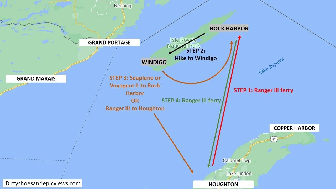
Steps for getting from Houghton to the start of the Greenstone Ridge Trail in Rock Harbor via the Isle Royale ferry
Steps for taking a seaplane:
Step 1: Take the seaplane to Rock Harbor, which will be about 40 minutes.
Step 2: Hike the Greenstone Ridge Trail to Windigo.
Step 3: Take the seaplane back to Houghton from Windigo.
Cost of getting to and from the Greenstone Ridge Trail: $360 (plus $6 per day for parking at the airport lot)

Steps for getting from Houghton to the start of the Greenstone Ridge Trail in Rock Harbor via seaplane
Grand Marais, MN
Your only option for getting to Isle Royale from Grand Marais is by seaplane, which takes about 45 minutes to get to Rock Harbor.
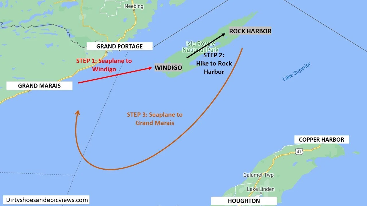
Step 1: Take the seaplane from Grand Marais to Rock Harbor.
Step 2: Hike the Greenstone Ridge Trail to Windigo
Step 3: Take the seaplane back to Grand Marais from Windigo.
Cost of getting to and from the Greenstone Ridge Trail: $390

Steps for getting from Grand Marais to the start of the Greenstone Ridge Trail in Rock Harbor via seaplane
Grand Portage, MN
Two ferries run out of Grand Portage, but only one goes all the way to Rock Harbor from here.
Step 1: Take the Voyageur II ferry. This stops at Windigo first before circumnavigating the North side of the island and stopping at Rock Harbor. This journey will take 7.5 hours to get all the way to Rock Harbor.
Step 2: Hike the Greenstone Ridge Trail to Windigo.
Step 3: You can arrange to take either the Voyageur II ferry or the Sea Hunter III ferry back to Grand Portage.
Cost of getting to and from the Greenstone Ridge Trail: $197 (plus $5 per day for parking at the ferry terminal)
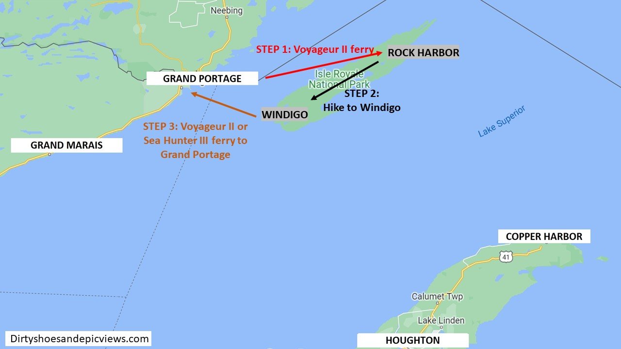
Steps for getting from Grand Portage to the start of the Greenstone Ridge Trail in Rock Harbor
Transportation for the Greenstone Ridge Trail: Starting in Windigo
To get to Windigo to start the Greenstone Ridge Trail, you can depart from one of three places on the mainland. Here is the sequence of transportation you’ll need to arrange for each one:
Grand Portage, MN
There are two ferries that run out of Grand Portage and go to Windigo.
Step 1: Take either the Voyageur II or the Sea Hunter III ferry to Windigo. The journey will be about 1.5-2 hours.
Step 2: Hike the Greenstone Ridge Trail to Rock Harbor.
Step 3: Get back to Windigo. You can take an interisland seaplane that runs between Rock Harbor and Windigo. In Windigo, take either the Voyageur II or the Sea Hunter III back to Grand Portage. Alternatively, from Rock Harbor, you can jump on the Voyageur II as it makes its way around the island. It will make a quick stop at Windigo before bringing you back to Grand Portage.
Cost of getting to and from the Greenstone Ridge Trail:
For the option of using the Voyageur II from Rock Harbor back to Grand Portage - $197
For the option of returning to Windigo via seaplane and then to Grand Portage by ferry - $316 (As you can see, this option is much more expensive. We would only recommend it if you wanted to spend more time in Windigo before heading back to Grand Portage. Otherwise, just take the Voyageur II ferry directly from Rock Harbor.)
There is an additional $5 per day fee for parking at the ferry terminal.
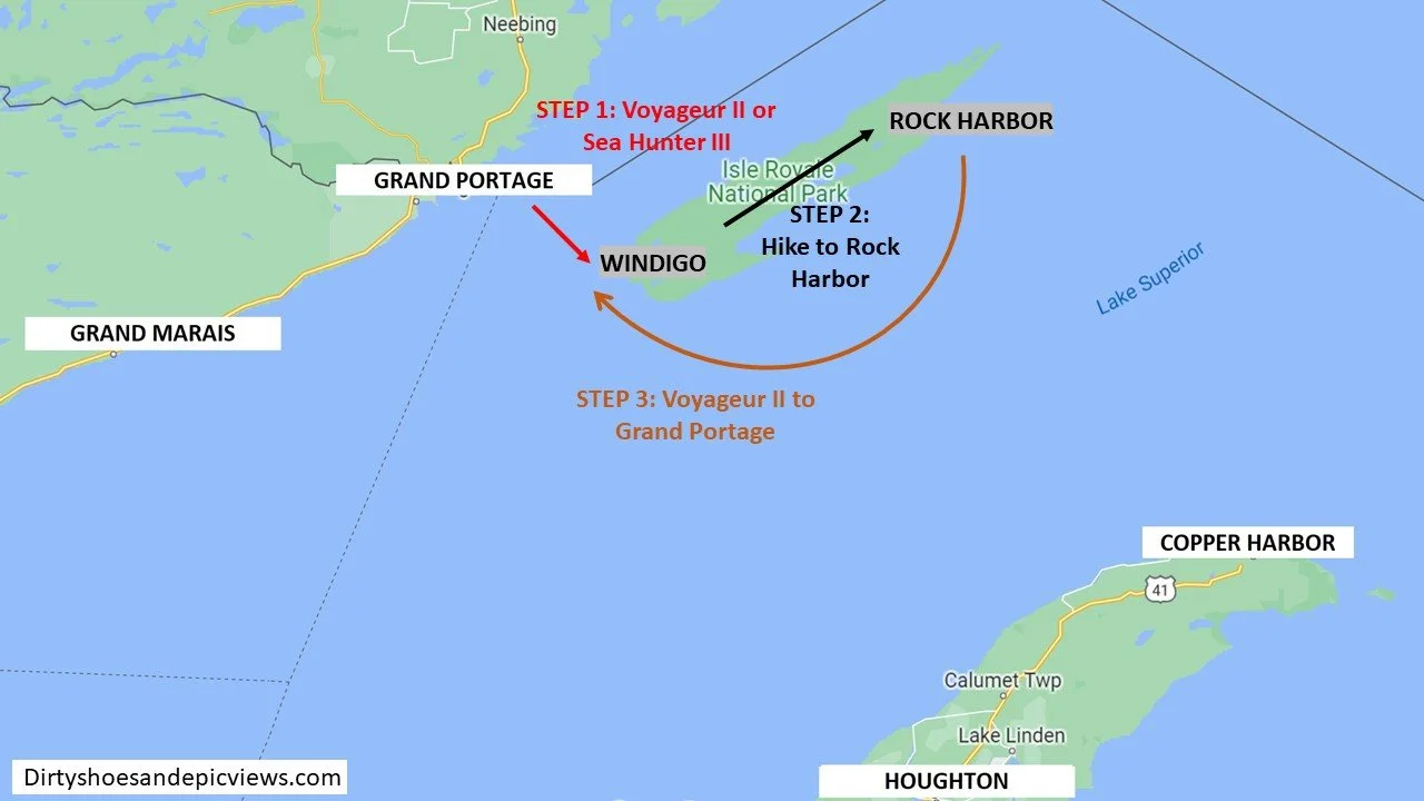
Steps for getting from Grand Portage to the start of the Greenstone Ridge Trail in Windigo
Grand Marais
Your only option from Grand Marais is a seaplane.
Step 1: Take a seaplane to Windigo. The journey is a brief 25 minute flight.
Step 2: Hike the Greenstone Ridge Trail to Rock Harbor.
Step 3: Take the seaplane from Rock Harbor back to Grand Marais.
Cost of getting to and from the Greenstone Ridge Trail: $390
Steps for getting from Grand Marais to the start of the Greenstone Ridge Trail in Windigo
Houghton, MI
The main option from Houghton to Windigo is by seaplane.
Step 1: Take a seaplane to Windigo, a 40 minute flight.
Step 2: Hike the Greenstone Ridge Trail to Rock Harbor.
Step 3: Take the seaplane from Rock Harbor back to Houghton.
However, as we mentioned above, the Ranger III ferry makes one trip to Windigo every month. You can time your trip so that you take the ferry to Windigo, hike the Greenstone Ridge Trail to Rock Harbor, and then catch the next Ranger III ferry back to Houghton from there:
Step 1: Take the Ranger III ferry to Windigo (6 hours)
Step 2: Hike the Greenstone Ridge Trail to Rock Harbor
Step 3: Take Ranger III ferry from Rock Harbor to Houghton
Cost of getting to and from the Greenstone Ridge Trail: $360 (plus $6 per day for parking at the airport lot) for the seaplane. $160 for the Ranger III ferry.

Steps for getting from Houghton to the start of the Greenstone Ridge Trail in Windigo
Tips for arranging transportation to the Greenstone Ridge Trail
Plan ahead! Make sure you reserve all your transportation for the Greenstone Ridge Trail well ahead of time to make sure you can get spots on the ferries or seaplanes on the exact days you’ll need them.
Timing. Each ferry and seaplane has a different schedule to work with. Arranging transportation with seaplanes only is a bit easier because they run daily with multiple flights going back and forth, so you can be quite flexible and really spend as many days as you want on the Greenstone Ridge Trail. Ferries are a bit more complicated to arrange, especially if you need to take more than one. Each ferry operates only on specific days of the week (most are not daily), so you really have to carefully look at each schedule, and really, these schedules will be what dictates how many days you have to hike the Greenstone Ridge Trail.
For example, we used the Ranger III to get to Rock Harbor. We visited at the time of the month when the Ranger would be making its round trip to Windigo five days later, so that was our time limit for hiking the Greenstone Ridge Trail and we couldn’t take any longer than that.
Plan for extra days before and after the hike. It may be the case that you don’t want to get started on the trail on the day you arrive. Or, you’ll probably finish the trail too late in the day to catch any transportation back to the mainland. Plan to spend an extra night either before, or more likely, after, hiking the Greenstone Ridge Trail in Windigo or Rock Harbor to account for this (again, checking schedules of the ferries and planes to plan for your timing is key!). Both Windigo and Rock Harbor have campgrounds you can stay in, or, in Rock Harbor, you can treat yourself to a room in the Rock Harbor Lodge!
More information on the ferries and planes. For all the information you need in one place on the schedules, timing, and costs of each Isle Royale ferry and seaplane, make sure to read our Isle Royale Guide! This will absolutely help you plan out and properly time your Greenstone Ridge Trail hike!
How Long is the Greenstone Ridge Trail?
The Greenstone Ridge Trail in Isle Royale is 40 miles long at a minimum. The total mileage of the Greenstone Ridge Trail, though, varies slightly depending on the route you take and the campgrounds you decide to camp at each night.
Distance of the Greenstone Ridge Trail from different starting points:
Hidden Lake Trailhead to Windigo: 41.2 miles (including .2 miles round trip to Lookout Louise)
Rock Harbor to Windigo: 40.2 miles
All campsites along the Greenstone Ridge Trail are actually off the ridge and not directly on the Greenstone Ridge Trail itself. Each campsite you stay at will add, at minimum, another half mile (but usually more) of roundtrip hiking to the distances above. And because they are all off the ridge, getting to these campgrounds will also add to your total elevation gain for the hike as well.
Here are our stats hiking the Greenstone Ridge Trail from Rock Harbor to Windigo, stopping at three campsites along the way:
Distance: 42.3 miles
Elevation gain: 5387 feet
Trail profile:
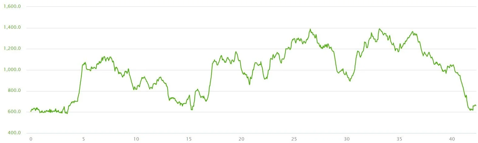
Our cumulative elevation gain on the Greenstone Ridge Trail in Isle Royale
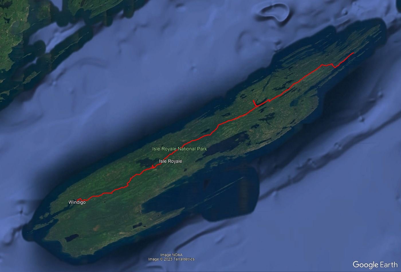
Our GPS track of the Greenstone Ridge Trail in Isle Royale
How many days does it take to hike the Greenstone Ridge Trail?
The number of days to hike the Greenstone Ridge Trail totally depends on how you break up the hike and how many nights you want to camp on the trail. There are plenty of camping options along the route so that you can break up each day into shorter hikes, or, if you’re a strong backpacker, you can go longer distances each day and spend less time on the trail overall.
We’d say the minimum time you need to do the Greenstone Ridge Trail is 4 days and 3 nights. This is what we did, but some of our days were very long, and we kind of wished we had broken it up a little more.
At most, you’ll need 6 nights and 7 days to backpack the Greenstone Ridge Trail if you take advantage of most campgrounds along the way and break up your hike into short spurts. Spending this long on the trail is actually the only way you can avoid having any double digit mileage days on the Greenstone Ridge Trail. Any shorter and you’ll have at least one double digit mileage day.
We’ll talk more about how you can break up your hike, and the different campsites along the Greenstone Ridge Trail, below.
How Hard is the Greenstone Ridge Trail?
There are some tricky trail elements along the Greenstone Ridge Trail
The Greenstone Ridge Trail itself is not too difficult. There’s really nothing technical about it, and it doesn’t ever get very steep, at least not for any prolonged period of time. Though once on the ridge, particularly on the eastern end, you will have lots of ups and downs which can get tiring if you are in the middle of a long day on the trail, but they seem to come in short spurts. However, they do add up. On one long day up on the Greenstone Ridge, we hit over 2,000 feet of cumulative elevation gain!
Most of the terrain on the Greenstone Ridge Trail is soft cushy ground as you walk through the forest, but be aware of your footing as the trail can be very rooty (I may have tripped on a hidden root on a downhill…and trust me, doing that while wearing a heavy pack pushing you forward is not fun…). However, there are definitely parts of the trail that are also rockier and a bit more challenging. The Rock Harbor Trail between Rock Harbor and Three Mile Campground is particularly rocky and filled with boulders, and this kind of terrain can be tiring to navigate with a large pack on. On the exposed parts of the Greenstone Ridge on the eastern end, there is also a lot of granite to navigate which can be hard on the feet after a while.
A rockier portion of the Greenstone Ridge Trail along Lake Superior
We would also say you should have a pretty decent level of route finding skills on the Greenstone Ridge Trail. The trail isn’t super well marked (aside from at most trail junctions), as there are no tree or rock blazes or even rock cairns. On the exposed granite at the top of the ridge, it’s especially important to really watch where you’re going and try to follow the barely visible worn path on the rock. I told Kevin that without his super good route finding skills, I probably would have gotten lost on my own! (Update! Since we have hiked the Greenstone Ridge Trail, there was a forest fire near Mount Franklin which closed the trail for a bit. Since it has reopened, the park service has added cairns to help hikers stay on the correct path in this area!)
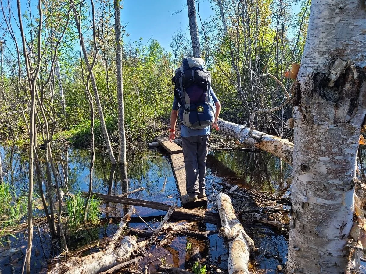
On the parts of the hike that are forested, the trail is much more clear and easy to navigate, with some exceptions. There was one point along the trail where there seemed to be a three or four way intersection that was not marked on the map, and there weren’t any navigational markers to show us where to go. After trial and error, we realized at least one of the paths was a portaging trail to an inland lake. Having a map of the park here really helped us figure out which way we needed to be going! At another point along the trail, we encountered an area where a beaver dam had been built directly across the trail, creating massive flooding of the trail with no reroute. It required us to bushwhack a substantial amount off the trail and eventually find our way back. The park may have since officially rerouted this part of the trail around the dam, but I have a feeling this may happen often and needs to be expected, as a lot of the trail goes by marshes and ponds…prime beaver territory!
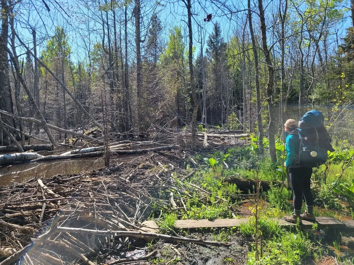
A beaver dam completely cut off this part of the Greenstone Ridge Trail!
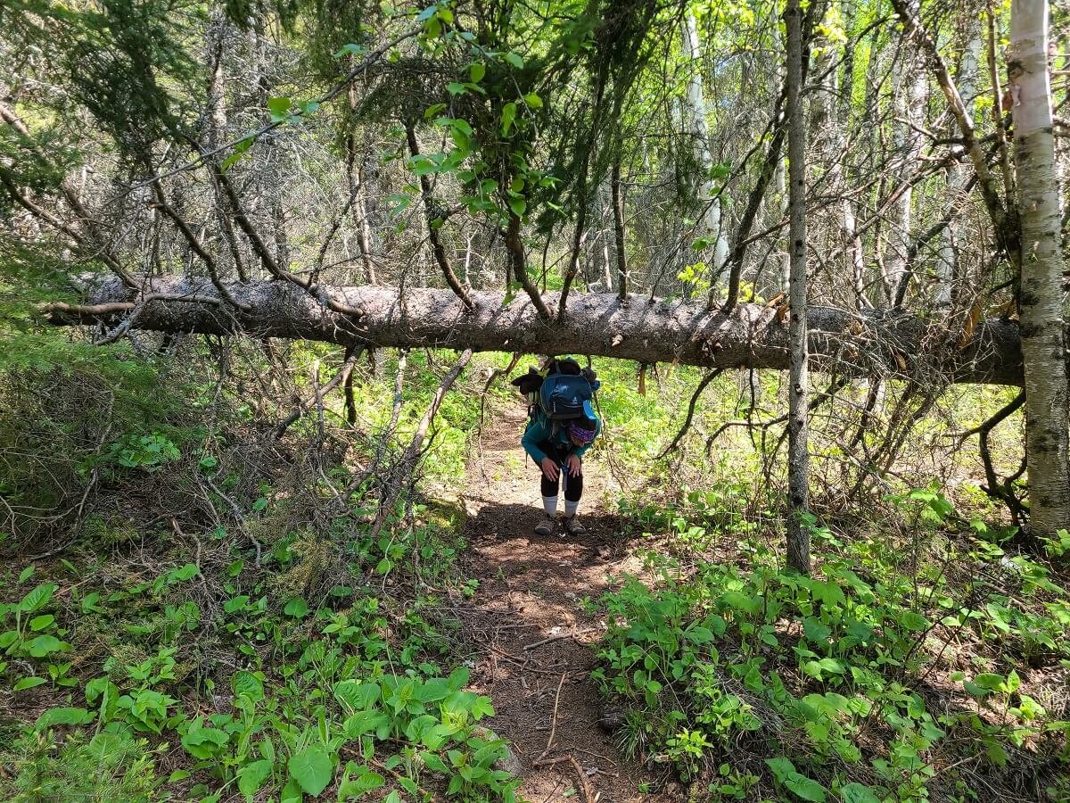
If you hike the Greenstone Ridge Trail in the spring, you can also expect a lot of blowdown along the trail. In May and June, it’s early enough in the season where trail crews haven’t yet cleared trails of the previous winter’s wrath, and some portions of the trail got very exhausting as we had to constantly navigate around and through downed branches and tree trunks with heavy packs.

There was a lot of navigating around and under fallen trees while hiking the Greenstone Ridge Trail!
Finally, the difficulty of the Greenstone Ridge Trail really just depends on how you decide to break it up. If you decide to make it a faster trip and have really long days back-to-back, the ups and downs and rocky paths might seem harder and more exhausting each day. We did the route rather quickly, giving ourselves several double digit mileage days in a row, and we wished we would have broken it up a bit more because those days did feel quite long on the trail.
Where to Camp on the Greenstone Ridge Trail
We’ve told you that there are plenty of places to camp along the Greenstone Ridge Trail…so, where are they?
Here is a handy chart listing all of the campgrounds in Isle Royale and their features, with campsites on the Greenstone Ridge Trail that you are most likely to use highlighted.

This list of Isle Royale campgrounds is taken from the National Park Service. We have highlighted the campgrounds you are most likely to use while backpacking the Greenstone Ridge Trail.
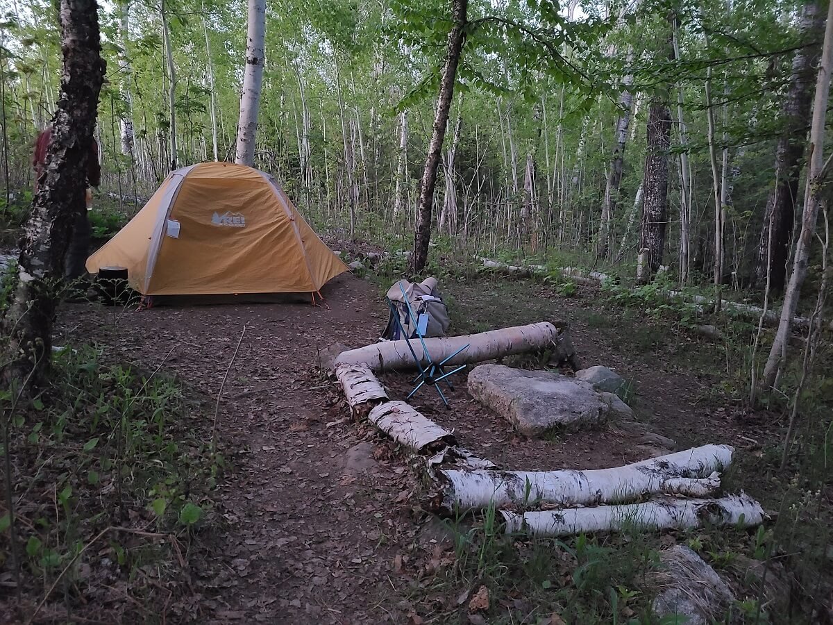
Each campsite on the Greenstone Ridge Trail has a small number of tent sites, an outhouse, and is always next to some sort of water source that you can filter from. Campsites that are along Lake Superior (particularly the ones in Rock Harbor, Three Mile, and Washington Creek) also have sites with shelters (basically enclosed lean-tos) that you can use instead of pitching your tent!
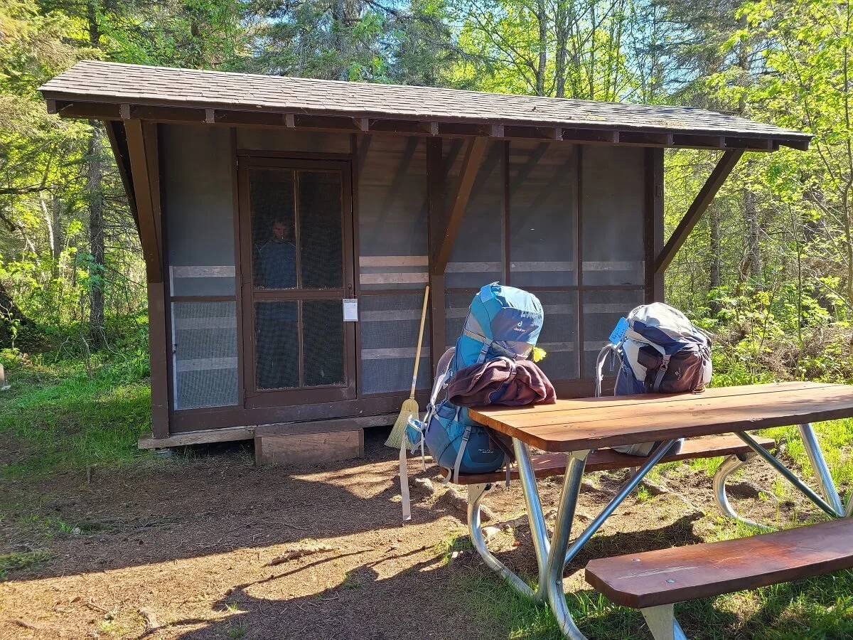
A shelter at the Washington Creek Campground in Windigo at the starting/ending point of the Greenstone Ridge Trail
Do you need a permit to camp on the Greenstone Ridge Trail?
Yes, you do need permits to camp on Isle Royale, including along the Greenstone Ridge Trail, but the good news is that, for groups of 6 or less, Isle Royale camping permits are free! (For groups of 7 or more, they cost $25.)
An amazing thing, too, is that there are no advanced reservations or lotteries to get an Isle Royale camping permit. They are all first come first serve when you get to the island. After deboarding your ferry or seaplane in Rock Harbor, the rangers will greet you and give you an orientation to the island and the rules and regulations of camping. You’ll then fill out a form outlining your backpacking route and itinerary, detailing which campsites you plan to stay at each night of your trip. The rangers do let you know that you are allowed to be flexible with your itinerary, so if you end up getting tired faster than anticipated and need to stay at a closer campground than what you originally planned, then that’s fine. They just really want to know that you do have a general idea and plan for what you want to do and to register that plan with the rangers. Once the rangers have gone over everything with you, they’ll issue you your camping permit, which you then keep on your backpack during the day and on your tent or shelter at night so rangers can see it if they pass by. Easy peasy! If you land in Windigo, it’s usually a self-permitting station at the visitor center that you’ll use to fill out your itinerary and grab your permit.
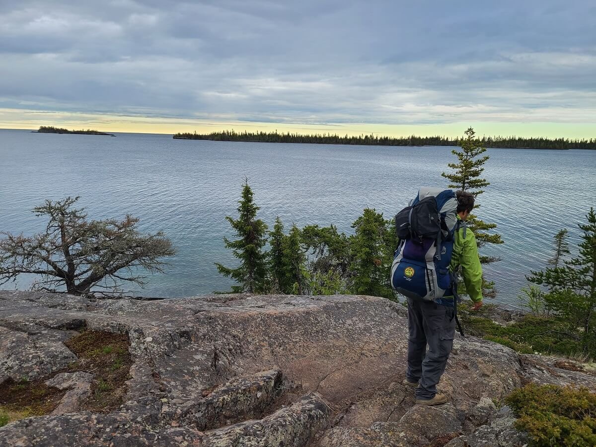
How crowded are the Isle Royale campsites and what if I can't find a campsite?
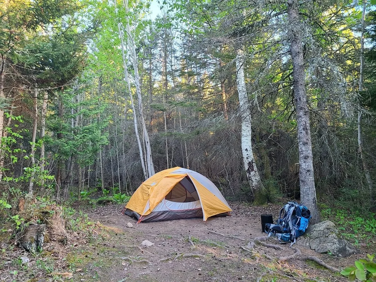
A quiet campsite along the Greenstone Ridge Trail
The thing we loved most about backpacking the Greenstone Ridge Trail in Isle Royale was the complete solitude we found. It was unlike anywhere we had ever been before. The trails seemed nearly empty, and the campsites, though there were people in them, were blissfully quiet and peaceful, like everyone was there for the same common goal of being in nature and just really enjoying its sights and sounds.
With that said, during peak season in July and August, campsites can get crowded, so much so that they have specific guidelines of what to do when campsites do become full, and a ranger will likely go over this with you when you apply for your permit on the island. Basically, if all sites are full, try to double up in tent sites, or fill in the group site areas. If there are shelters, ask to pitch a tent outside the shelter in their site. If all else fails, the park does allow for cross country camping in certain designated zones on the island, which is basically backcountry camping outside of a designated camping site. This should definitely only be used as a last resort, as it can be pretty hard to find a sufficient spot to camp that follows regulations because of how dense the vegetation is on the island. In any case, the rangers actually gave all backpackers at the time one of these cross country permits on a just-in-case basis. Luckily, we never had to use it, and we actually never experienced a crowded campground.
We backpacked the Greenstone Ridge Trail in early June, which is pretty early in the season. None of the campgrounds ever filled up to the point where people were doubling up in sites, which was amazing. It made for very quiet and peaceful nights. We have heard, though, that even in peak season with bustling campgrounds, the mood is still very much peaceful and quiet, and the trails themselves still feel empty, so don’t despair if the busier months are the only time you can hike the Greenstone Ridge Trail!
How Much Does it Cost to Backpack the Greenstone Ridge Trail?

A view over the Greenstone Ridge Trail from the Ojibway Fire Tower
While there are no permits or fees to hike the Greenstone Ridge itself, the experience is still quite expensive as far as National Parks and backpacking in general go.
While camping permits are free, there is a fee to enter Isle Royale National Park. This fee operates a bit differently than most other National Parks because it is a daily fee. You’ll have to pay $7 per person per day spent on the island (including days you arrive and depart). This can add up quickly, especially if you plan to spend a longer time hiking the Greenstone Ridge Trail. If you plan to be there a while, or go back multiple times in a year, the $60 season pass might be more cost efficient.
Another option is to purchase the National Parks Annual Pass for just $80. This gets you into any National Park site for the entire year! And for Isle Royale, it covers park fees for up to four people, so it really pays off at this park.
In order to hike the Greenstone Ridge Trail, you’ll have to pay for transportation to and from the island, and perhaps transportation between trailheads, as we talked about above. This will run you anywhere from $160 to $390 depending on which options you choose.
You’ll also have to pay any daily parking fees at the ferry or airport terminals, which can add up (they are between $5 to $10 a day, except for the Ranger III and the Grand Marais airport, which have free parking).
If you want to start at Hidden Lake, you’ll also have to pay the water taxi fee.
As you can see, hiking the Greenstone Ridge Trail can actually cost hundreds of dollars, which might be why it is not so well-travelled! We hiked the Greenstone Ridge Trail for just about as cheaply as one can do it. We took the Ranger III ferry at a time when it made trips to both Rock Harbor and Windigo, and we had the Annual Parks Pass, so we paid just $160 per person to hike the Greenstone Ridge Trail (just the cost of the roundtrip ferry ride).
Greenstone Ridge Trail Itineraries
With plenty of options for campsites, there are a few different Greenstone Ridge Trail route options and ways to break up your days to spend more or less nights on the trail.
This is a very handy chart from the National Park Service, showing trail distances between every campsite on Isle Royale. This is an important tool to plan your Greenstone Ridge Trail itinerary because it helps you determine how many miles you’d have to hike each day based on what campgrounds you want to stay at each night.

This amazing chart from the National Park Service is super helpful in planning out a Greenstone Ridge Trail itinerary! It can help you decide which campsites to aim for based on the number of miles you want to hike each day on the trail.
Based on this chart, we’ve created some possible Greenstone Ridge Trail itineraries from 3 to 6 nights that we would recommend. Each goes from Rock Harbor to Windigo, but of course, they can be easily reversed. These are just some of the possible itineraries that can be created, and there are several other ways you can divide up the distances, but we wanted to give you an idea of some of the breakdowns and options to help you visualize and plan for your own hike on the Greenstone Ridge Trail.

Here, we show 7 different possible Greenstone Ridge Trail itineraries centered around the most accessible campsites along the hike. The numbers underneath each line indicate the number of miles between campsites. Important note: The distance between Three Mile and Daisy Farm campsites is based on hiking via the Greenstone Ridge Trail by Mount Franklin and Ojibway Tower (so you don’t miss the best parts of the ridge!).
We suggest you use this chart and the mileage chart above as a starting point to help you figure out the best Greenstone Ridge itinerary for you based on how many days you want to be on the trail, how many miles you can handle each day, and your timeframe based on the schedules of the transportation you booked to and from the island.
Our Experience Hiking the Greenstone Ridge Trail in Isle Royale
Now that we’ve gone over all the complicated logistics of planning a hike on the Greenstone Ridge Trail, we want to share with you our experience hiking the Greenstone Ridge Trail to give you an idea of what to expect, which will also help you decide how much you can hike each day and how you should break it up.
We had a pretty aggressive itinerary, completing the Greenstone Ridge Trail in just 4 days and 3 nights, hiking from Rock Harbor to Windigo, and camping at Three Mile, Chickenbone West, and Desor South. This is how we will describe the hike below, but regardless of how you break up your hike, this will give you a good idea of what most of the Greenstone Ridge Trail is like!
Rock Harbor to Three Mile Campground
On our first day of hiking the Greenstone Ridge Trail, we went from Rock Harbor to Three Mile Campground, which is a short hike of just under three miles. We chose to do it this way because we got to Isle Royale on the Ranger III later in the day (around 3 pm). We also decided to hike the Scoville Loop Trail beforehand because we knew we wouldn’t be coming back to Rock Harbor. So, by the time we started hiking the Greenstone Ridge Trail, it was just after 6:30 pm, and a short hike was all that was doable.
The great thing about being on the trail so late was that we saw no one! Though to be honest, this was the theme for our entire time hiking the Greenstone Ridge Trail no matter what time it was.
The start of the Greenstone Ridge Trail behind the Rock Harbor visitor center
The trail to Three Mile (called the Rock Harbor Trail) was a mostly flat path of dirt and rock and followed the shoreline of Lake Superior. There were some minor ups and downs but nothing significant. Along the way, there are some great views of the moody Lake Superior shoreline. Enjoy these, because once you pass Three Mile and climb up to the ridge, you won’t hike alongside the lake again until you reach Windigo!

The path along the lake shoreline on the Greenstone Ridge Trail between Rock Harbor and Three Mile

Loving the moody coastal views along this part of the Greenstone Ridge Trail hike
About 1.8 miles down the trail to Three Mile, you’ll reach an intersection that juts inland and goes to a famous feature on the island- Suzy’s Cave. This is an old sea arch that was formed when lake levels were much higher. I took a break at this intersection while Kevin ran up the trail to check it out. While you’re out here, it’s worth the quick detour!

The trail marker for the junction to Suzy’s Cave

Kevin heading up the short steep path to Suzy’s Cave

Suzy’s Cave
After this, the Rock Harbor Trail got a bit rockier as it hugged the Lake Superior shoreline. Some sections were filled with big boulders that got pretty tiring to navigate around with a fully loaded backpack. This section right here is actually probably the most technically challenging section of the entire Greenstone Ridge Trail! So, it’s good that we were doing it on a fresh set of legs.

The granite pathway along Lake Superior on the way to Three Mile Campground


Even though this leg of the Greenstone Ridge Trail was our shortest, it still had some of the most challenging elements!
We got to Three Mile Campground after an hour and a half of hiking, at 8 pm. This campground is right on the shoreline of Lake Superior and has 8 shelters and 4 tent sites. We were kind of nervous about being able to find a campsite here. The ranger’s orientation on the Ranger III ferry made it sound like campsites might be crowded, and we just expected to have to at least double up with someone after arriving this late at night. But, to our surprise, the campsite was not full at all. All of the shelters were taken, but 3 out of the four tent sites were wide open! We found absolutely the most perfect one to pitch our tent in. The site was secluded, totally private, and right on the water. It even had a little rock outcrop that we could sit on to eat, relax, and enjoy the views.
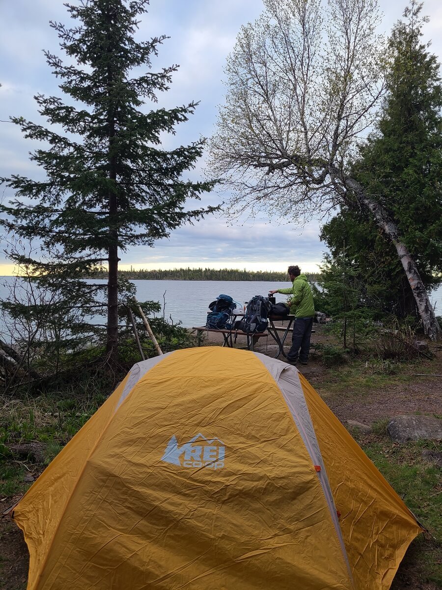
Our lake-side campsite on the Greenstone Ridge Trail!

We got to watch the sunset light up the distant islands from our campsite!
The night at Three Mile Campground was surprisingly quiet and peaceful. We fell asleep to the sounds of water lapping up onto shore. It was our first night experiencing the Isle Royale wilderness, and we were quickly falling in love.
As a side note, the squirrels here were pretty ruthless with trying to steal our food! Make sure you don’t leave any out and keep it stored properly.
Three Mile Campground to Chickenbone West
Today was a big hiking day on the Greenstone Ridge Trail to make up for the short day yesterday. We would be hiking about 12.5 miles from Three Mile Campground to Chickenbone West Campground, which sits on a lake in the island’s interior.
We had a lazy morning, just trying to soak up our time in our peaceful campsite at Three Mile, and didn’t get started on the trail until almost 11 am! Normally, this would be a very late start for a double digit backpacking day, but the long days here in the summer mean the sun doesn’t set until about 10 pm, so there was plenty of daylight ahead.

A peaceful morning at Three Mile Campground before continuing our hike on the Greenstone Ridge Trail!
This part of the trail ended up being our favorite day on the Greenstone Ridge Trail! It was packed with views of the island and Lake Superior.
After packing up camp, we headed for the junction just beyond camp. We took a right turn to get off the Rock Harbor Trail and to start heading up to the ridge toward Mount Franklin. From this junction, the trail started gradually climbing up a mixed path of dirt and rock. It flattens out for a bit as it meanders through forest, marsh, and swamp. We saw lots of giant hares along this part of the trail!

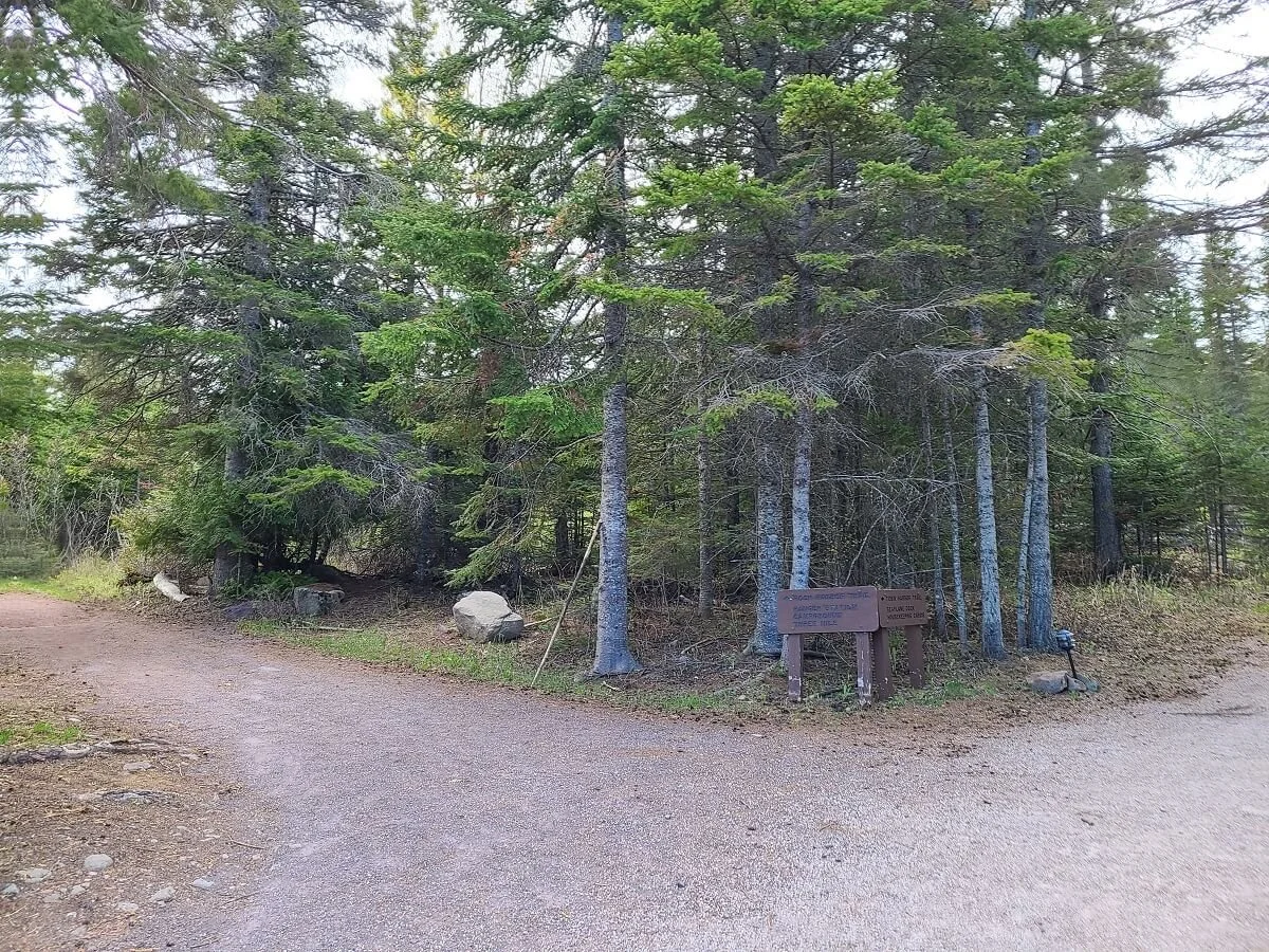
Don’t miss this junction to Mount Franklin found just after the Three Mile Campground


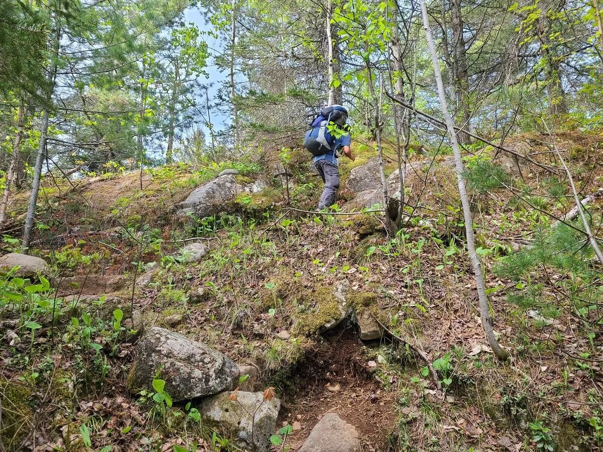
As you get higher, you’ll start hiking up some exposed granite rock, but it’s not until the last half mile to the ridge that the trail really makes its substantial climb up to the Greenstone Ridge. At the end of the climb, you’ll reach a junction that indicates you’ve made it to the actual Greenstone Ridge Trail! From here, it’s a quick easy walk to Mount Franklin.

Some of the more exposed granite trail heading up to Mount Franklin

You’ll walk by a few inland lakes on this peaceful forest walk up to Mount Franklin!


When you’ve hit this trail junction, you know you’ve reached the Greenstone Ridge and you’re almost to Mount Franklin!
Mount Franklin is a gorgeous viewpoint (our favorite!) along the Greenstone Ridge Trail. From here, you can look out over the North side of the island, Lake Superior, and out to Canada on a clear day. It’s a quintessential Isle Royale view, and we got to enjoy it to ourselves for a bit while we took in the scenery.

Mount Franklin has some of our favorite views on the Greenstone Ridge Trail!
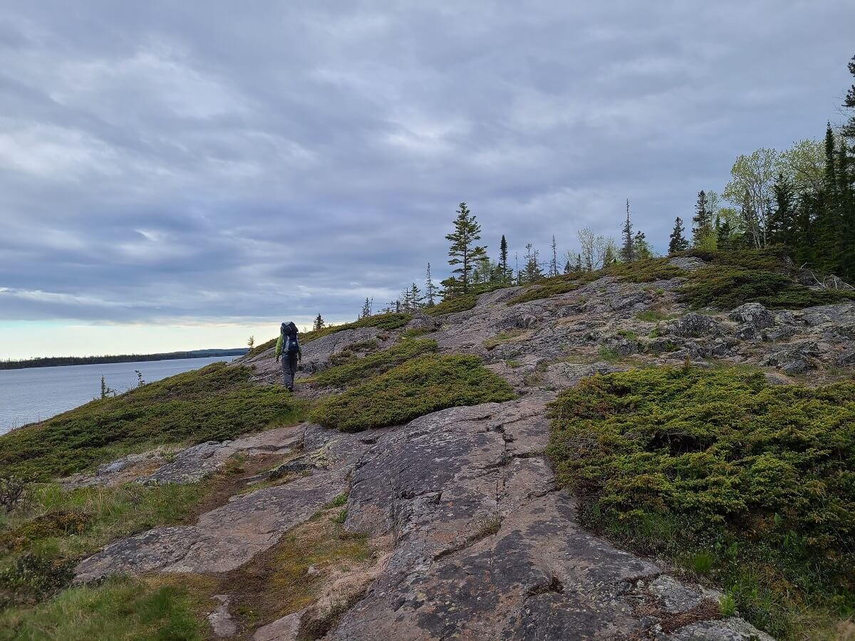
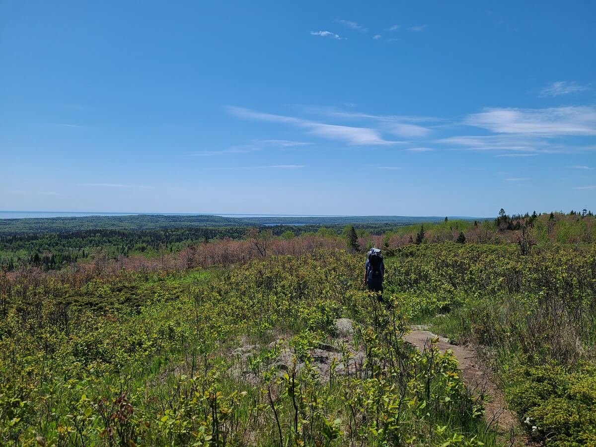
Now that we were on the ridge, there wasn’t any substantial climbing left for the day. This eastern portion of the Greenstone Ridge Trail has many open and exposed sections, which means lots of great views as you hike. In these areas, we really loved the colors of the spring buds at this time of year, too!

Views from the Greenstone Ridge!
After 2.5 miles from Mount Franklin, we came to another great viewpoint along the Greenstone Ridge Trail…Mount Ojibway and the Mount Ojibway Fire Tower. This is a huge exposed area that has great views, and makes for a great resting and lunch spot! You can also climb a little ways up the tower for even better views of the surrounding area. We spent about 45 minutes here, and it was hard to leave, especially knowing that we weren’t even halfway done with our day on the trail yet!

The Ojibway Fire Tower on the Greenstone Ridge Trail

Some of the best views from the Greenstone Ridge Trail!
But, we continued on. From here, the Greenstone Ridge Trail continued to have lots of open views and occasionally, we’d look up to see eagles flying overhead. Up here, there is a lot of exposed granite on the trail, and there are no blazes, cairns, or trail markers of any kind. So it’s important to really pay attention where you’re going here. Kevin is really good with navigation, route finding, and looking for areas of worn rock and vegetation, so we never got off track, but he did agree that it was a bit tough up there.

Walking along the open ridge on the Greenstone Ridge Trail

Eventually, the trail makes its way back to the woods, and it will stay here for pretty much the rest of your time on the Greenstone Ridge Trail. From here, the trail becomes less about amazing views, and more about solitude, wildlife, peaceful forests, and quiet inland lakes, which we loved just as much!
Along this portion of trail, there was actually quite a bit of winter blowdown. This made for lots of obstacles around fallen trees and branches that were hard to maneuver around with big packs, and what made this day more tiring than it should have been! We think that later in the season this wouldn’t be as big of an issue.

Navigating the blowdown on the Greenstone Ridge Trail

While we didn’t have epic views over the island and lake anymore, we really loved the Isle Royale forest and the way the trees lined the path, the quiet solitude, and the wildlife we would frequently stumble upon, such as rabbits, toads, squirrels, and actually, quite a few snakes!


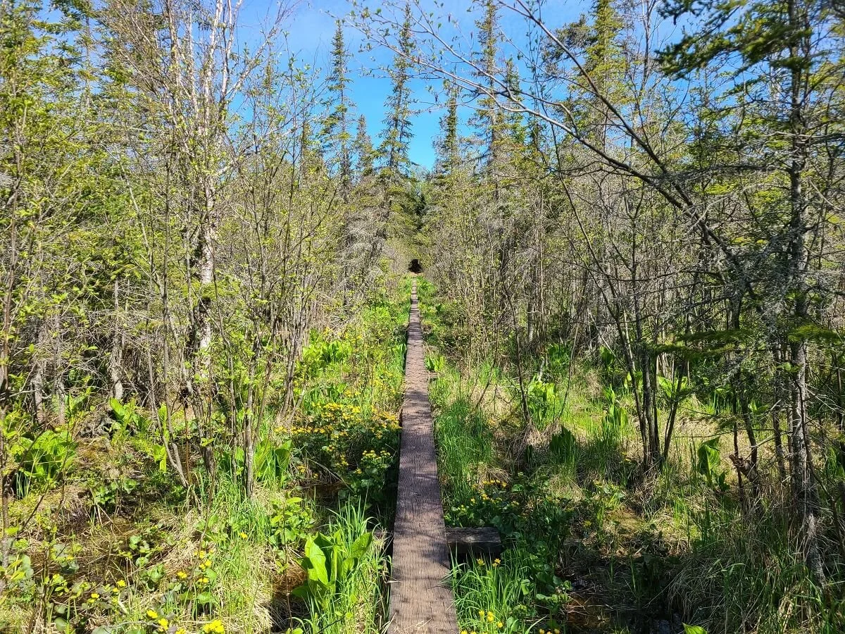
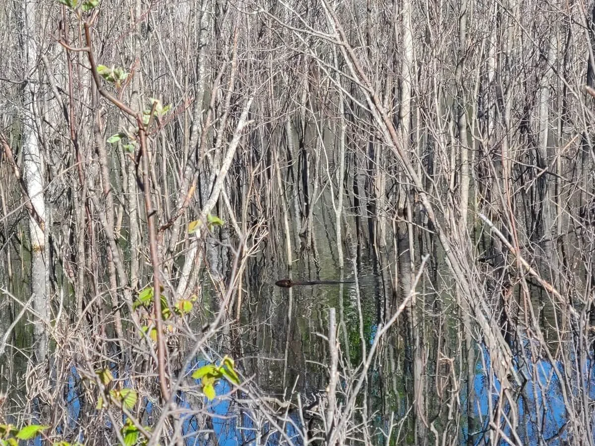
We also walked by several beaver ponds. The first was actually caused by a dam that beavers had built right across the trail itself! Because this caused the trail to be completely flooded out, we had to navigate our way around it and rejoin the trail on the other side. The forest on Isle Royale is thick, and without Kevin’s good navigation skills, I think I probably would have gotten myself lost here. Luckily, on the other side of this pond, there was a rag on a tree that helped us know we were going the right way and we were able to successfully get back on track. We kept hearing giant splashes in the water and we knew beavers were nearby, but we never saw any here. We wanted to hang out to see if we might be able to spot one, but didn’t because here, the bugs (mostly black flies) were soooo bad. It was our first problem with bugs on the Greenstone Ridge Trail (and trust us, it wouldn’t be our last!).

This beaver dam caused a complete reroute of the Greenstone Ridge Trail!
When we got to another beaver pond, we followed a series of wooden planks around to the other side where we passed the Chickenbone East Campground. Just after we passed this, I heard a loud splash and looked over, and had my first ever beaver sighting! It was super exciting, and it felt like a really authentic way to see these guys in their natural habitat out in this remote wilderness.

A beaver!
After a while more on the trail, we came to a weird unmarked intersection that seemed to go in three different directions. The map wasn’t too helpful at first and we got a bit frustrated with the lack of markings, but we saw on the trail that went straight a small sign with a “P” on it and decided to follow it. After this brought us to a lake, it quickly dawned on us that the “P” meant a portaging trail (now you know!). The map did have a small portaging path on it, but on the map, it looked like it went off in a different direction, not straight, which got us a bit confused. We backtracked to the junction and after studying the map a bit more and getting our bearings, we were able to take the right path to continue on the Greenstone Ridge Trail. Later at camp, another hiker said how she was confused here as well, and how she also wandered off on herd paths a lot on the trail. We only had this one issue, but it’s just important to note that since trail markers didn’t exist on the Greenstone Ridge Trail, it’s critical to pay attention and have a map and other navigational tools or experience.
On the final stretch of this portion of the Greenstone Ridge Trail before camp, we were seeing lots of moose prints and were really hoping to see one at some point! Just as I was starting to feel like it wasn’t going to happen today, we saw the biggest moose we had ever seen just ahead on the trail! We stopped in our tracks and observed quietly from a distance, but when it started moving down the trail towards us, we ducked into the forest on the side of the trail…and just in time! We suddenly started hearing loud galloping and before we knew it, the moose bolted down the trail right past us! It startled us for sure, but it was a super cool experience and felt like the most authentic animal encounter we’d ever had. It was just us and the moose out there in this quiet, pristine wilderness.

You’re likely to spot moose while backpacking the Greenstone Ridge Trail!
We finally made it to camp just before 8 pm (so it took us about 9 hours on the trail, but that was with a lot of long breaks at viewpoints along the ridge). It was a bit of a downhill walk to get to the 6 campsites that sit along Chickenbone Lake. We were happy to find one was still free...it wasn’t an ideal one that sat right on the lake, but we were just happy to have our own site! We were also able to find a small rock overlooking the lake where we could make dinner for the night and hang out. We watched the sunset over the lake from here, chatted with a fellow camper, and cooked dinner. It was another very peaceful and quiet camping experience in the wilderness. We fell asleep in our tent to birds chirping and the call of loons over the lake, which is something really cool to hear.

Keep your eye out for these trail markers to campsites along the Greenstone Ridge Trail
Dinner with a view at Chickenbone Lake on the Greenstone Ridge Trail

Overall, this day on the Greenstone Ridge Trail was definitely my favorite! We started off on the beautiful shore of Lake Superior, hiked along a view-filled ridge, saw way more wildlife than people, and fell asleep next to a peaceful inland lake. Can’t get much better than that!
Chickenbone West to Desor South
Today was going to be our longest day of hiking on the Greenstone Ridge Trail…15 miles. Yikes. We definitely had an aggressive itinerary, and if I did it again, I would definitely split this day up by staying at Hatchet Lake.
We got a bit of an earlier start today (just after 9 am), and on our way out of camp, we saw a beaver floating and nibbling right by the shore of the lake! So cool!

We climbed from camp back up to the ridge and began our long hike, which was mostly through the forest today. There were lots of obstacles from blowdown today, still quite a bit of rocky sections that got tough on the feet, and, even though we were still on the ridge, there were lots of steep ups and downs. They came in short spurts so individually they weren’t too bad, but overtime they certainly do add up. We probably ended up doing about 2,000 feet of climbing today just because of these spurts.


Also, the trail today had a few parts that were insanely buggy…probably the worst mix of mosquitos and black flies that we had ever experienced on a trail (well, until we went to Voyaguers shortly after this trip…but that’s for another time…). We definitely needed to break out our bug nets here, even with bug spray slathered on us.
Even though the trail was mostly in the woods, it was still very pretty. And the trail was very quiet again today. We saw maybe five people the whole day just in quick passings.
We eventually made it to Ishmeping Point, which was a bit anticlimactic. There is a small tower here, but the whole point is covered in woods so there are no views from here. Plus, it was still incredibly buggy so we couldn’t stay and rest for long.

The rest of the trail from here was a long march through the forest. Today was definitely my roughest day on the Greenstone Ridge Trail. Between the sheer distance, bugs, and tiring terrain, I was counting down the miles until we landed at our next camp, which was Desor South.

There was still quite a bit of blowdown along this section of the Greenstone Ridge Trail

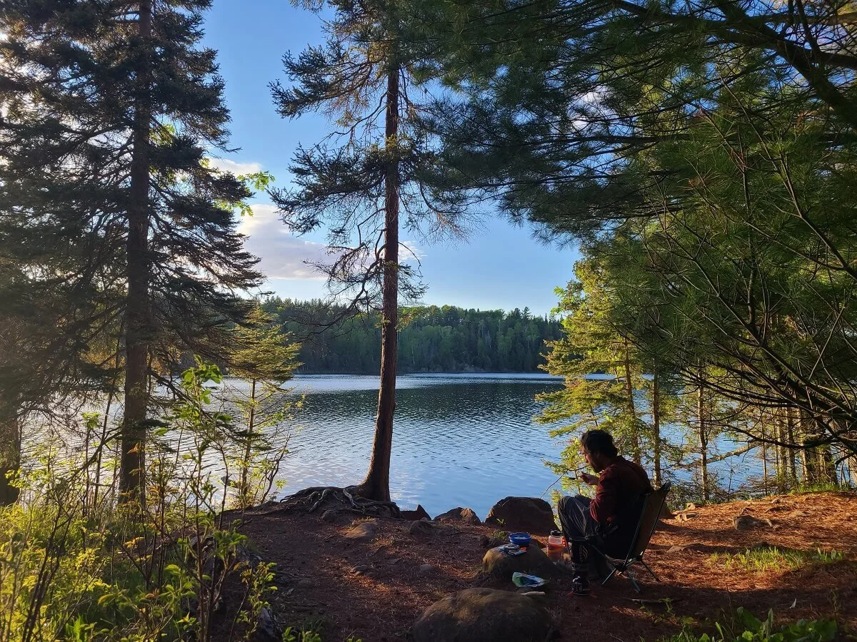
Luckily, the path to camp here was more flat than down off the ridge. We got in just after 8 pm again, and found a few of the 7 tent sites were still open. Again, our site was back from the lake, but we were able to find a spot (although quite muddy) right by the lake to make dinner and filter water. Oh, and here’s a random side note…though this water was safe to filter and drink, the water from this lake tasted particularly bad, and it was a little hard to drink!

Eating dinner and watching the sunset at the Desor Lake campsite on the Greenstone Ridge Trail

Our quiet campsite at Desor Lake
The lake was clear and still, and we watched another peaceful sunset. The only thing that made this night worse than the last is that it was so buggy here like it was on the trail. We couldn’t really sit out and enjoy our site at all this time, even with the bug nets…they were that bad! So we crawled into our tent early and listened to the loons calling again across the lake as we fell asleep.
Desor South to Windigo
It was our final day hiking the Greenstone Ridge Trail! We were a bit sad and didn’t want to leave our peaceful nights behind us, but nevertheless, we set out on the final 11 miles of the hike.
Today’s portion of trail was a bit better than yesterday’s. The trail started by climbing in short spurts up to Mount Desor, the highest point on Isle Royale at almost 1400 feet. It’s rather anticlimactic, actually, as there is no sign that indicates you’re there, and it’s completely wooded without a view. But we knew we were there just based on the distance and elevation that our navigation was reading. Today’s trail was also much more soft dirt and barely any rock, which was a welcome break for our feet.
We saw a bit more people today on the trail than we had in the previous days, as hikers were starting their journeys from Windigo, but everyone was quiet and friendly, and I still felt like we were mostly on our own, going miles without seeing anyone.
We loved the wooded trail today. The woods were so quiet and peaceful and all we heard was just the sound of our own steps on the dirt and birds chirping through the trees, and we were just trying to soak it all up before returning to civilization. We kept saying to each other how much we were enjoying being out here. Normally, I feel like I would find this kind of hike to be boring, but we had just gotten back from a chaotic four months in South America, and I think we both just really needed this reset, and this wilderness was the perfect place to do that. We were just in awe at the actual solitude we were finding out here!

Loving all the greenery on this part of the Greenstone Ridge Trail!

We made it to camp by 5:30 pm after hiking for about 6.5 hours. The Washington Creek Campground in Windigo is pretty big as far as Isle Royale campsites go…it has 5 tent sites and 10 shelters. We were worried again that we weren’t going to find a site here since it’s a very accessible campground and we arrived pretty late, but we were surprised to find all 5 tent sites free and two open shelters! We noticed that all the campsites were very small and rather swampy…not very ideal. So we picked a shelter to stay in, and loved it! It was right along Washington Creek so that we could go to bed and wake up with views of the water, and it also had a picnic table, which was super nice after spending a few days in the woods.

Loving our shelter after finishing the Greenstone Ridge Trail!

After not too long at camp, we saw a moose wade into the creek and cross over to our side and head into the Windigo woods. Later, as we were relaxing at camp, we looked out and saw a pack of otters swimming and playing in the creek! It was so cool to experience this all right from camp.

Otters swimming down Washington Creek!

Campsite visitors in Windigo!
In the evening, the campground descended into silence. We relaxed by the river and just soaked it all in, enjoying the sounds of nature. We watched the sunset as 2 geese and their babies swam around and waddled into our campsite. At night, we loved laying in our shelter being able to look outside and listen to the birds and otters chirping and the buzzing of insects as they awakened for the night. I know it all sounds kind of cheesy and idyllic, but it honestly really was! There’s really no better way to describe it and explain just how much in awe we were of the whole experience of hiking and camping on Isle Royale. Our night in Windigo was the perfect way to end our hike on the Greenstone Ridge Trail and our time on the island.

Evening views from our Windigo shelter
Alternative Ways to Hike the Greenstone Ridge Trail in Isle Royale
As if we haven’t bombarded you with enough route options and Greenstone Ridge Trail itineraries, there is another piece of the puzzle to add to this, but it’s not often done. We still wanted to share it with you in case it would be something you are interested in.
You actually don’t have to start the Greenstone Ridge Trail from Windigo or Rock Harbor. There are a few access points around Isle Royale where you can start hiking and then join up to the Greenstone Ridge Trail. You might not hike the entire length of the ridge doing this, but it still allows for a point- to- point hike where you can hike a good portion of the ridge and see some different scenery.
The Voyageur II ferry out of Grand Portage, MN circumnavigates the island on each of its trips, and with advanced reservations, it makes additional stops beyond Windigo and Rock Harbor. Common drop off points include McCargoe Cove and Chippewa Harbor. If you hike from these points, you’ll end up on the Greenstone Ridge Trail right at Chickenbone Lake, and from here, you can hike to either Windigo or Rock Harbor. From either place, you can take the Voyageur II back to Grand Portage at the end of your trip.
Other options to extend your time on the Isle Royale trails are to add on one of these loops at the beginning or end of your Greenstone Ridge hike:
The Feldtmann Loop- This loop starts and ends in Windigo and gives nice views over Lake Superior from a ridge on the island’s south side. Instead of hiking the portion of the Greenstone Ridge Trail between Island Mine and Windigo, you can take the longer Feldtmann Loop route for better views.
Huginnin Cove Loop- This loop also starts and ends in Windigo and can be added on at the beginning or end of your hike on the Greenstone Ridge Trail. It’s about 9.5 miles so would add on an extra day, but it looks so worth it, as it brings you to an quiet secluded cove along Lake Superior’s shore. This loop is on our list for when we return.
Finally, one last alternative to the standard Greenstone Ridge Trail is to hike the Minong Ridge Trail. This trail parallels the Greenstone Ridge Trail along a lower ridge starting in Windigo and ending at McCargoe Cove where you can then join up with the Greenstone Ridge Trail at Chickenbone Lake. The Minong Ridge Trail is said to be a bit more rugged and challenging than the Greenstone, but it will also provide a bit more views than the Greenstone gives on the western end of the island. Then, once you meet up with the Greenstone Ridge Trail at Chickenbone Lake, you’ll still get to hike the best parts of the trail back to Rock Harbor.
Best Time to Hike the Greenstone Ridge Trail

Your time to hike the Greenstone Ridge Trail is really limited by the transportation services to get to the island. First, the island is only open from April 16th to October 31st due to harsh winters, but most ferries and seaplanes operate only between Mid-May to mid- to late September, so this is the window you have to hike on Isle Royale.
Peak season in Isle Royale is July and August. These months are likely when you will experience full campgrounds, particularly the ones along Lake Superior. If you hike the Greenstone Ridge Trail at this time, expect to see a bit more people on the island and to share some campsites. Despite this, we still heard that you still won’t see that many people on the trails, and the park will still feel quite empty outside of camp, so don’t be too discouraged to come at this time!
In the spring and fall on Isle Royale, the weather can be a bit more variable, and you’ll have to come prepared for anything- cold, wind, rain, snow, etc. But at this time, there will be less people and you likely won’t have to share campsites. We think late summer/ early fall would be the best time to hike the Greenstone Ridge Trail, because it would avoid the bugs, blowdown, and mud that come with hiking in the spring, but you’ll still get the same benefits of low crowds.
What to Pack for Backpacking the Greenstone Ridge Trail
Aside from all the essential hiking and backpacking gear, here are some things we would specifically recommend you bring for hiking the Greenstone Ridge Trail.
Food/snacks- This may seem obvious, but it’s important to know there’s not a whole lot of options to secure backpacking food once you’re on the island. You’ll want to bring with you pretty much all the food you’ll need on the Greenstone Ridge Trail. There is a restaurant in Rock Harbor and some small stores with a few snack options, but definitely not what will sustain you for 4 or more days of backpacking.
A water filter/purifier- The only potable water on Isle Royale is at Rock Harbor and Windigo, and even there, this water may not be available early or late in the season. However, there are plenty of sources you can filter from, including Lake Superior and the inland lakes. The park recommends filtering with at least a 0.4 micron filter plus using additional chemical or UV treatment, or boiling for at least one minute before drinking. Sometimes, toxic algal blooms occur in the park’s inland lakes and the water cannot be consumed at all, so be sure to check the park’s advisories before heading out on the Greenstone Ridge Trail.

Filtering water from Lake Superior at Three Mile Campground
Food storage- There may not be bears on Isle Royale, but we still recommend you bring some sort of hard-sided container like a bear cannister to Isle Royale because there will still be little critters, especially the squirrels, that will try to get into your food. Another option is to store food in double bagged air- tight zip lock bags. This is what we did and had no issues.
Layers- It can be hot during the day on the trails, but at night it can get cool, especially if you come in spring or fall. Bring appropriate base layers for sleeping, and for the different temperatures you might experience along the trail when you’re in the woods versus out on the Lake Superior shoreline.
Rain gear- On an island in the middle of a giant lake, you’ll need to come prepared with anything!
Sun protection- Bring a hat, sunglasses, and sunscreen, especially for days on the exposed ridge.
Bug spray and head net- Especially if you come in June or July, trust us when we say the bugs can get bad. You’ll want these!
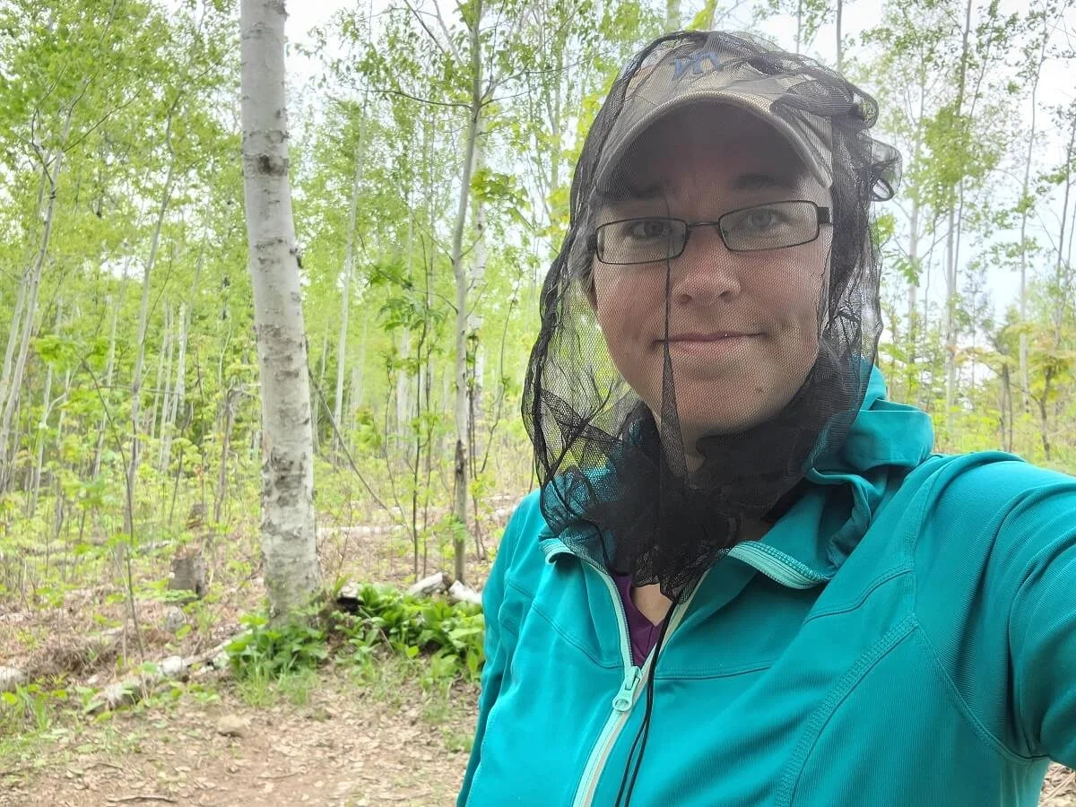
This bug net came in handy!
Toilet paper- All the campgrounds on Isle Royale have outhouses, but they may not be stocked with TP.
Navigation- Have some sort of Isle Royale trail map with you to help you navigate on the trail. It came in handy for us a few times on the Greenstone Ridge Trail where certain junctions weren’t as well-marked as we had hoped, and also just in general for reference throughout the day to help us figure out where we were, how much longer we had, and to help us mentally break up the longer hikes into doable chunks. The National Geographic map is great. We were able to take pictures of maps with trail mileage that were hanging up in the Ranger III ferry, and used these for reference while on the trail.
First aid kit- The Greenstone Ridge Trail can be a bit rough in places (I took a pretty bad tumble over a hidden tree root and definitely had to break out the first aid kit a few times). Help can be a long ways away and the park expects you to be pretty independent and self-reliant in the backcountry. Have a first aid kit and know how to treat common and simple injuries.
Emergency or satellite phone- Because the Greenstone Ridge Trail travels into pretty remote territory on the island, and because cell service isn’t reliable, having a way to reach out in a true emergency is important.
Headlamp- For nights in camp, however we actually rarely needed ours because it didn’t get dark until around 11 pm!
Binoculars or camera with a good zoom- There’s a ton of wildlife on Isle Royale, but you want to keep a safe and respectful distance! Bring along some binoculars or good zoom lens so you can get a closer look without actually getting too close!
Credit card- Cash isn’t accepted on the island, so make sure you bring a card to purchase things like permits, water taxi rides, and food.
Other Things to Know About Backpacking the Greenstone Ridge Trail

Wildlife on the Greenstone Ridge Trail
While you won’t see many people on the Greenstone Ridge Trail, you will see lots of wildlife (our kind of trail!). We saw everything, including hares, toads, squirrels, snakes, beavers, otters, eagles, loons and moose! There are wolves on the island as well, but they are very rare to spot. With any wildlife, make sure to not disturb the animal and keep a healthy distance. Moose are especially commonly seen, but potentially dangerous, animals on Isle Royale. In the spring, females can be aggressive while rearing young, and in the fall, males can get aggressive during mating season, so use caution around them. If they are on the trail, hang back until they decide to move, or try to head around them by going off trail around it.
Cell service on Isle Royale
Don’t depend on having any reliable cell service on Isle Royale. We had it very briefly along the high points of the Greenstone Ridge but that’s it.
Preserving the peace on Isle Royale
We’ve said it a ton here, but the whole reason we absolutely loved hiking the Greenstone Ridge Trail in Isle Royale was because of the solitude we found along the trail and at the campsites. And it seemed like everyone else there was after that same feeling. It was such a pleasant surprise. When you’re in Isle Royale and at the campsites, we definitely encourage you to preserve that peacefulness and tranquility on the island.
More Information for Your Isle Royale National Park Visit
Planning a trip to Isle Royale? Check out our other guides to help you plan your time on the island before or after your hike on the Greenstone Ridge Trail!
ISLE ROYALE GUIDES- Find out everything you need to know about how to visit Isle Royale, including how to get there, where to stay, what to bring, and more, in our complete Isle Royale National Park Guide. Plus, check out all the awesome things to do once you’re there!
ISLE ROYALE HIKING- Looking for day hikes in Isle Royale? Check out our complete guide to learn about our favorites! We also have a separate guide on the popular Scoville Loop Trail out of Rock Harbor. Or, if you’re in search of more backpacking options, check out our guide on backpacking in Isle Royale National Park.
ISLE ROYALE DAY TRIPS- No time for an overnight stay? No problem! Learn how you can still visit the island in our Isle Royale day trip guide.
Planning on hiking the Greenstone Ridge Trail? We hope this guide helps you plan your trip! Hiking the Greenstone Ridge Trail on Isle Royale was one of our favorite backpacking experiences to date and we hope you feel the same way once you’ve done it! Feel free to ask us any questions in the comments below…we love to help!