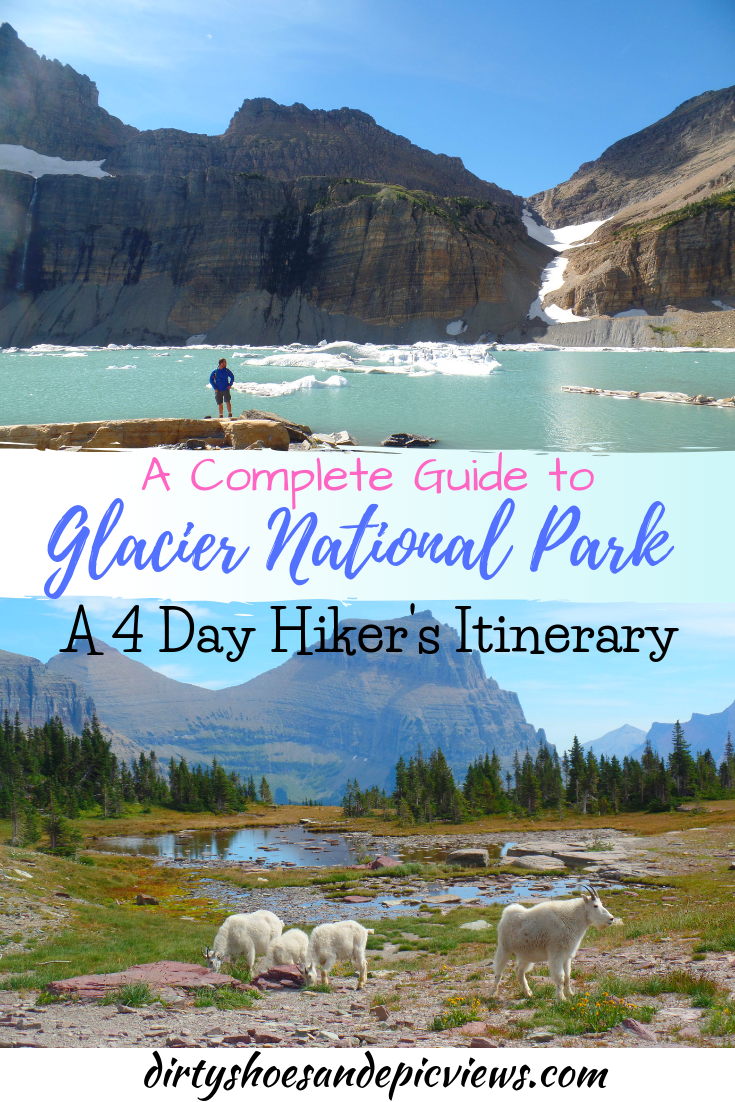
Best Hikes in Glacier National Park: A Complete Hiker’s Guide with Suggested Itineraries!
Looking for the best hikes in Glacier National Park? Let’s be honest…there are too many amazing ones to count! But here, we want to share with you some of our favorite Glacier hikes. We’ll also give you suggestions for some Glacier National Park hiking itineraries and all our best tips for visiting the park so that you can have the perfect one to four days on the trails in Glacier.

Glacial-fed electric blue lakes, historic chalets with epic views, some of the most scenic trails in North America….need I say more?
Glacier National Park is often called the Crown Jewel of the Continent, and after experiencing some of the trails in Glacier ourselves, we 100% agree with the nickname!
The scenery in this park is simply jaw-droppingly gorgeous, and you can see a good chunk of it right from the comfort of your car as you drive the famously scenic Going to the Sun Road that crosses the heart of the park.
But why stop there?
There are over 800 miles of hiking trails in Glacier National Park that will get you into the backcountry to find hidden lakes, mountain-top views, and epic scenery that you just can’t quite get from the car. In fact, some of our favorite hikes and views ever have been right here on the Glacier National Park trails.
So what are the best hikes in Glacier National Park? Well, to be honest, there are sooooo many amazing ones. You could spend a week here like we did and still leave feeling like you haven’t even scratched the surface. But the good news is that you really can’t go wrong. So if you have a limited time and can pick just one or two hikes in Glacier National Park, you’re likely still going to get those epic views that the park is so well-known for.
But to help you narrow down your options and make it a little less overwhelming for you, we’re sharing our absolute favorite hikes in Glacier National Park. We’ll go over our ten favorite Glacier hikes organized by the region of the park that they’re found in, plus show you how you can plan an amazing 4 day Glacier National Park itinerary filled with some of the most epic hikes in Glacier.
In this Glacier National Park hiking guide:
Regions with the Best Hikes in Glacier National Park
If you want to hike in Glacier National Park, it’s good to know that Glacier has several different main regions, each with their own collection of unique hikes and facilities. We’ll give a brief overview here to help you get oriented as to where all our favorite Glacier National Park hikes are located.
Going to the Sun Road

Many great Glacier National Park hikes are found along the Going to the Sun Road
Driving the Going to the Sun Road is the must-do activity (other than hiking, of course!) in Glacier National Park.
This road cuts through the heart of Glacier National Park and is the only road that connects the east and west sides of the park. Oh, and it’s incredibly scenic. Right from your car, you get gorgeous views of glaciated mountains, lakes, and valleys, but it also has trailheads for some of the best hikes in Glacier National Park.
Getting here: You can start the Going to the Sun Road either at West Glacier on the west or at St. Mary on the east. Plan on getting to trailheads early to guarantee parking (or, alternatively, hop on the free Glacier National Park shuttle - but still get there early to avoid long lines!). Point-to-point, the Going to the Sun Road is about 50 miles and takes two hours to drive without stopping.
Where to stay along the Going to the Sun Road: While there is no lodging or camping at the popular Logan Pass area, there are numerous campgrounds (mostly reservation-based) and lodging options along the road, particularly in Apgar, Lake McDonald, Avalanche, and Rising Sun areas.
The Going to the Sun Road itself has several major noteworthy regions that we’ll outline here:
Apgar/Lake McDonald region
The Going to the Sun Road begins in West Glacier on the west side of the park. Shortly after the start of the road, you’ll arrive in Apgar, a village at the foot of the famous Lake McDonald that has lodging, camping, tours, a visitor center, a restaurant, and gift shops.
Lake McDonald itself is one of the most photogenic spots in Glacier National Park. It’s a great place to relax or paddleboard and take in the views, but several noteworthy Glacier National Park hikes begin in this region.
Logan Pass
Logan Pass is the highest point along the Going to the Sun Road and is a super gorgeous, and super popular, part of the park. Getting here early is key to finding parking because it’s the start of lots of good hikes in Glacier National Park (such as the famous Hidden Lake and Highline Trails).
St. Mary
St. Mary marks the eastern- most end of the Going to the Sun Road. Between Logan Pass and St. Mary, there are a few noteworthy Glacier hikes. When we visited the park, this end of the Going to the Sun Road was a little less crowded compared with the Lake McDonald and Logan Pass areas, but don’t get me wrong, there will still be lots of people!
Many Glacier

Glacier’s best hikes are found in the Many Glacier region!
Many Glacier is an insanely beautiful region of the park. Many people think it’s even better than the Going to the Sun Road! We agree, because it has our personal favorite hikes in Glacier National Park! And there are plenty of facilities here including lodging, camping, places to eat, and boat and bus tours.
It’s slightly out of the way from the main Going to the Sun region, but if you have a few days in the park, we highly suggest devoting at least one of them to Many Glacier.
Getting here: From the St. Mary entrance to the Going to the Sun Road, the Many Glacier entrance lies just over 8 miles north along route 89, at the town of Babb. The road into Many Glacier is about 12 miles long but it’s just about the best scenery you can get from the comfort of your car!
Where to stay in Many Glacier: There is one campsite in Many Glacier that will put you right next to the best hikes in Glacier. It requires reservations up to 6 months in advance, but lately, these book up as soon as they open.
There are also options to camp just outside of the park. We stayed at both Johnson’s RV Park, and Chewing Blackbones Campground. Both were simple, standard campsites recommended to us by park rangers.
The Chewing Blackbones Campground is especially nice because it sits next to Lower St. Mary Lake. The sites next to the lake were secluded and shaded with trees, but all other sites were in an open field, so we would recommend getting one of the sites next to the lake. Our little site had a trail that gave us our own little private section along the lake to relax and eat dinner by! When we were there, the campground was almost completely empty…so it was quiet, and we weren’t that far from the hikes in Glacier National Park that we wanted to do either, so it worked out pretty well!
Many Glacier does also offer a couple of inn/hotel options, including the epic Many Glacier Hotel that has stunning views into the valley. Outside of the park, your closest option for finding lodging is in Browning, which is about an hour away from Many Glacier.
Two Medicine

Some off- the- beaten- path hikes in Glacier can be found in the Two Medicine area
The other region on Glacier National Park’s eastern side is Two Medicine. Two Medicine is a more remote and much less visited section of the park. There’s no lodging, restaurants, or visitor centers here, just a ranger station, campground, and small camp store.
If you’re looking for a hike in Glacier National Park with solitude and few people on the trail, the Two Medicine region should be on your list. There are several long day hikes that start from Two Medicine, and from our experience, these Glacier trails offer an amazing amount of solitude but with equally breathtaking scenery as other more popular areas of Glacier National Park.
How to Get to Two Medicine: From the St. Mary entrance at the Going to the Sun Road on the east side of the park, the entrance road to Two Medicine lies about a half hour south (18.5 miles). At this point, you’ll take a right onto MT- 49. From here, it’s an almost 15 mile journey down to the Two Medicine area that slowly switchbacks down into the valley. After about 7.5 miles on MT-49, take a sharp right onto the Two Medicine entry road, which will take you the rest of the way in.
Where to Stay in Two Medicine: There is one campground in the Two Medicine area that is reservable up to 6 months in advance. Since this part of Glacier is not as visited as the Going to the Sun Road and Many Glacier, you’ll probably be able to get a reservation here pretty easily.
There are no lodging facilities in this part of the park, or restaurants (just a camp store), which is pretty cool because it has a more of the off-the-beaten path, less crowded feel to it…a welcome change of pace from other areas of the park!
If you aren’t looking to camp, check out the town of Browning for accommodations, which is about a half hour away from Two Medicine.
Can you hike in Glacier National Park without reservations?
Given that each of these regions with the best hikes in Glacier now require reservations, there is a layer of complexity involved with planning a trip to Glacier!
If you plan on visiting multiple regions of the park to hike in Glacier, it requires coordinating up to four different reservation processes. If that’s not something you want to deal with (and we don’t blame you!), or if you simply couldn’t snag one of the highly sought after reservations that you wanted, is it still possible to hike in Glacier?
Yes! Even without a reservation you can still access the trails in Glacier. The reservation requirements are flexible enough to allow people in without one, you’ll just have to be a bit more flexible in your schedule and timing.
Here are four different ways you can hike in Glacier without a reservation:
Go at the right time of year. Reservations are not required at most entrances before July 1st and after September 10th, so it’s possible to hike in Glacier without a reservation outside of these dates. However, I wouldn’t necessarily plan your entire trip to hike in Glacier outside of these dates because, depending on the year, snow can linger late in the spring and start early in the fall and could keep trails and roads closed. If you do use this as your main method for hitting the trails in Glacier, keep your fingers crossed! Be sure to check trail and road conditions as well.
Go at the right time of day. During the reservation period, you can access Glacier without a reservation before 6 am and after 3 pm. If you’re an early bird, getting to the park before 6 am to hit the hiking trails in Glacier is a great idea anyway to try and beat crowds and snag parking spaces. This is especially true for areas on the Going to the Sun Road, such as Logan Pass. Last time we were in Glacier, we spoke to people who said there were still massive lines at the Going to the Sun Road entrance gates well before 6 am…yikes! So the earlier you can get there, the better.
Starting the Going to the Sun Road after 3 pm is also a possibility, especially if you don’t plan on doing a huge hike in Glacier. In the summer, days are very long (daylight can last as late as 10 pm!), so you will still have a lot of sunlight to work with and you can still fit in a couple of short hikes in Glacier along the Going to the Sun Road. Coming later will also allow you to avoid the worst of the crowds. When we were in Glacier last, we headed into the park at about 5 pm and were still able to do the Hidden Lake Trail and the Sunrift Gorge Trail before it got dark, and the park didn’t feel very crowded at all, so it was great!
Even heading into Many Glacier after 3 pm is a possibility. You can start one of the amazing hikes in Glacier here by about 3 pm or so and still have enough time to finish before it gets too dark outside.
Have a service reservation. Another way you can get access to hikes in Glacier without reservations is by having a service reservation (such as a campground, lodging, or boat tour reservation). This service reservation includes the park reservation, and will only be valid for the region that the service is in (i.e. campground reservations in Many Glacier will not get you access to the Going to the Sun Road and vice versa) and only for the days your service is good for.
Take the shuttle. Lastly, you can still access the hikes in Glacier along the Going to the Sun Road without a reservation by taking the park shuttle! Because road reservations are not checked until the Rising Sun entrance gate, you can still access the St. Mary visitor center and shuttle stop on the east side of the park without a reservation. We would still recommend an early start here to avoid long waits to get on the shuttle.
Best Hikes in Glacier National Park: Going to the Sun Road
Now that you know where all our favorite Glacier hikes are found, let’s go over our top ten favorites!
We’ll start our list of best hikes in Glacier National Park with the most popular area…the Going to the Sun Road.
The Going to the Sun Road is the crown jewel of the continent’s crown jewel. With stunning scenery just from the comfort of your car, you can only imagine what the views will be like along the trails.
A map of hikes in Glacier National Park along the Going to the Sun Road

Map of the east end of Going to the Sun Road taken from the NPS. Our list of best hikes in Glacier National Park on the Going to the Sun Road are highlighted in blue.
Hidden Lake
Distance: 2.8 miles roundtrip
Elevation Gain: 460 feet
Trailhead: Logan Pass
Trail type: Out and back
Level: Easy
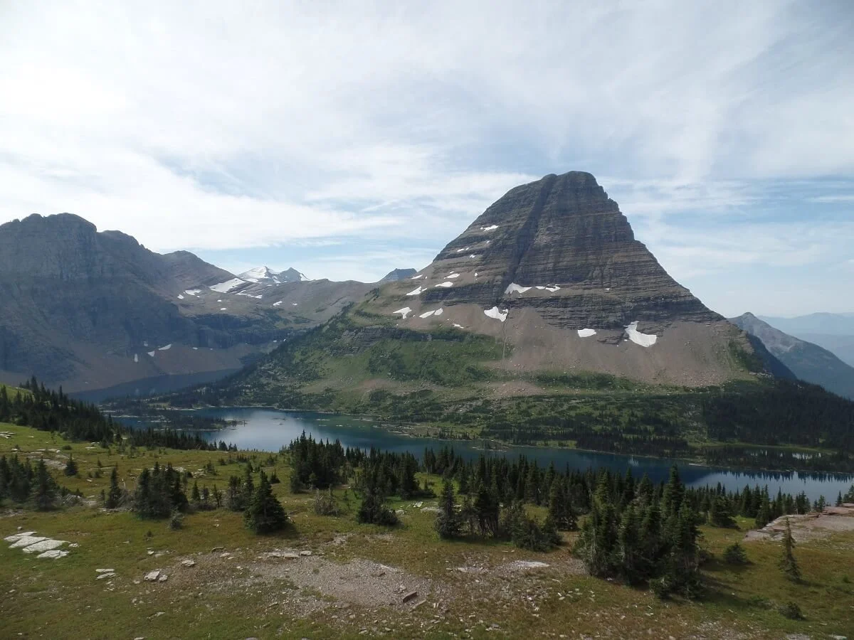
A famous view from the Hidden Lake Trail in Glacier National Park
Fun fact: If your goal when hiking in Glacier National Park is to see mountain goats (and why wouldn’t it be?!), head straight for the Hidden Lake trail.
Hidden Lake actually wasn’t in our original plans on our first trip to Glacier. But after we had crossed off all our other must-do Glacier National Park hikes and were getting ready to head out the next morning, I felt a little jipped that we were going to leave without seeing any mountain goats!
Throughout our time in Glacier, we chatted with people here and there, and many told us that they had seen mountain goats at Hidden Lake and that they are pretty much always there. So that night, I made the executive decision to stay in Glacier for one more day and make the trip back to Logan Pass to find them. And guess what…it was so worth it! We saw so many of them!
The Hidden Lake Trail is a very easy hike in Glacier National Park. The first part is actually just a boardwalk that makes a very gradual ascent (but there are quite a few stairs!).
This Glacier hike has some of the best views along the Going to the Sun Road!
Because of its ease, accessibility, and location, you better believe it will be crowded. Getting to this Glacier hike on the earlier or later side will be helpful in finding parking at Logan Pass and avoiding the heaviest crowds.
As you’re walking along this Glacier trail, keep your eyes peeled and hopefully you’ll see some mountains goats in all their majestic glory off on the hills doing mountain goat things, and if you’re lucky, they’ll be right by the trail!
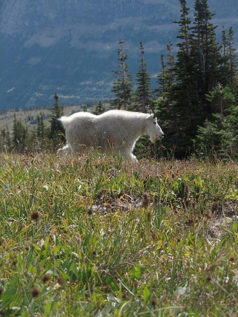


Seeing mountain goats on the trails in Glacier was one of our favorite experiences in the park!

This guy was posing for us!
Aside from the whole mountain goat thing, the scenery is gorgeous the entire way, and the overlook of Hidden Lake is quite picturesque (literally, this picture is everywhere!). There’s definitely a reason this is one the most popular hikes in Glacier!
If you want a longer hike, there is an option (which was closed when we were there) to walk a little over a mile and 780 feet down to the shore of Hidden Lake if you want a closer look.
Overall, I highly recommend this hike in Glacier National Park….it’s quick, it’s easy, it has some of the best views in Glacier, and it has goats! Just expect crowds…but this is one Glacier hike that’s worth those crowds.
The Highline Trail
Distance: 11.8 miles point- to- point
Elevation Gain: 700 feet when hiking Logan Pass to The Loop; 2200 feet when hiking The Loop to Logan Pass
Trailhead: Logan Pass or The Loop
Trail type: Point-to-point or out and back
Level: Moderate when hiking from Logan Pass to the Loop, solely because of the longer distance.

View from the Highline Trail in Glacier National Park
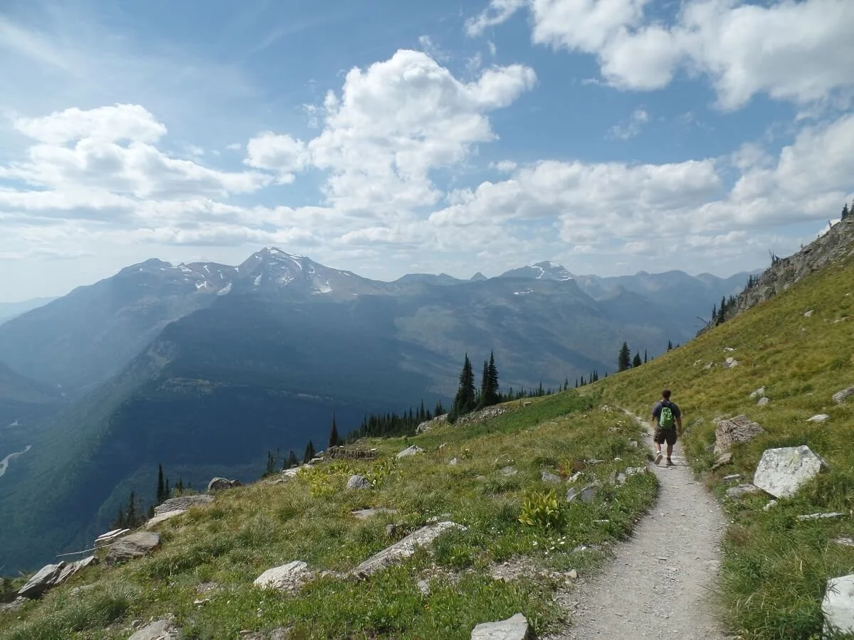
The Highline Trail is arguably the most famous hike in Glacier National Park, and rightly so. While this came as a close second to my absolute favorite hike in Glacier (which we mention below), we would still say that if you have only time for one hike in Glacier National Park, this is the one I would recommend.
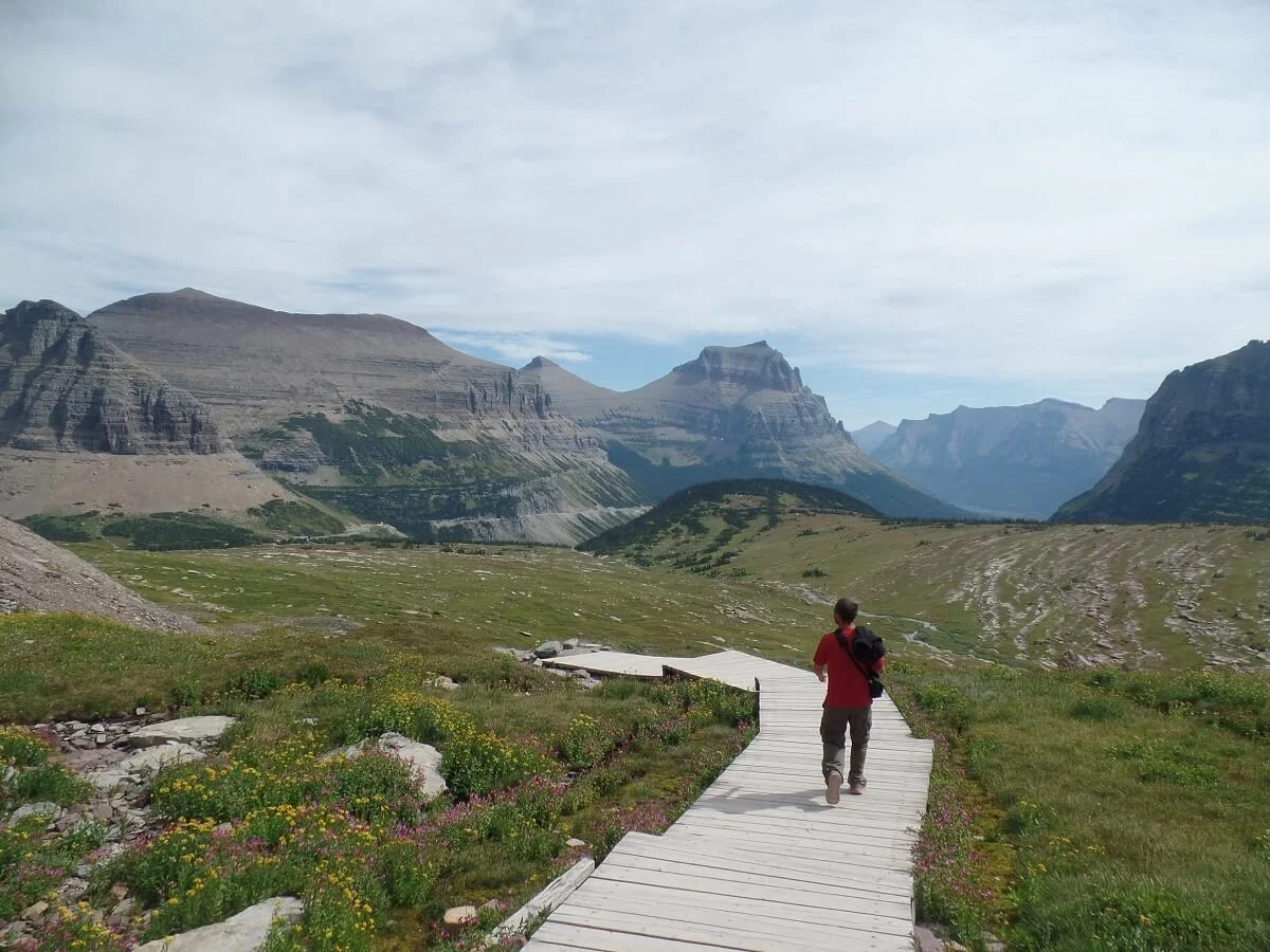
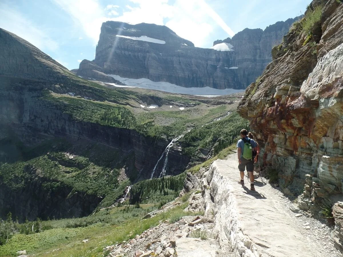
This hike traverses right through the heart of the park along the Garden Wall (the name of the portion of the Continental Divide that runs through the park), and the epic scenery is constant. Seriously, it never stops. From your very first steps from Logan Pass, you’ll be in awe of the views, and they just get better from there.

The Highline Trail proper is a point-to-point hike, spanning almost 12 miles from Logan Pass to the Loop along the Going to the Sun Road. This is where the Glacier National Park shuttle comes in handy, so that you can get shuttled back to your car after you complete the hike. However, if you don’t want to deal with the logistics of a one way hike, or just don’t want to do the longer distance, you can simply start at Logan Pass and do the hike as an out and back to one of several worthy points along the trail.
Here’s a quick trail summary to give you an idea of what to expect along this epic Glacier National Park hike:
You’ll start the Highline Trail right across the street from Logan Pass. Shortly after Logan Pass, there’s about a quarter mile section of trail that forms a ledge carved out from the mountainside. There is a bit of exposure here, but a rope runs along the rock wall to give you some sense of comfort. It might make those with a fear of heights a little nervous, but it’s totally doable, as the ledge is pretty wide, and it makes for some epic shots!
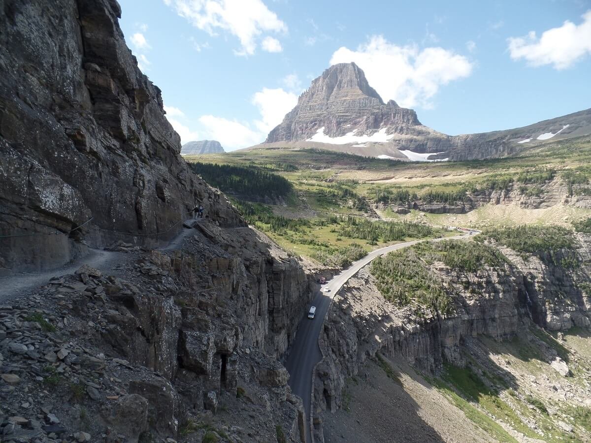
The rope section of the Highline Trail is part of what makes this one of the most sought- after hikes in Glacier!
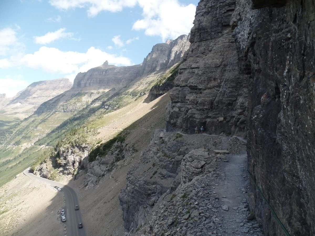
A view from the ledges along the Highline Trail, with the Going to the Sun Road just below!
From here, you’ll make the gradual climb up to Haystack Pass, which is a good turnaround point for those not choosing to do the entire Highline Trail.
However, if you’re doing a point-to-point hike from Logan Pass, you’ll continue past Haystack Pass onto the Granite Park Chalet and finally down to The Loop along the Going to the Sun Road. Along the way are tons of phenomenal views and some awesome side trails if you have the time and energy. And because the trail is so long and many people just do an out and back hike to Haystack Pass, we found that this part of the trail, especially beyond Haystack Pass, didn’t feel too crowded.
Be sure to check out our Highline Trail hiking guide for tons of useful information on how to prepare for this epic Glacier hiking trail! Although it’s very popular and well-known, we do feel that this is one hike in Glacier National Park that lives up to the hype and needs to be on every hiker’s list.
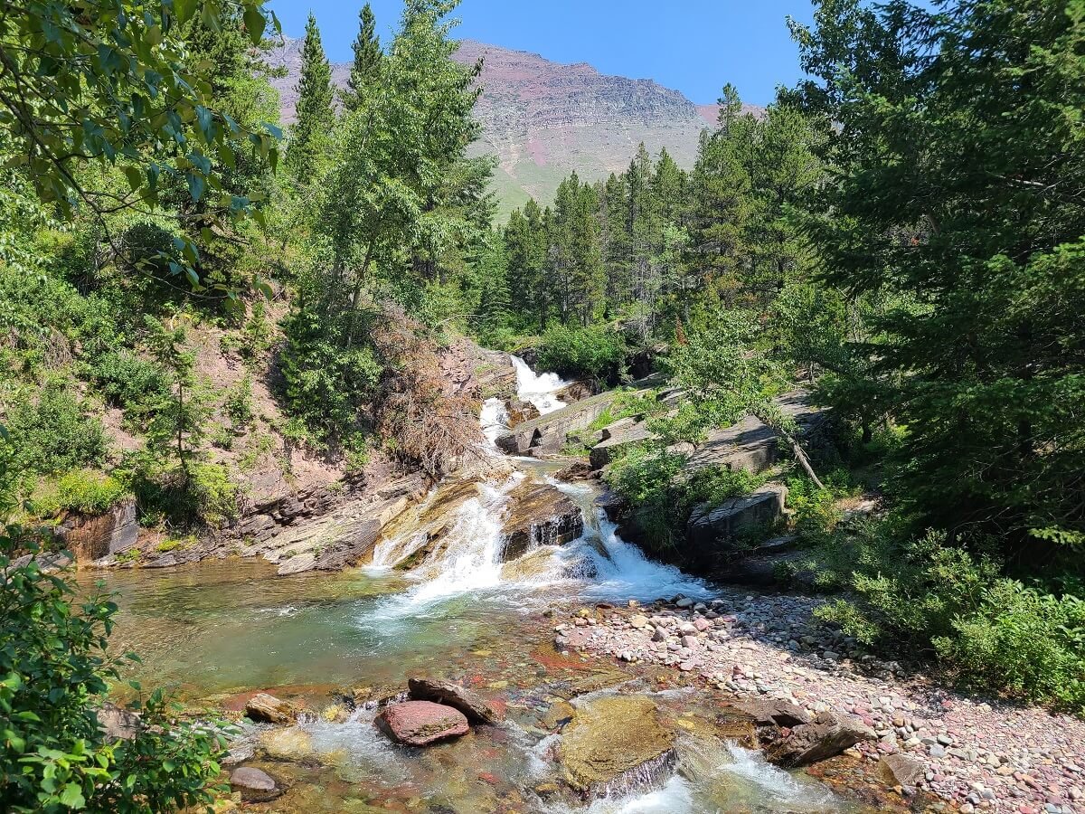
St. Mary Falls
Distance: 1.6 miles roundtrip
Elevation Gain: 260 feet (on the way back)
Trailhead: St. Mary Falls Trailhead (see below for others)
Trail type: Out and back
Level: Easy

The St. Mary Falls trail is a great option for an easy out and back hike in Glacier National Park. It’s short, pretty flat, and brings you out to a beautifully blue waterfall. It doesn’t have quite the same “wow” factor as some of the other hikes in Glacier on this list if you’re looking for epic mountain views, but it’s a nice quiet walk through a beautiful forest, and a good option for a hike in Glacier if it’s a rainy or gloomy day. Plus, when we were there, it wasn’t crowded at all. In fact, we saw only two other parties on the trail.
This Glacier hike weaves through the thin regrowth from a 2015 forest fire, and the contrast of charred black trees among blossoming purple wildflowers makes for a very unique walk.
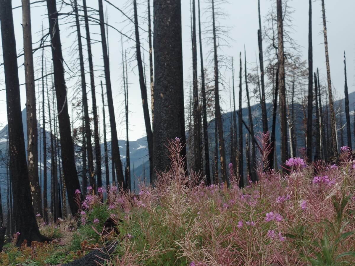
Beautiful purple flowers along the St. Mary Falls Trail in Glacier

After a short time, the trail brings you to a small bridge which provides the perfect view point of St. Mary Falls while standing over a river of milky blue water.


If you want to double the distance of this hike, you can continue another 0.8 relatively flat miles to Virginia Falls. I’m not really sure why, but we didn’t continue on to this one! It looks like a cool waterfall though if you’re looking to extend the hike a bit.
There are several spots to start the St. Mary Falls hike that vary in distance:
St. Mary Falls trailhead- This is the most direct and shortest option to hike to St. Mary Falls and is what the stats above describe.
Sunrift Gorge parking area- Starting here will add some distance but you will walk through more of the forest along the shore of St. Mary Lake and also see another waterfall…Baring Falls, which we talk about below!
Sun Point Nature Trail- This is the longest option for hiking to St. Mary Falls. Starting here will add 1.6 miles more of easy hiking from Sunrift Gorge, but it will also take you to a beautiful overlook along St. Mary lake. From here, you’ll continue on past Baring Falls and onto St. Mary Falls.
No matter which trailhead you start from, this is a wonderfully peaceful hike in Glacier National Park and a good escape from the crowds who are all at Logan Pass or Many Glacier!
Sun Point Nature Trail to Baring Falls (and the Three Falls Trail)
Distance: 1.6 miles roundtrip to Baring Falls with options to extend
Elevation Gain: Approximately 200 feet
Trailhead: Sun Point
Trail type: Out and back (or can be done as a point-to-point using the park shuttle)
Level: Easy

View from the Three Falls Trail in Glacier National Park
Sun Point is a very popular overlook along the Going to the Sun Road, but it is also the start of a scenic yet easy hike in Glacier National Park that can take you to up to three waterfalls!
After enjoying the views at the overlook, start on the Sun Point Nature Trail at the west end of the parking lot. The trail begins by going through the sparse forest left behind by the Reynolds Fire in 2015. It hugs the side of St. Mary Lake, so you’ll get views along the trail through the thinned forest and beautiful purple wildflowers. The trail has small ups and down as it traverses the lakeside, but nothing strenuous.
After 0.6 miles, you’ll stumble upon Baring Falls, an unexpectedly cool little waterfall that still seems to be hidden from the masses. In fact, we were the only ones here at the falls and on this Glacier National Park trail (it was close to sunset, though, which might be why).

The bridge in front of Baring Falls in Glacier National Park
A rough windblown trail on the right side of the foot bridge that crosses the stream leads you to the base of the falls (don’t expect to stay dry here!).

Walking the sketchy path to the side of Baring Falls

You can turn around here or, if you wanted to make this a point-to-point hike, you can hike to the nearby Sunrift Gorge shuttle stop and catch the short shuttle ride back to Sun Point.
However, you can actually extend this Glacier hike and keep going past Baring Falls to continue along the Three Falls Trail and hit a few more Glacier waterfalls!
The Three Falls Trail
The Three Falls Trail in Glacier starts at the Sun Point parking lot and goes by Baring Falls, but then continues on to both St. Mary Falls and Virginia Falls.
From the Sun Point parking lot, the hike to St. Mary Falls is 2.1 miles one way (so 1.5 miles past Baring Falls on the Three Falls Trail) and involves a small climb up and over an exposed trail to some awesome viewpoints alongside St. Mary Lake. After visiting Baring Falls, we continued on and hiked this trail to its highest point because we could never get ourselves to turn back around…the view kept getting so good!

Standing on the edge of St. Mary Lake just past Baring Falls on the Three Falls Trail
We did this Glacier National park hike around sunset, which we highly recommend, because the way the sun was glowing off the lakeside cliffs was so gorgeous!

Sunset from the Three Falls Trail in Glacier National Park
We did end up turning around, though, before getting to St. Mary Falls, because we had already hiked there from the St. Mary Falls trailhead on a previous trip to Glacier.
From St. Mary Falls, you can continue onto Virgina Falls, which is an extra 0.8 miles and about 250 feet of climbing.
Roundtrip, the full Three Falls Trail from Sun Point to Virginia Falls and back is 5.6 miles, or you can make it a point-to- point by hiking back to the St. Mary Falls trailhead after Virgina Falls and taking the shuttle back to Sun Point.
Other options for hikes in Glacier along the Going to the Sun Road with more time
There are plenty of other options for hiking in Glacier along the Going to the Sun Road that we just didn’t have the time for, but some of these are definitely on our list for next time!
Siyeh Pass – A challenging hike in Glacier that leads to stunning valley views. There are multiple ways to get to this pass, including a 4.6 mile one - way trip from the Piegan Pass trailhead that gains 2,240 feet, or a 5.5 mile one - way trip that gains 3,440 feet from the Sunrift Gorge pullout.
Piegan Pass - Located near Siyeh Pass, this Glacier hike is 4.5 miles with a gain of 1,750 feet from the Piegan Pass trailhead. You can continue on another 8 miles or so to reach the Many Glacier area of the park.
Gunsight Pass – This is a roughly 19 mile trail in Glacier that connects St. Mary valley to the Lake McDonald area, and is on our list of hikes in Glacier to do on our next visit! This one will require some logistics with the shuttle to make it a point-to-point hike.
Avalanche Lake - This is a popular hike in Glacier that leads to a beautiful glacier lake. It’s 2.8 miles with 500 feet of elevation gain.
Mt. Brown Lookout - This is a steep hike in Glacier that provides a view over Lake McDonald. This hike is 10.4 miles round trip with 4,325 feet of gain.
Lake McDonald – A trail straddles the west side of the lake for approximately 9 miles and is mostly level for an easy walk that provides different perspectives of Lake McDonald.

You don’t have to walk the trail to visit Lake McDonald, though. We visited the lake in the evening after we finished the Highline Trail as a nice peaceful and quiet way to end our day on the trails in Glacier National Park.
Best Hikes in Glacier National Park: Many Glacier
The Many Glacier area of the park is so gorgeous, and actually has our favorite hikes in Glacier National Park! With stunning mountain backdrops, and valleys filled with lakes that look like they could be the source of the blue Gatorade drinks, you should definitely put this area on your Glacier National Park itinerary if you’re looking for an amazing hike in Glacier.
Map of hikes in Glacier National Park in Many Glacier

Map of the trails in the Many Glacier area from the NPS. Our favorite hikes in Glacier National Park in Many Glacier are highlighted in blue.
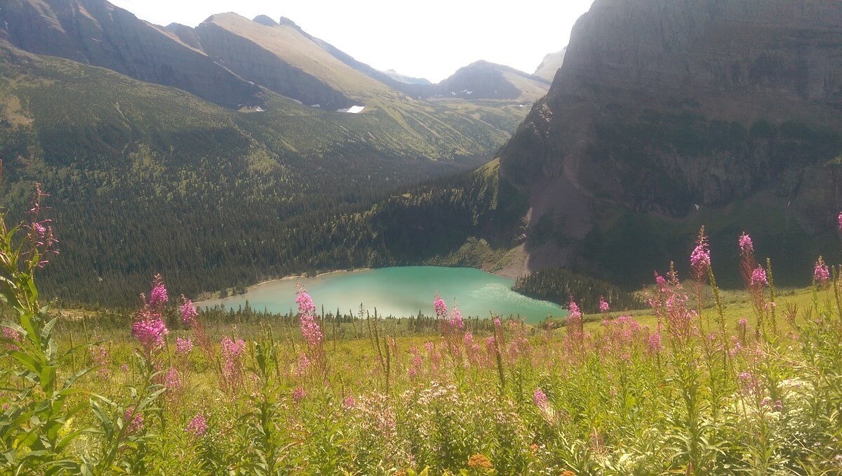
Grinnell Glacier
Distance: 10.6 miles roundtrip
Elevation Gain: 1600 feet
Trailhead: Grinnell Glacier Trailhead (just before the campground)
Trail type: Out and back
Level: Moderate – for distance only. It’s an easy-to-follow, very popular trail with slow elevation gain. Some narrow cliffside trail sections might be challenging for some.

Views like these are what made Grinnell Glacier one of our favorite hikes in Glacier National Park!
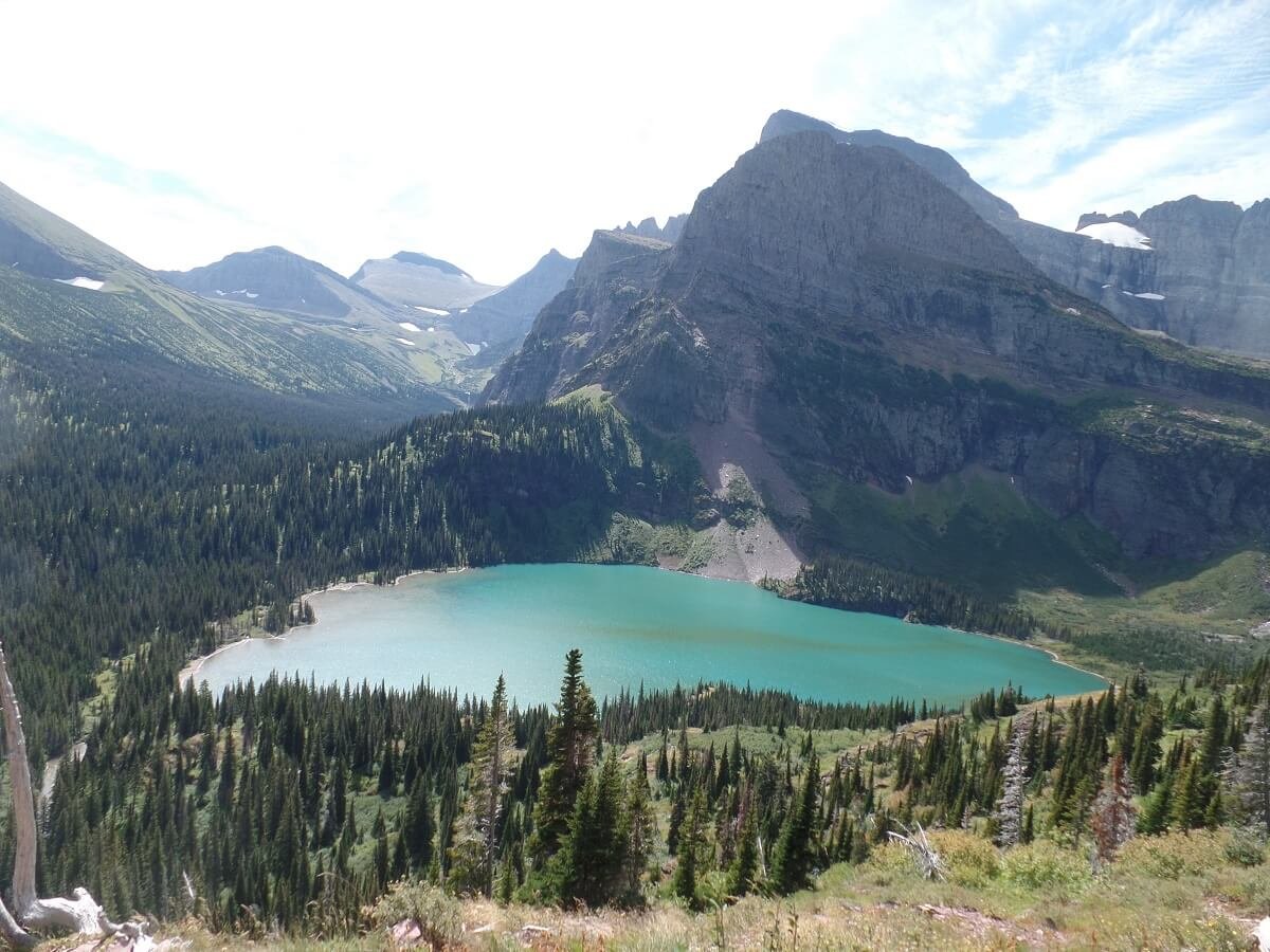
The Grinnell Glacier hike in Glacier National Park has it all…views, lakes, glaciers, wildlife, waterfalls, wildflowers…which is why it’s our favorite!
This Glacier hike starts at the base of Swiftcurrent Lake and climbs gradually up out of the valley on its way to Upper Grinnell Lake. On the way, you get jaw dropping views of the mountains and over the stunningly blue Lower Grinnell Lake that will make you feel like you’ve been transported to a fairytale.
This Glacier hike is packed with amazing views

The Grinnell Glacier trail does have some areas that might make someone with a fear of heights or narrow ledges feel a little uncomfortable, as parts of the trail are carved along the mountain side as ledges with some minor exposure. These sections are very brief, and we never felt unsafe here. Plus, the views will help distract you!
One of the more exposed ledges along the Grinnell Glacier Trail…but look at those views!
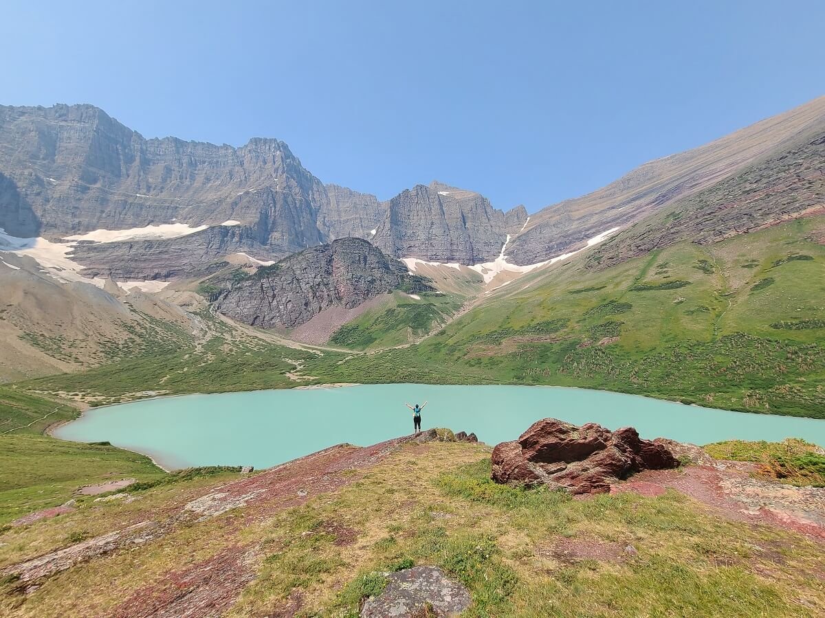
The reward at the top of this Glacier hike is a front row seat to the milky blue shores of Upper Grinnell Lake sitting at the base of the continental divide. You’ll also get a glimpse at the quickly disappearing Salamander and Grinnell Glaciers, and a glacially fed waterfall flowing down into the lake.

Standing on the edge of Upper Grinnell Lake!
Overall, the Grinnell Glacier hike in Glacier National Park is a really high bang-for-your-buck hike and we highly recommend putting this one on your Glacier hiking itinerary!
Cracker Lake
Distance: 13.17 miles roundtrip
Elevation Gain: 1900 feet
Trailhead: At the parking lot for the Many Glacier Hotel
Trail type: Out and back
Level: Moderate – for distance only. Overall, it has a gradual elevation gain and no tricky trail elements.
Cracker Lake was one of our favorite hikes in Glacier
The Cracker Lake hike in Glacier is a true stand out…and that’s saying something in a park full of breathtaking scenery and glacial lakes.
Not only is there an epic lake at the end, but this Glacier National Park hike gives a good opportunity to experience some solitude on the trail and to see some cool wildlife! It’s a long hike, but totally worth it!
The first part of the Cracker Lake hike is flat and fast through the woods around Sherburne Lake, followed by a climb up some switchbacks into the open valley that Cracker Lake sits in. From here, the views get good as the jagged mountains start to show themselves. As you hike through the moraine area, be sure to keep an eye out for pika and marmots!

When you finally make it to the Cracker Lake, you’ll probably have to pick your jaw up from the ground because it is so gorgeous. The contrast of the bright greens and blues of the landscape were like nothing we’d seen before. We stayed here for several hours just taking it all in. Plus, we got to watch cute ground squirrels scurrying around and observed a moose on the far side of the lake!

Overall, we highly recommend the Cracker Lake hike in Glacier National Park if you’re looking for an epic glacial lake but without some of the heavy crowds of the more popular hikes in the Many Glacier area.
Iceberg Lake
Distance: 10 miles out and back
Elevation Gain: 1460 feet
Trailhead: Near the Swiftcurrent Motel
Trail type: Out and back
Level: Moderate – for distance only. Like the Cracker Lake hike, it has a gradual elevation gain and no tricky trail elements.

An epic glacier lake awaits you at the end of the Iceberg Lake Trail in Glacier!
Iceberg Lake is a popular hike in Glacier National Park, but for a good reason! This hike is relatively easy…it’s long, but never difficult. Plus, the entire trail provides epic views over the Many Glacier valley. Combine that with the fact that it ends at an iceberg-filled lake with a gorgeous mountain backdrop, and you’ve got yourself one of the best hikes in Glacier National Park!
Most of the Iceberg Lake hike follows a relatively easy-going trail along the valley ridge, with nonstop views of the mountains that make up Many Glacier.

You get stunning views from this Glacier National Park trail!
At the end of this Glacier hike, you’ll enjoy views of an insanely blue iceberg-filled lake. You’ll likely be sharing the views with a ton of other people, but this hike is worth it. And if you’re brave enough to tolerate the absolutely freezing cold water of Iceberg Lake, you can jump in and go for a swim!

This view right here is what makes this one of the most popular hikes in Glacier!
Overall, the Iceberg Lake trail was pretty crowded, but it’s popular for a reason, and we think this Glacier National Park hike is worth braving the crowds for the nonstop beautiful views.
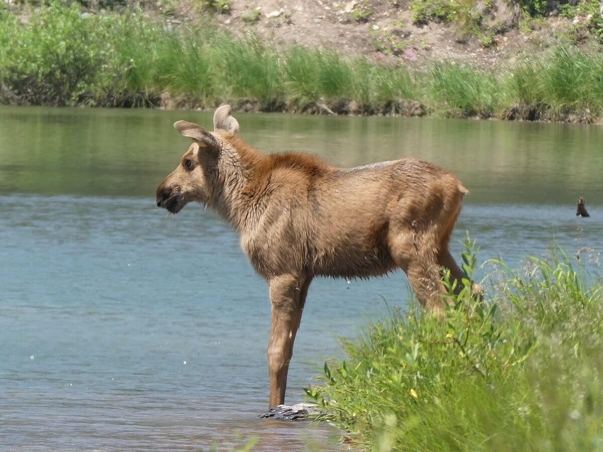
Fishercap Lake
Distance: 0.6 miles roundtrip
Elevation Gain: Minimal
Trailhead: Near the Swiftcurrent Motel
Trail type: Out and back
Level: Easy

A moose with her calf in Fishercap Lake!
The walk to Fishercap Lake is a super easy hike in Glacier National Park, but is highly recommended by us if you are in the area. Why? Well, because it’s an amazing place to spot moose! Often, moose are seen swimming and bathing in Fishercap Lake, and it’s such a short and easy walk, it’s kind of a no brainer if you’re already in the Many Glacier area!
There are a few different places you can start the Fishercap Lake walk. One way is right from the large parking lot for the Swiftcurrent Motel at the end of the Many Glacier road. Another way is from the parking lot for the Iceberg Lake trail. This is the way we started since we did this walk right after our Iceberg Lake hike. But either way you start, it will be about 0.3 miles to the lake.
If you start the Fishercap Lake hike at the Iceberg Lake trailhead, you’ll pass by this small but pretty waterfall
Once we got to Fishercap Lake, we were super excited to see two pairs of cows with their young swimming and feeding in the lake! We stayed there for quite some time just observing them from afar…it was amazing!
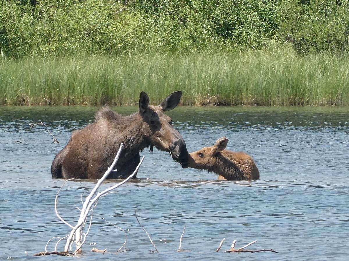
Just remember to keep your distance from any wildlife you do see on the Glacier trails. Don’t try to get close to the moose. Instead, bring some binoculars or a camera with a good zoom so that you can keep a good distance without disturbing them. If a moose starts to come out of the water towards where you’re standing, leave the area and give it space.
Other options for hiking in Many Glacier with more time
We loved all four of these Glacier National Park hikes so much, but there are plenty others to choose from in the Many Glacier area!
Grinnell Lake - 6.6 miles, 40 feet elevation gain
This is an easier walk to Lower Grinnell Lake, the beautiful lake seen in the valley below from the Grinnell Glacier hike.
Ptarmigan Tunnel - 10.6 miles, 2300 feet elevation gain
This Glacier hike takes you to a tunnel built into the cliffside of the Ptarmigan Wall, which is usually open mid-July to September. This hike can be combined with Iceberg Lake for a total of 14.8 miles.
Backpacking option: Swiftcurrent trail to the Granite Chalet - 7.6 miles, 2285 feet elevation gain to the pass.
This trail in Glacier goes up and over a beautiful pass and connects to the Highline Trail at the Granite Chalet.
Best Hikes in Glacier National Park: Two Medicine
The Going to the Sun Road and Many Glacier areas of the park are likely to have high crowding, and your chances of finding solitude on the trails in Glacier in these areas are slim.
Two Medicine is a great place to find some Glacier National Park hikes with solitude and low crowds. It was such a great break from the crowds we encountered in the Many Glacier and Logan Pass areas of the park! And we promise you, the scenery here is no less stunning.
Map of hikes in Glacier National Park in Two Medicine

Map of the Two Medicine area taken from the NPS. Our favorite hikes in Glacier National Park in Two Medicine are highlighted in blue.
Pitamakan Pass
Distance: 15.2 miles roundtrip (add an extra 1.2 miles roundtrip to go to Pitamakan Overlook)
Elevation Gain: 2400 feet
Trailhead: The North Shore Trailhead in the Two Medicine campground
Trail type: Out and back (but can be made into a loop, see below)
Level: Moderate (solely because of the distance – but the trail gains elevation slowly and has an easy-to-follow path)
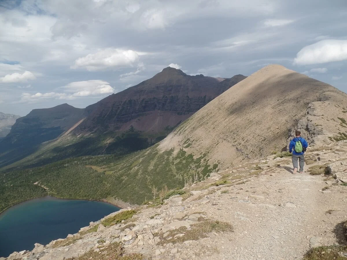
On top of Pitamakan Pass in Glacier
Pitamakan Pass is a highly underrated hike in Glacier National Park. I think its location in the remote Two Medicine area combined with its distance is what keeps people away from it, but if you’re willing to go a bit off the beaten path, you’ll be rewarded here with views that you’ll likely have all to yourself at the top! Just to give you an idea, we only saw two other pairs of people on the entire 15 miles of this Glacier National Park hike!
The Pitamakan Pass hike starts at the base of Two Medicine Lake and weaves its way through a forested valley with a very gradual elevation gain, ending with some exposed switchbacks that bring you up the final climb to the pass.

The final climb up to Pitamakan Pass on a steep set of switchbacks

Views from the top of Pitamakan Pass!
The Two Medicine area is notorious for high winds, and we definitely experienced this up on the pass! Make sure to bring layers and a good wind breaker for this Glacier National Park hike.
You’ll also be in bear territory on the hike out to the pass. Because there aren’t many hikers on this Glacier trail, it’s even more important to be extra vigilant, carry bear spray, and hike with others (see more about bear safety on the trails in our tips for hiking in Glacier below).
Overall, the Pitamakan Pass hike in Glacier National Park is long, but the views from the pass are stunning, and there is a good chance you can enjoy it peacefully all to yourself when you get to the top. But there is also a way you can combine the Pitamakan Pass hike with another trail in Glacier National Park to make it a loop hike that gives you sweeping views over the entire Two Medicine area…
Pitamakan Pass-Dawson Pass Loop
While the hike to Pitamakan Pass is quite long on its own, it’s actually often combined with another hike in the area, Dawson Pass, to make one large 17.5 mile loop. This epic Glacier hike combines two passes and circles behind two prominent peaks…Mt. Flinsch and Mt. Morgan. The trail that connects the passes behind the two peaks involves sections of narrow and sometimes exposed ledge walks, but it gives stunning views into the valley below.

Views from Pitamakan Overlook, just before the start of the Pitamakan-Dawson connector trail - an epic hike in Glacier National Park
Hiking the full Pitamakan-Dawson Loop was actually our original intent, but the high winds that day kept us from braving the narrow ledges and we turned around at Pitamakan Pass. But we’ll be back!
Other options for hiking in Two Medicine with more time
If you have more time (lucky you!) or want to look at other hikes in Glacier in the Two Medicine area, here are some noteworthy options:
Dawson Pass - 6.5 miles, 2450 feet elevation gain
This is the route that connects with Pitamakan Pass to make an awesome loop hike in Glacier, but it can also be certainly done on its own as an out and back hike.
Scenic Point - 7.8 miles, 2350 feet elevation gain
A steep out and back hike that leads to an overlook over the valley.
Upper Two Medicine Lake - 9.6 miles, 350 feet elevation gain
An easier walk around Two Medicine Lake to Upper Two Medicine Lake.
How Many Days Do You Need in Glacier National Park?

Now that you have an idea of the epic trails in Glacier, it’s time to make a game plan! With so many amazing hikes in Glacier National Park to choose from, you might be wondering how much time you should plan to visit so you can hit as many as can.
Well, to give you an idea, we have spent a total of 7 days in the park, but still feel like we have only scratched the surface at experiencing all of the epic Glacier National Park hikes. But the good news is, you can always go back…which we plan on doing soon!
For a first time visit where you’re looking to do a few of the best hikes in Glacier National Park, 4 days is a good amount of time. This allows you to spend two days driving the Going to the Sun Road and doing some hikes off this road, and then one day hiking in Many Glacier and one day hiking in Two Medicine.
Here, we’ll give you some Glacier National Park itineraries for one to four days on the Glacier trails to help you squeeze in as many of the best hikes in Glacier as you can!
One day Glacier National Park hiking itinerary
With one day, we would recommend driving the Going to the Sun Road and getting to Logan Pass early to hike the Highline Trail. This is the quintessential hike in Glacier National Park and will give you a chance to experience the famous Going to the Sun Road, too.
After you’re done hiking the Highline Trail, spend the rest of the afternoon driving the Going to the Sun Road, stopping at pull- offs to admire the views. If you have the time (and the energy after that long hike from the morning), you could do a shorter trail like the hike to St. Mary Falls, or even to the Hidden Lake Overlook, for sunset.
Alternatively for one day in Glacier, you could spend it in the Many Glacier area hiking the Grinnell Glacier trail in the morning, and then in the afternoon, drive the Going to the Sun Road from west to east, ending the day with a relaxing evening spent on Lake McDonald.
Two Days in Glacier National Park
With two days in Glacier, we would suggest devoting one day to the Highline Trail and the Going to the Sun Road as above, and the second day devoted to an awesome hike in the Many Glacier Area.
Three Days in Glacier National Park
Three days in Glacier gives you much more flexibility, especially when it comes to exploring the Going to the Sun Road!
Day 1: I would suggest spending the first day tackling the Highline Trail. After we hiked the Highline Trail, we spent the evening relaxing at Lake McDonald, which was an awesome way to end such an epic day on the trails.
Day 2: The second day will be used as a bit of a break from longer hiking, since tomorrow you will tackle another big one!
Spend this day exploring the Going to the Sun Road, stopping at all the pull- offs, with the option of doing one or two short hikes…Avalanche Lake, Hidden Lake, and St. Mary falls would be great for today.
Day 3: On Day 3, head to the Many Glacier area and hike to Grinnell Glacier (or any other hike in the area that intrigues you!).
Four days in Glacier National Park
Four days is a great amount of time to spend in the park. It gives you the chance to knock a few good hikes in Glacier National Park off your bucket list, explore the Going to the Sun Road, and visit three major areas of the park!
Spend the first three days in Glacier National Park as above, and on the fourth day, hike to Pitamakan Pass in Two Medicine, or if you’re up for it, compete the full Pitamakan Pass- Dawson Pass Loop. If you’re feeling a little low on energy from all the hikes on the previous days, I would still recommend checking this area out and doing a low-key easy hike around Two Medicine Lake just to experience this part of the park (or you could do a boat tour across Two Medicine lake as well!).
It will be a jam-packed four days of hiking in Glacier National Park, but so worth it!
Tips for Hiking in Glacier National Park
Before you strap on a pair of boots and tackle some of these amazing hikes in Glacier National Park, here are a few tips to keep in mind both before and during your visit to help you plan ahead!

Dealing with crowds in Glacier National Park
Glacier National Park is no secret. It’s one of the busiest National Parks in the country. And with a fairly narrow window throughout the year with the best combination of weather, accessibility, and open roads, you can bet on crowds in many of the popular areas and along some of the best hikes in Glacier National Park. The highest crowds are in July and August, and even on week days, the crowds aren’t that much lighter during this time.
Even with the new reservation system in place, the park service still says to expect congestion at the busiest places in the park, particularly at Logan Pass.
Here are some tips to help you plan ahead and try to avoid the crowds in Glacier National Park, as impossible as it may seem:
The most popular places, like Logan Pass and the Avalanche area near Lake McDonald, can fill up super early. Lately, the large lot at Logan Pass can be full by sunrise! Get there early for your best shot at getting a spot at trailheads for some of the best hikes in Glacier National Park.
Check out the NPS site to get real-time updates on parking status in popular areas. This is super useful and can save you driving time going to a destination where you won’t be able to get a spot.
Be flexible and have back up plans! That’s probably our best tip when it comes to planning a hike in Glacier National Park. Even if you have your sights set on one in particular, you can’t go wrong in this park, so a back up plan B or C won’t disappoint you. If a lot if full, it’s advised that you not linger and wait around so that you don’t add to the congestion. Instead, go somewhere else and try again later. Definitely don’t try to park where you’re not supposed to, like on vegetation.
Another reason for flexibility…some regions of the park may be closed off altogether at points throughout the day to mitigate the congestion or for constructions. The Many Glacier area, for example, was closed off 26 times one summer for this reason. In this case, a back- up plan is critical!
Try out some less popular Glacier National Park hikes! I know the popular ones are popular for a good reason, but getting off the beaten path can provide some solitude, reduce crowding, and still give you amazing views. It’s a win-win! The hikes in Two Medicine are particularly good for this.
Bears in Glacier National Park
When you’re hiking in Glacier National Park, you’re hiking in bear country. Both black bears and grizzly bears are common throughout the park. It’s definitely important to review information on how to hike safely in bear country before heading out on a Glacier National Park hike.
There were definitely times when we were on the trails in Glacier National Park where we felt a bit uncomfortable, especially on the less travelled trails. Sometimes we just had that eerie feeling like we were being watched in the silent forest, and we would occasionally see a giant scat pile sitting right in the middle of the trail. Not the most comforting feeling in the world, but being prepared helps, and thankfully, we had no encounters of our own.
Here are some important tips to know before heading out on a hike in Glacier National Park:
Check trail status before heading out on any Glacier National Park hike, or ask a ranger about recent bear activity on the trail you want to hike. When we were in the park, several trails were closed in the first few days we were there due to high bear activity, including the popular Highline Trail.
It’s always better to hike in a group than solo, and to constantly make (reasonable level) noise through talking or with a bear bell to make your presence known.
Stay vigilant and aware of your surroundings and keep your distance from any wildlife you do see.
Definitely carry bear spray (which you can rent for a day) on any hike in Glacier National Park and know how to use it as a last resort.
Don’t linger in areas of prime bear activity, particularly in huckleberry patches, which bears love to eat. While we were in the park, a person was approached by a bear because she was picking huckleberries!
While hiking or at camp, practice strict leave no trace principles. Never leave any food, scented items, or trash unattended and pack out everything you packed in.
Other tips for hiking in Glacier National Park
At the expense of sounding like a broken record, have back up plans when planning to hike in Glacier. Trails can be closed from crowding and bears as mentioned above, but also bad weather or construction delays can cause a hiccup in your original plans.
Before heading out to your Glacier hike, check road status and trail status updates and keep up to date with trail conditions and closures.
What to Pack for Hiking in Glacier National Park?
Here are some things we would specifically recommend you bring for a hike in Glacier National Park:
Layers/light rain coat or wind breaker for any changing weather.
A good pair of hiking boots for the frequent rocky sections and ledges found along many Glacier National Park trails.
Sunscreen/hat – many hikes in Glacier National Park have large sections of trail, if not the whole trail, that are exposed to the sun above tree line, so you’re gonna need these!
Water – and plenty of it! Pack at least three liters per person for long hikes.
Snacks – and a trash bad to carry out your waste.
Trekking poles – if you typically hike with these, bring them along for the descent along steeper trails.
Bear spray/bear bell – just in case!
Best time to hike in Glacier National Park
If you are looking to hike in Glacier National Park, the very best times to visit would be between the end of June and mid- September. During this time, the weather is favorable, the trails are generally clear of snow, and all visitor facilities are open.
And, importantly, the Going to the Sun Road, the main road through the park and on which some awesome trailheads are located, is typically open during this time.
Keep in mind that even in the summer, the weather can vary – the days might be hot but nights can still get chilly (think 40s to 50s). The park sits on the Continental Divide, so the east and west sides can be pretty different when it comes to weather. Generally, the east side is drier but windier (which we definitely experienced!). For this reason, when you’re hiking in Glacier National Park, always be prepared for rainy and/or windy conditions! Bring rain gear just in case, and dress in layers.
Also keep in mind that in these summer months, the crowd factor is high. Glacier National Park is an insanely popular park. Most days in the summer (even weekdays) are crowded, and parking lots and campgrounds fill early. So you’ll want to plan for early starts to your days.
Visiting Glacier National Park outside of the summer
If crowds aren’t your thing, the shoulder spring and fall seasons can be a good option, but might be a little tricky if you mainly want to hike in Glacier National Park.
Spring: The snow can linger on high elevation trails into early July depending on the previous season’s snowpack, so if you’re there in the spring, some trails may be off limits for you or you’ll need to come prepared for winter hiking. Be sure to check the trail status before heading out. Also, most of the Going to the Sun Road will be closed, so you’ll only have access to hikes in Glacier National Park in regions outside of this road. Other roads, such as the roads into Two Medicine and Many Glacier, usually open by the end of May, as do most visitor facilities and campgrounds.
Fall: In the fall, snow can start falling as early as September, and the Going to the Sun Road usually closes around Columbus Day weekend. Facilities like visitor centers start closing early to mid-October. Some campgrounds close altogether and some transition into primitive status only (meaning water and bathrooms may be closed for the season).
Winter: With winter comes lots of snow and closed roads, but if it’s your thing, you can do some great cross- country skiing in the park.
More Information for Your Glacier Hiking Trip
We hope you found this guide to the best hikes in Glacier National Park helpful in planning your Glacier itinerary!
For more information, check out our other Glacier National Park hiking guides:
THE HIGHLINE TRAIL: Check out The Ultimate Guide to Hiking the Highline Trail in Glacier National Park for everything you need to know to hike this famous trail!
GRINNELL GLACIER: Learn all about one of our favorite hikes in Glacier in our guide on Hiking to Grinnell Glacier in Glacier National Park
PITAMAKAN PASS: Read about the best hike in Glacier to avoid crowds in our guide to Hiking to Pitamakan Pass in Glacier National Park
ICEBERG LAKE: Find out what to expect on this popular trail in our complete guide to hiking to Iceberg Lake.
CRACKER LAKE: Want to hike to a stunningly blue glacier lake without the crowds? Check out our Cracker Lake hiking guide to learn how.
Which hikes in Glacier National Park are you looking forward to the most? Let us know below, and as always, feel free to ask us any questions about the trails in Glacier we mention here! We love to help.